Category:Aerial photographs of Allentown, Pennsylvania
Jump to navigation
Jump to search
Media in category "Aerial photographs of Allentown, Pennsylvania"
The following 91 files are in this category, out of 91 total.
-
 1900 - Eighth And Chew Looking North - Allentown PA.jpg 2,500 × 1,406; 697 KB
-
 1900 - View to Northwest From Hotel Allen - Seventh And Hamilton - Allentown PA.jpg 2,500 × 1,406; 550 KB
-
 1905 - Looking West over Allentown PA from Eighth and Turner Street.jpg 1,600 × 958; 295 KB
-
 1909 - Seventh and Linden - Looking Northwest - Postcard - Allentown PA.jpg 1,600 × 1,029; 508 KB
-
 1910 - Lehigh River Looking West Over First Ward - Allentown PA.jpg 2,600 × 1,462; 472 KB
-
 1910 - Looking Southwest from Eighth and Turner Streets Allentown PA.jpg 1,024 × 673; 160 KB
-
 1910 - Seventh Street looking north from Center Square Allentown PA.jpg 1,600 × 1,011; 505 KB
-
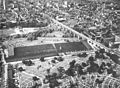
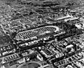
 1920 - Allentown Fairgrounds.jpg 1,593 × 1,181; 486 KB
-
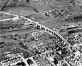
 1920 - Eighth Street Bridge - Looking South - Aerial - Allentown PA.jpg 4,096 × 2,731; 1.15 MB
-
 1920 - Eighth Street Bridge - Looking South - Aerial 2 - Allentown PA.jpg 4,096 × 2,731; 1.35 MB
-
 1922 - Southwest Allentown - Allentown PA.jpg 1,500 × 897; 235 KB
-
 1925 - Aerial Allentown 1st and 9th Wards.jpg 1,524 × 1,948; 495 KB
-
 1925 - Aerial Allentown CBD.jpg 1,541 × 1,890; 465 KB
-
 1925 - Looking East from 9th between Tilghman and Allen to Lehigh River.jpg 1,582 × 1,931; 617 KB
-
-
 1925 - South of Hamilton 2d and 3d Wards looking East.jpg 1,611 × 1,897; 649 KB
-
 1925 - Union Boulevard East of Lehigh River - Allentown PA.jpg 1,300 × 1,740; 343 KB
-
 1925 - West End 17th and 11th Wards.jpg 1,558 × 1,950; 599 KB
-
 1925 - West End looking west from Mack Trucks Plant 3A.jpg 1,551 × 1,897; 561 KB
-

-
 1928 - Northeast Allentown - 19 May MC - Allentown PA.jpg 3,872 × 4,824; 3.39 MB
-
 1929 - Union Boulevard Construction - Allentown PA.jpg 1,517 × 1,900; 361 KB
-
 1930 - Fairview Cemetary and 3d Ward looking North.jpg 1,511 × 1,106; 396 KB
-
 1930 - Second Ward Looking West - Allentown PA.jpg 2,400 × 1,350; 802 KB
-
 1930 - South First Ward Looking West From Lehigh River - Allentown PA.jpg 2,500 × 1,406; 777 KB
-
 1930 - Union Boulevard and Plymouth Street - 15th Ward - East Allentown PA.jpg 2,400 × 1,878; 838 KB
-
 1931 - Cedar Crest College - Looking West - Allentown PA.jpg 2,400 × 1,854; 647 KB
-
 1931 - Central Business District - Airphoto - Allentown PA.jpg 2,048 × 1,614; 795 KB
-
 1931 - Mountainville - 4th Street - Looking North - Allentown PA.jpg 2,400 × 1,926; 827 KB
-
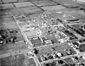
 1931 - Muhlenburg College - Campus Looking Northeast - Allentown PA.jpg 2,400 × 1,840; 860 KB
-
 1931 - Muhlenburg College - West Campus - Allentown PA.jpg 2,400 × 1,880; 866 KB
-
 1931 - Tilghman Street Viaduct - Looking East - Allentown PA.jpg 2,400 × 1,922; 1.04 MB
-
 1937 - Aerial view of Allentown Bethlehem Easton Airport - Northward - Allentown PA.jpg 2,400 × 1,859; 607 KB
-
 1938 - Central Business District - Looking East - Allentown PA.jpg 2,400 × 1,883; 745 KB
-
 1938 - Central Business District - Looking East 2 - Allentown PA.jpg 2,400 × 1,880; 810 KB
-
 1938 - Central Business District - Looking East 3 - Allentown PA.jpg 2,400 × 1,867; 935 KB
-
 1938 - Central Business District - Looking NorthEast - Allentown PA.jpg 2,400 × 1,942; 1,001 KB
-
 1938 - Eleventh Ward looking East - Allentown PA.jpg 2,400 × 1,880; 1.04 MB
-
 1938 - Fairgrounds looking East - Allentown PA.jpg 2,400 × 1,965; 1.13 MB
-
 1938 - Fairgrounds looking East 2 - Allentown PA.jpg 2,400 × 1,933; 1.05 MB
-
 1938 - Fairgrounds looking North West Allentown PA.jpg 2,400 × 1,931; 1.02 MB
-
 1938 - Fairgrounds looking Northeast - Allentown PA.jpg 2,400 × 1,933; 1.08 MB
-
 1938 - Fairgrounds looking Northeast 2 - Allentown PA.jpg 2,400 × 1,959; 1.19 MB
-
 1938 - Fairgrounds looking Northeast 3 - Allentown PA.jpg 2,400 × 1,930; 1.15 MB
-
 1938 - Mack Plant 3 and 3A - Allentown PA.jpg 2,400 × 1,895; 838 KB
-
 1938 - Mack Plant 4 - Allentown PA.jpg 2,400 × 1,949; 752 KB
-
 1939 - Air Photo - Allentown Fair - Allentown PA.jpg 2,048 × 1,675; 685 KB
-
 1939 - Air Photo 2 - Allentown Fair - Allentown PA.jpg 2,048 × 1,147; 542 KB
-
 1939 - Air Photo 3 - Allentown Fair - Allentown PA.jpg 3,045 × 1,376; 530 KB
-
 1939 - Air Photo 4 - Allentown Fair - Allentown PA.jpg 3,110 × 1,348; 736 KB
-
 1939 - Air Photo 5 - Allentown Fair - Allentown PA.jpg 2,048 × 1,684; 679 KB
-
 1940 - Central Business District Looking West - Allentown PA.jpg 1,200 × 675; 248 KB
-
 1940 - Fourth And Liberty Street Looking North - Allentown PA.jpg 2,500 × 1,406; 620 KB
-
 1940 - Industrial Area West of Lehigh River - Allentown PA.jpg 2,500 × 1,406; 573 KB
-
 1940 - View Looking East From Eighth Street Bridge - Allentown PA.jpg 2,500 × 1,406; 519 KB
-
 1941 - Aerial Photograph of West End - Allentown PA.jpg 2,000 × 1,331; 770 KB
-
 1945 - Mack Trucks - Monthly Magazine - Nov - Allentown PA.jpg 944 × 1,400; 456 KB
-
 1950 - Highland Park Apartments - Airphoto - Allentown PA.jpg 1,400 × 681; 348 KB
-
 1958 - Airport Drive-In Airphoto - Allentown PA.jpg 2,048 × 1,152; 286 KB
-
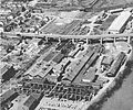 1959 - Lehigh Structural Steel Company Allentown PA.jpg 2,000 × 1,672; 1.06 MB
-
 1960 - Cedar Crest Boulevard and Hamilton Street - Dorneyville - Allentown PA.jpg 2,500 × 1,406; 540 KB
-
 1962 - View Of Central Buisness District Looking Northeast - Allentown PA.jpg 2,500 × 1,406; 699 KB
-
 1964 - Cedar Beach Pool - Allentown PA.jpg 1,500 × 960; 252 KB
-
 1965 - 4th and Linden Looking N - East Side - 1 Apr - Allentown PA.jpg 2,000 × 1,334; 657 KB
-
 1965 - 4th and Linden Looking N - West Side - 1 Apr - Allentown PA.jpg 2,000 × 1,333; 739 KB
-
 1965 - 5th and Hamilton Streets - 1 Apr - Allentown PA.jpg 2,000 × 1,334; 651 KB
-
 1965 - Allentown School District Offices - 1 Apr - Allentown PA.jpg 1,350 × 900; 285 KB
-
 1965 - Allentown Terminal RR Station - 1 Apr - Allentown PA.jpg 2,000 × 1,334; 774 KB
-
 1965 - Central Buisness District Looking NW - 1 Apr - Allentown PA.jpg 2,000 × 2,000; 1.38 MB
-
 1965 - Fourth Street Redevelopment Area - Looking E - 1 Apr - Allentown PA.jpg 2,000 × 1,333; 503 KB
-
 1965 - Fourth Street Redevelopment Area - Looking N - 1 Apr - Allentown PA.jpg 2,000 × 1,337; 982 KB
-
 1965 - Fourth Street Redevelopment Area - Looking SE - 1 Apr - Allentown PA.jpg 2,000 × 1,348; 826 KB
-
 1965 - Fourth Street Redevelopment Area - LVRR Freight Yard - 1 Apr - Allentown PA.jpg 2,000 × 1,332; 635 KB
-
 1965 - Fourth Street Redevelopment Area - Phoenix Silk Mill - 1 Apr - Allentown PA.jpg 2,000 × 1,336; 801 KB
-
 1965 - Fourth Street Redevelopment Area -1st Ward South End - 1 Apr - Allentown PA.jpg 2,000 × 1,334; 674 KB
-
 1965 - Lehigh County Court Houses - Looking N - 1 Apr - Allentown PA.jpg 2,000 × 1,334; 719 KB
-
 1965 - Lehigh Valley Railroad Freight Yard - 1 Apr - Allentown PA.jpg 2,000 × 1,333; 592 KB
-
 1965 - Old Lehigh County Prison - 1 Apr - Allentown PA.jpg 2,000 × 1,332; 600 KB
-
 1965 - Phoenix Mills - 1 Apr - Allentown PA.jpg 2,000 × 1,333; 891 KB
-
 1965 - UGI Gas Tower - 1 Apr - Allentown PA.jpg 2,000 × 1,333; 702 KB
-
 1965 - Union Street and Little Lehigh - 1 Apr - Allentown PA.jpg 2,000 × 1,333; 962 KB
-
 1967 - 7th Street Pike - Airphoto - Allentown PA.jpg 2,048 × 1,575; 988 KB
-
 1968 - Aerial Photograph Central Business District- Allentown PA.jpg 1,551 × 1,053; 656 KB
-
 1968 - Allentown PA Aireal Photograph.jpg 1,552 × 1,072; 445 KB
-
 1969 - Airphoto - Dorney Park - Allentown PA.jpg 1,024 × 695; 272 KB
-
 1976 - Shankweiler Drive-in Airphoto - 15 Apr MC - Allentown PA.jpg 1,453 × 915; 401 KB
-
 2021 - 1100 Block Hamilton Street - NW - Drone - Allentown PA.jpg 4,096 × 2,721; 1.42 MB
-
 2021 - 500 Block Hamilton Street - North Side - Drone - Allentown PA.jpg 4,096 × 2,720; 1.68 MB
-
 2021 - 600 Block Hamilton Street - NE View - Drone - Allentown PA.jpg 4,096 × 2,720; 1.39 MB
-
 Allentown, Pennsylvania (1) (2895771731).jpg 1,280 × 960; 69 KB
-
 Allentown, Pennsylvania (2896613266).jpg 1,280 × 960; 80 KB


_(2895771731).jpg)
.jpg)