Category:Administration Building, Battlefields Park
Jump to navigation
Jump to search
| Object location | | View all coordinates using: OpenStreetMap |
|---|
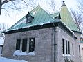
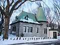
English: The Administration Building, 390, rue de Bernières, Québec, Québec, Canada, is located on modestly landscaped grounds at the National Battlefields Park, which comprises 250 acres of land, largely known as the Plains of Abraham in Québec. The single-storey stone structure has a steep bell-cast copper roof, decorative dormers and a distinct round corner tower with a conical roof. The designation is confined to the footprint of the building.
Français : Le bureau de l’administration, 390, rue de Bernières, Québec, Québec, Canada, se dresse sur un terrain aménagé de façon modeste dans le parc des Champs-de-Bataille-Nationaux, qui couvre 250 acres de terrain et est plus souvent appelé les Plaines d’Abraham à Québec. Cet édifice de pierre d’un étage possède un toit en cuivre très pentu et évasé, des lucarnes décoratives et une tour d’angle circulaire à toit conique particulière. La désignation se limite au tracé au sol du bâtiment.
This category is for a cultural heritage site in Canada, number 10229
|
administrative building in Quebec City  | |||||
| Upload media | |||||
| Instance of | |||||
|---|---|---|---|---|---|
| Location | The Battlefields Park, La Cité-Limoilou, Quebec City, Quebec, Capitale-Nationale, Quebec, Canada | ||||
| Street address |
| ||||
| Heritage designation | |||||
 | |||||
Subcategories
This category has only the following subcategory.
B
Media in category "Administration Building, Battlefields Park"
The following 22 files are in this category, out of 22 total.
-
 390 rue De Bernieres - 01.jpg 3,264 × 2,448; 3.15 MB
-
 390 rue De Bernieres - 02.jpg 3,264 × 2,448; 2.66 MB
-
 390 rue De Bernieres - 03.jpg 3,264 × 2,448; 2.52 MB
-
 390 rue De Bernieres - 04.jpg 4,608 × 3,456; 3.58 MB
-
 390 rue De Bernieres.jpg 4,608 × 3,456; 3.55 MB
-
 390, De Bernières Avenue, Quebec City.jpg 5,184 × 3,456; 7 MB
-
 Administration Battlefields Park 01.JPG 4,000 × 3,000; 1.26 MB
-
 Administration Battlefields Park 02.JPG 4,000 × 3,000; 1.8 MB
-
 Administration Battlefields Park 03.JPG 4,000 × 3,000; 2.19 MB
-
 Administration Battlefields Park 04.JPG 4,000 × 3,000; 1.88 MB
-
 Administration Battlefields Park 05.JPG 4,000 × 3,000; 1.82 MB
-
 Administration Battlefields Park 06.JPG 4,000 × 3,000; 1.27 MB
-
 Administration Battlefields Park 07.JPG 5,152 × 3,864; 2.16 MB
-
 Administration Battlefields Park 08.JPG 5,152 × 3,864; 2.19 MB
-
 Administration Battlefields Park 09.JPG 5,152 × 3,864; 4.09 MB
-
 Parc des Champs-de-Bataille 35.jpg 4,608 × 3,456; 3.38 MB
-
 Parc des Champs-de-Bataille 36.jpg 4,608 × 3,456; 3.35 MB
-
 Parc des Champs-de-Bataille 37.jpg 4,608 × 3,456; 3.12 MB
-
 Parc des Champs-de-Bataille 38.jpg 4,608 × 3,456; 3.4 MB
-
 Parc des Champs-de-Bataille 39.jpg 4,608 × 3,456; 3.39 MB
-
 Parc des Champs-de-Bataille 40.jpg 4,608 × 3,456; 3.63 MB
-
 Parc des Champs-de-Bataille 41.jpg 4,608 × 3,456; 3.41 MB


