Category:Abercregan
Jump to navigation
Jump to search
human settlement in United Kingdom | |||||
| Upload media | |||||
| Instance of | |||||
|---|---|---|---|---|---|
| Location | Neath Port Talbot, Wales | ||||
 | |||||
English: Abercregan is a village in the Welsh county borough of Neath Port Talbot, Glamorgan. It is situated around 12 km north-east of Port Talbot and just west of Cymmer, and is also close to the River Afan. Abercregan was once a thriving mining community but since the decline of the British coal industry, much of the housing has been demolished and most of its inhabitants moved to neighbouring villages. Now a small village of around 30 houses, Abercregan is in surroundings which have returned to their former pre-industrial rural condition. Abercregan is within the boundaries of the Afan Forest Park which is a joint venture between Forest Enterprise, the Local Authority and local businesses which promote and provide provisions for green tourism in the area. The local authority decided to move the Field Study Centre in Abercregan to Margam Park and demolish the building which once housed the village school.
Media in category "Abercregan"
The following 10 files are in this category, out of 10 total.
-
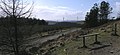
 A view across the Afan Valley at Abercregan (geograph 2758077).jpg 640 × 428; 145 KB
-
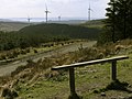 Bench overlooking a wind farm - geograph.org.uk - 738280.jpg 640 × 480; 79 KB
-
 Bench with a windy view - geograph.org.uk - 738319.jpg 640 × 296; 47 KB
-

-
 Ffynnon Oer wind farm - geograph.org.uk - 739361.jpg 640 × 480; 95 KB
-
-
 Westward view along the Afan Valley (geograph 2191172).jpg 640 × 431; 96 KB
-
 Abandoned on the moor - geograph.org.uk - 1020284.jpg 640 × 427; 188 KB
-
 Forestry footpath - geograph.org.uk - 352293.jpg 480 × 640; 107 KB
-
 Forestry footpath along Cwm Afan - geograph.org.uk - 352311.jpg 640 × 480; 74 KB
.jpg)


.jpg)


