Category:Abbotsham
Jump to navigation
Jump to search
village in United Kingdom  | |||||
| Upload media | |||||
| Instance of | |||||
|---|---|---|---|---|---|
| Location | Torridge, Devon, South West England, England | ||||
| Population |
| ||||
 | |||||
Subcategories
This category has the following 3 subcategories, out of 3 total.
A
H
T
Media in category "Abbotsham"
The following 200 files are in this category, out of 244 total.
(previous page) (next page)-
 "The Thatched Inn" pub, Abbotsham, Devon - geograph.org.uk - 7131256.jpg 4,000 × 3,000; 5.49 MB
-
 'The Pig on the Hill' - geograph.org.uk - 6544955.jpg 1,024 × 792; 159 KB
-

-
 A39 bridge over Abbotsham-Bideford road - geograph.org.uk - 3641695.jpg 1,024 × 768; 93 KB
-
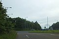
 A39 junction for Abbotsham - geograph.org.uk - 3641681.jpg 1,024 × 768; 113 KB
-
 A39 near Abbotsham - geograph.org.uk - 5473590.jpg 2,008 × 1,288; 1.49 MB
-
 A39 towards Abbotsham Cross roundabout - geograph.org.uk - 5474318.jpg 2,060 × 1,320; 1.34 MB
-
 Abbotsham , Country Road - geograph.org.uk - 4249626.jpg 4,288 × 2,848; 6.4 MB
-
 Abbotsham , Pump Lane - geograph.org.uk - 4249390.jpg 4,288 × 2,848; 5.72 MB
-
 Abbotsham , Pump Lane - geograph.org.uk - 4249391.jpg 4,288 × 2,848; 6.08 MB
-
 Abbotsham , Pump Lane - geograph.org.uk - 4249392.jpg 4,288 × 2,848; 6.63 MB
-
 Abbotsham , Small Lane - geograph.org.uk - 4249393.jpg 4,288 × 2,848; 5.37 MB
-
 Abbotsham , Village Lane - geograph.org.uk - 4249617.jpg 4,288 × 2,848; 5.96 MB
-
 Abbotsham , Water Pump - geograph.org.uk - 4249396.jpg 2,848 × 4,288; 6.32 MB
-
 Abbotsham Baptist Chapel - geograph.org.uk - 6545930.jpg 1,024 × 768; 216 KB
-
 Abbotsham Cliff - geograph.org.uk - 1302782.jpg 640 × 480; 66 KB
-
 Abbotsham Cliff - geograph.org.uk - 1302790.jpg 640 × 480; 234 KB
-
 Abbotsham Cliff - geograph.org.uk - 1302796.jpg 640 × 480; 123 KB
-
 Abbotsham Cliff Footbridge - geograph.org.uk - 6846707.jpg 1,600 × 1,067; 603 KB
-
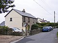
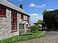
 Abbotsham Cottages - geograph.org.uk - 6846899.jpg 1,600 × 1,200; 559 KB
-
 Abbotsham Cross, A39 - geograph.org.uk - 3289230.jpg 640 × 480; 49 KB
-
 Abbotsham Cross, A39 - geograph.org.uk - 3289251.jpg 640 × 480; 52 KB
-
 Abbotsham from the west - geograph.org.uk - 742896.jpg 640 × 317; 48 KB
-
 Abbotsham Post Office - geograph.org.uk - 2023712.jpg 680 × 1,024; 211 KB
-
 Abbotsham Road, entering Abbotsham - geograph.org.uk - 5911722.jpg 1,024 × 683; 251 KB
-
 Abbotsham Village Hall - geograph.org.uk - 2023716.jpg 1,024 × 680; 179 KB
-
 Abbotsham Village Hall - geograph.org.uk - 2023722.jpg 1,024 × 680; 180 KB
-

-
 Arable field near Abbotsham - geograph.org.uk - 4454903.jpg 800 × 531; 90 KB
-
 Back road to Bideford - geograph.org.uk - 6545048.jpg 1,024 × 795; 251 KB
-
 Base of Abbotsham Cliff - geograph.org.uk - 1302743.jpg 640 × 480; 102 KB
-
 Beef cattle near Abbotsham Court - geograph.org.uk - 1303770.jpg 640 × 481; 82 KB
-
 Bus stop opposite the parish church - geograph.org.uk - 4547754.jpg 640 × 480; 93 KB
-
 BWH&AR Cornborough cliffs bridge 1969-70.jpg 1,744 × 1,168; 176 KB
-
 BWH&AR Cornborough Cliffs cutting in 1969-70.jpg 1,792 × 1,664; 295 KB
-
 Caravan-campsite near Abbotsham - geograph.org.uk - 5034410.jpg 800 × 531; 143 KB
-
 Clovelly Road - geograph.org.uk - 6546962.jpg 1,024 × 807; 187 KB
-
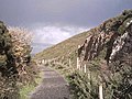
 Coast path in former railway cutting - geograph.org.uk - 5912222.jpg 1,024 × 683; 254 KB
-
 Coastal Beach View - geograph.org.uk - 4483913.jpg 800 × 600; 135 KB
-
 Coastal path - geograph.org.uk - 4483877.jpg 800 × 600; 90 KB
-
 Coastal Path Scene - geograph.org.uk - 4483894.jpg 800 × 600; 96 KB
-
 Coastal Path Sign - geograph.org.uk - 4483906.jpg 800 × 600; 115 KB
-
 Coastal Path View - geograph.org.uk - 4483872.jpg 800 × 600; 104 KB
-
 Coastal Scene - geograph.org.uk - 4483888.jpg 800 × 600; 99 KB
-
 Coastal view with a glimpse of Lundy - geograph.org.uk - 6545957.jpg 1,024 × 768; 156 KB
-
 Coastline and parasol mushrooms - geograph.org.uk - 6604463.jpg 4,032 × 3,024; 3.42 MB
-
 Cornborough Cliff - geograph.org.uk - 1302807.jpg 640 × 480; 94 KB
-
 Cornborough Cliff - geograph.org.uk - 6846713.jpg 1,600 × 1,200; 887 KB
-
 Cornborough cliff on a summer's day - geograph.org.uk - 130799.jpg 640 × 480; 83 KB
-
 Cottage extension in progress - geograph.org.uk - 6545054.jpg 1,024 × 768; 185 KB
-
 Country road near Abbotsham - geograph.org.uk - 4454897.jpg 1,024 × 680; 284 KB
-
 Country Scene - geograph.org.uk - 4197511.jpg 800 × 600; 102 KB
-
 Disused railway near Westward Ho^ - geograph.org.uk - 1401069.jpg 640 × 480; 90 KB
-

-
 East Pusehill - geograph.org.uk - 6544952.jpg 1,024 × 786; 206 KB
-
 Entrance, Westacott Farm - geograph.org.uk - 6545962.jpg 1,024 × 768; 269 KB
-
 Farm Path View - geograph.org.uk - 4483942.jpg 640 × 480; 92 KB
-
 Farmland at Abbotsham Cross - geograph.org.uk - 4454909.jpg 1,024 × 680; 277 KB
-
 Farmland near Whitehouse Cross - geograph.org.uk - 6603699.jpg 1,024 × 762; 194 KB
-
 Farmyard, West Devon - geograph.org.uk - 1302705.jpg 640 × 480; 81 KB
-

-
 Footbridge at Green Cliff - geograph.org.uk - 74272.jpg 640 × 480; 57 KB
-
 Footbridge near Abbotsham Court - geograph.org.uk - 74277.jpg 640 × 480; 34 KB
-
 Footpath Sign at Green Cliff - geograph.org.uk - 2033354.jpg 1,024 × 682; 293 KB
-

-
 Footpath to Abbotsham Cliff - geograph.org.uk - 6545294.jpg 1,024 × 768; 325 KB
-
 Footpath to the coast - geograph.org.uk - 1302715.jpg 640 × 480; 125 KB
-
 Footpath towards Greencliff - geograph.org.uk - 6604532.jpg 4,032 × 3,024; 3.89 MB
-
 Former Schoolroom, Abbotsham - geograph.org.uk - 6545262.jpg 1,024 × 768; 227 KB
-
 Gate on the South West Coast Path - geograph.org.uk - 1303805.jpg 640 × 480; 135 KB
-
 Greencliff Farm - geograph.org.uk - 1303841.jpg 640 × 480; 109 KB
-
 Greencliff Farm - geograph.org.uk - 4483939.jpg 800 × 600; 99 KB
-
 Heather View - geograph.org.uk - 4483920.jpg 800 × 600; 92 KB
-
 Heliport at Lake - geograph.org.uk - 6604559.jpg 4,032 × 3,024; 1.96 MB
-
 Hidden pathway - geograph.org.uk - 6604543.jpg 4,032 × 3,024; 3.5 MB
-
 Kenwith Barton , Dwellings - geograph.org.uk - 4250718.jpg 4,288 × 2,848; 5.81 MB
-
 Kenwith Castle - 1988 - geograph.org.uk - 3287219.jpg 2,271 × 1,515; 524 KB
-
 Lane to Greencliff - geograph.org.uk - 6545941.jpg 1,024 × 801; 248 KB
-
 Lodge at Abbotsham Court - geograph.org.uk - 6545289.jpg 1,024 × 793; 206 KB
-
 Lodge at Abbotsham Court - geograph.org.uk - 742907.jpg 640 × 480; 94 KB
-
 Looking up Pusehill Road. - geograph.org.uk - 814408.jpg 640 × 480; 88 KB
-
 Lookout post on Kipling Tors - geograph.org.uk - 1302669.jpg 640 × 480; 101 KB
-
 Lookout post, Westward Ho1 - geograph.org.uk - 1820994.jpg 2,000 × 1,500; 836 KB
-
 Mermaid's Pool and Rock Nose - geograph.org.uk - 74280.jpg 480 × 640; 36 KB
-
 Mermaid's Pool Westward Ho^ - geograph.org.uk - 130804.jpg 640 × 480; 130 KB
-
 Mermaid's Pool, Westward Ho^ - geograph.org.uk - 3060849.jpg 1,024 × 768; 234 KB
-
 North side of Rickard's Down - geograph.org.uk - 742915.jpg 640 × 359; 77 KB
-

-
 Old railway line used for the South West Coast Path - geograph.org.uk - 6603248.jpg 4,032 × 3,024; 2.7 MB
-

-
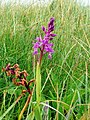 Orchis mascula, Early Purple Orchid - geograph.org.uk - 1303777.jpg 480 × 640; 154 KB
-
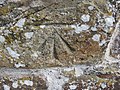 Ordnance Survey Cut Mark - geograph.org.uk - 3719952.jpg 4,000 × 3,000; 4.74 MB
-
 Path at Green Cliff - geograph.org.uk - 1302766.jpg 640 × 480; 101 KB
-
 Path Junction - geograph.org.uk - 4483925.jpg 800 × 600; 186 KB
-
 Path to Green Cliff - geograph.org.uk - 1302753.jpg 640 × 480; 130 KB
-
 Path to Green Cliff - geograph.org.uk - 6545950.jpg 1,024 × 768; 252 KB
-
 Path to Green Cliff - geograph.org.uk - 6545954.jpg 1,024 × 768; 309 KB
-
 Path to the Sea - geograph.org.uk - 4197501.jpg 800 × 600; 97 KB
-
 Pebbly Beach - geograph.org.uk - 4483882.jpg 800 × 600; 117 KB
-
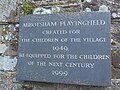 Plaque on the churchyard wall - geograph.org.uk - 4497858.jpg 640 × 480; 109 KB
-

-
 Pump Lane Cottages - geograph.org.uk - 4197474.jpg 800 × 585; 108 KB
-

-
 Road junction and some houses, Abbotsham, Devon - geograph.org.uk - 7131267.jpg 4,000 × 3,000; 5.39 MB
-
 Road passing the parish church - geograph.org.uk - 4547761.jpg 640 × 480; 89 KB
-
 Road past the post office, Abbotsham - geograph.org.uk - 1820537.jpg 2,000 × 1,338; 519 KB
-
 Rock Nose - geograph.org.uk - 1302680.jpg 640 × 480; 87 KB
-
 Rock Nose and Mermaid's Pool - geograph.org.uk - 1302677.jpg 640 × 480; 83 KB
-
 Rock shelf at low tide - geograph.org.uk - 1301619.jpg 640 × 480; 83 KB
-
 Rocky Lane - geograph.org.uk - 6604554.jpg 3,024 × 4,032; 5.26 MB
-
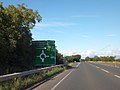
 Roundabout on A39 at Abbotsham Cross - geograph.org.uk - 4045471.jpg 1,024 × 683; 79 KB
-

-
 Sea Path View - geograph.org.uk - 4483931.jpg 800 × 600; 100 KB
-
 Seat outside the nursery school - geograph.org.uk - 4547786.jpg 640 × 480; 104 KB
-
 Sign for Abbotsham Cross and lay-by on A39 - geograph.org.uk - 3641652.jpg 1,024 × 768; 122 KB
-
 Signpost in Abbotsham - geograph.org.uk - 4454904.jpg 800 × 531; 173 KB
-
 Signs and path junction - geograph.org.uk - 6604454.jpg 4,032 × 3,024; 2.32 MB
-
 South West Coast Path - geograph.org.uk - 3061145.jpg 1,024 × 768; 270 KB
-
 South West Coast Path 1 - geograph.org.uk - 1303751.jpg 640 × 480; 84 KB
-
 South West Coast Path 2 - geograph.org.uk - 1303765.jpg 640 × 480; 104 KB
-
 South West Coast Path 3 - geograph.org.uk - 1303788.jpg 640 × 480; 82 KB
-
 South West Coast Path 4 - geograph.org.uk - 1303796.jpg 640 × 480; 112 KB
-

-

-

-

-
 South West Coast Path, Green Cliff - geograph.org.uk - 74275.jpg 640 × 480; 28 KB
-
 South West Mountain board centre - geograph.org.uk - 82815.jpg 427 × 640; 51 KB
-
 St Helen's Church of England Primary School - geograph.org.uk - 2023735.jpg 1,024 × 683; 193 KB
-
 St Helen's church, Abbotsham - interior looking east - geograph.org.uk - 7131240.jpg 4,000 × 3,000; 5.92 MB
-

-
 St Helen's church, Abbotsham, Devon - geograph.org.uk - 7131225.jpg 4,000 × 3,000; 6.83 MB
-
 St Helen, Abbotsham, gate - geograph.org.uk - 4547776.jpg 640 × 480; 129 KB
-
 St Helen, Abbotsham, war memorial - geograph.org.uk - 4547836.jpg 476 × 640; 95 KB
-
 Start of Path - geograph.org.uk - 4197488.jpg 800 × 600; 219 KB
-
 Terraced cottages, Abbotsham - geograph.org.uk - 6545304.jpg 1,024 × 768; 152 KB
-
 The coast, near Cornborough - geograph.org.uk - 3061204.jpg 1,024 × 768; 268 KB
-
 The Coastline Southwest of Westward Ho^ - geograph.org.uk - 2033368.jpg 1,024 × 682; 175 KB
-

-

-
 The Heliport at Lake. - geograph.org.uk - 814340.jpg 640 × 480; 88 KB
-
-
 The view east from Abbotsham Cross - geograph.org.uk - 3641673.jpg 1,024 × 768; 133 KB
-
 The western end of the coastal strip, Westward Ho^ - geograph.org.uk - 1821051.jpg 2,000 × 1,500; 1,008 KB
-
 Torridge , Buckleigh Road B3236 - geograph.org.uk - 4250725.jpg 4,288 × 2,848; 5.61 MB
-
 Torridge , Chaltaborough - geograph.org.uk - 4248148.jpg 4,288 × 2,848; 6.22 MB
-
 Torridge , Coastal Path - geograph.org.uk - 4247310.jpg 4,033 × 2,679; 7.9 MB
-
 Torridge , Coastal Path - geograph.org.uk - 4247596.jpg 4,288 × 2,848; 5.22 MB
-
 Torridge , Coastal Rocks - geograph.org.uk - 4247588.jpg 4,288 × 2,848; 6.62 MB
-
 Torridge , Coastal Rocks - geograph.org.uk - 4247593.jpg 4,288 × 2,848; 7.58 MB
-
 Torridge , Coastal Rocks - geograph.org.uk - 4247599.jpg 4,288 × 2,848; 5.44 MB
-
 Torridge , Coastal Scenery - geograph.org.uk - 4247449.jpg 4,288 × 2,848; 6.96 MB
-
 Torridge , Coastal Scenery - geograph.org.uk - 4247473.jpg 4,288 × 2,848; 6.7 MB
-
 Torridge , Coastal Scenery - geograph.org.uk - 4247590.jpg 4,288 × 2,848; 6.32 MB
-
 Torridge , Coastal Scenery - geograph.org.uk - 4247612.jpg 4,220 × 2,802; 5.58 MB
-
 Torridge , Coastal Scenery - geograph.org.uk - 4247625.jpg 4,288 × 2,848; 5.17 MB
-
 Torridge , Coastal Scenery - geograph.org.uk - 4247627.jpg 4,288 × 2,848; 6.01 MB
-
 Torridge , Coastal Scenery - geograph.org.uk - 4247637.jpg 4,288 × 2,848; 6.16 MB
-
 Torridge , Coastal Scenery - geograph.org.uk - 4247651.jpg 2,848 × 4,288; 6.32 MB
-
 Torridge , Coastal Scenery - geograph.org.uk - 4247671.jpg 3,999 × 2,656; 4.96 MB
-
 Torridge , Coastal Scenery - geograph.org.uk - 4247684.jpg 4,135 × 2,746; 7.88 MB
-
 Torridge , Coastal Scenery - geograph.org.uk - 4247685.jpg 4,288 × 2,848; 4.9 MB
-
 Torridge , Coastal Scenery - geograph.org.uk - 4247737.jpg 4,288 × 2,848; 6.77 MB
-
 Torridge , Coastal Scenery ^ Path - geograph.org.uk - 4247760.jpg 4,288 × 2,848; 6.48 MB
-
 Torridge , Coombe Cottage - geograph.org.uk - 4249646.jpg 4,288 × 2,848; 6.26 MB
-
 Torridge , Country Lane - geograph.org.uk - 4248088.jpg 4,288 × 2,848; 6.2 MB
-
 Torridge , Country Lane - geograph.org.uk - 4248091.jpg 4,288 × 2,848; 6.41 MB
-
 Torridge , Country Lane - geograph.org.uk - 4248096.jpg 4,288 × 2,848; 6.62 MB
-
 Torridge , Country Lane - geograph.org.uk - 4248107.jpg 2,848 × 4,288; 6.31 MB
-
 Torridge , Country Lane - geograph.org.uk - 4248110.jpg 4,288 × 2,848; 6.39 MB
-
 Torridge , Country Lane - geograph.org.uk - 4248124.jpg 4,288 × 2,848; 6.32 MB
-
 Torridge , Country Lane - geograph.org.uk - 4249650.jpg 4,288 × 2,848; 6.37 MB
-
 Torridge , Country Lane - geograph.org.uk - 4249652.jpg 4,288 × 2,848; 6.28 MB
-
 Torridge , Country Road - geograph.org.uk - 4249628.jpg 4,288 × 2,848; 6.58 MB
-
 Torridge , Country Road - geograph.org.uk - 4249630.jpg 4,288 × 2,848; 6.4 MB
-
 Torridge , Country Road - geograph.org.uk - 4249641.jpg 4,288 × 2,848; 6.68 MB
-
 Torridge , Country Road - geograph.org.uk - 4250719.jpg 4,288 × 2,848; 6.26 MB
-
 Torridge , Countryside Scenery - geograph.org.uk - 4247763.jpg 4,288 × 2,848; 6.46 MB
-
 Torridge , Countryside Scenery - geograph.org.uk - 4248158.jpg 4,288 × 2,848; 5.78 MB
-
 Torridge , Countryside Scenery - geograph.org.uk - 4250727.jpg 4,288 × 2,848; 5.06 MB
-
 Torridge , Countryside Scenery - geograph.org.uk - 4250737.jpg 4,288 × 2,848; 5.88 MB
-
 Torridge , Countryside Scenery - geograph.org.uk - 4250740.jpg 4,288 × 2,848; 6.13 MB
-
 Torridge , Footpath Stile - geograph.org.uk - 4250734.jpg 4,288 × 2,848; 6.53 MB
-
 Torridge , Garden Path - geograph.org.uk - 4249647.jpg 4,288 × 2,848; 6.25 MB
-
 Torridge , Grassy Field - geograph.org.uk - 4247739.jpg 4,288 × 2,848; 5.66 MB
-
 Torridge , Grassy Field - geograph.org.uk - 4247766.jpg 4,288 × 2,848; 5.31 MB
-
 Torridge , Grassy Field - geograph.org.uk - 4248099.jpg 4,288 × 2,848; 6.49 MB
-
 Torridge , Grassy Field - geograph.org.uk - 4249639.jpg 4,288 × 2,848; 4.46 MB
-
 Torridge , Grassy Field - geograph.org.uk - 4249642.jpg 4,288 × 2,848; 4.4 MB
-
 Torridge , Grassy Field - geograph.org.uk - 4249644.jpg 4,288 × 2,848; 5.49 MB
-
 Torridge , Grassy Field ^ Coastline - geograph.org.uk - 4247750.jpg 4,288 × 2,848; 6.18 MB
-
 Torridge , Grassy Field ^ Sheep - geograph.org.uk - 4247748.jpg 4,288 × 2,848; 4.03 MB
-
 Torridge , Grassy Field ^ Sheep - geograph.org.uk - 4247771.jpg 4,288 × 2,848; 5.52 MB
-
 Torridge , Grassy Field ^ Sheep - geograph.org.uk - 4247779.jpg 4,288 × 2,848; 6.3 MB
-
 Torridge , Grassy Field ^ Sheep - geograph.org.uk - 4247780.jpg 4,288 × 2,848; 6.63 MB
-
 Torridge , Grassy Field ^ Sheep - geograph.org.uk - 4248101.jpg 4,288 × 2,848; 6.16 MB
-
 Torridge , Grassy Garden - geograph.org.uk - 4249648.jpg 4,288 × 2,848; 6.46 MB
-
 Torridge , Heron's Lea Drive - geograph.org.uk - 4250726.jpg 4,288 × 2,848; 6.23 MB
-
 Torridge , Path - geograph.org.uk - 4247790.jpg 4,288 × 2,848; 6.21 MB
-
 Torridge , Path - geograph.org.uk - 4247791.jpg 4,288 × 2,848; 6.17 MB


