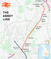
Category:Abbey Line
Jump to navigation
Jump to search
The Abbey Line is a railway line from Watford Junction to St Albans Abbey railway station. The 6.5-mile (10.5 km) route passes through town and countryside.
Railway line from Watford Junction to St Albans Abbey in England | |||||
| Upload media | |||||
| Instance of |
| ||||
|---|---|---|---|---|---|
| Part of |
| ||||
| Location | Hertfordshire, East of England, England | ||||
| Commissioned by | |||||
| Owned by | |||||
| Operator | |||||
| Date of official opening |
| ||||
| Length |
| ||||
| Terminus |
| ||||
 | |||||
Subcategories
This category has the following 8 subcategories, out of 8 total.
Media in category "Abbey Line"
The following 16 files are in this category, out of 16 total.
-
Abbey Line looking north from Watford North.jpg 2,592 × 1,936; 2.89 MB
-
Abbey Line.png 1,767 × 2,057; 2.21 MB
-
Buckinghamshire railways, 1880.png 1,053 × 745; 171 KB
-
How Wood, Park Street Lane railway bridge - geograph.org.uk - 595685.jpg 640 × 480; 106 KB
-
How Wood, Railway line to St Albans Abbey - geograph.org.uk - 594771.jpg 640 × 480; 116 KB
-
Pleasant Lane, Bricket Wood - geograph.org.uk - 1550292.jpg 640 × 428; 95 KB
-
Railway through Bricket Wood Common - geograph.org.uk - 71825.jpg 640 × 425; 129 KB
-
St Albans Abbey branch, Bricket Wood - geograph.org.uk - 1552204.jpg 640 × 428; 104 KB
-
St Albans, The Abbey Flyer line - geograph.org.uk - 1301625.jpg 640 × 480; 127 KB
-
St Albans, The Abbey Flyer line - geograph.org.uk - 1328532.jpg 640 × 480; 120 KB
-
St Albans, The Abbey Flyer line - geograph.org.uk - 1330462.jpg 640 × 480; 121 KB
-
The Victoria history of the County of Hertford Abbey Line.jpg 441 × 654; 143 KB
-
Watford railways.png 1,800 × 1,304; 1.18 MB


