Category:Abberley
Jump to navigation
Jump to search
village in the United Kingdom  | |||||
| Upload media | |||||
| Instance of | |||||
|---|---|---|---|---|---|
| Location | Malvern Hills, Worcestershire, West Midlands, England | ||||
| Population |
| ||||
 | |||||
Subcategories
This category has the following 4 subcategories, out of 4 total.
A
- Abberley Hill (11 F)
M
- St Mary's Church, Abberley (30 F)
Media in category "Abberley"
The following 200 files are in this category, out of 379 total.
(previous page) (next page)-
 "Thank You NHS from Abberley" by the A443 Road - geograph.org.uk - 6526582.jpg 3,648 × 2,736; 3.73 MB
-
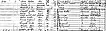 1861 Census for the Elms Abberley.jpg 1,490 × 445; 217 KB
-
 A Very Public Footpath - geograph.org.uk - 1482858.jpg 640 × 480; 248 KB
-
 A443 Abberley - geograph.org.uk - 4195450.jpg 640 × 457; 46 KB
-
 A443 at Elms Green - geograph.org.uk - 2744047.jpg 640 × 419; 62 KB
-
 A443 east entering Abberley - geograph.org.uk - 2742728.jpg 640 × 426; 87 KB
-

-
 Abberley Clock Tower (Viewed from Abberley Hill) - geograph.org.uk - 6527630.jpg 2,483 × 1,396; 683 KB
-

-
 Abberley Clock Tower - geograph.org.uk - 6526881.jpg 2,794 × 2,010; 1.31 MB
-
 Abberley Clock Tower - geograph.org.uk - 6527370.jpg 3,648 × 2,736; 3.88 MB
-
 Abberley Clock Tower - geograph.org.uk - 6527374.jpg 3,648 × 2,736; 4.21 MB
-
 Abberley Clock Tower - geograph.org.uk - 6527568.jpg 3,648 × 2,736; 2.67 MB
-
 Abberley Clock Tower - geograph.org.uk - 6725134.jpg 585 × 800; 111 KB
-
 Abberley Clock Tower - geograph.org.uk - 6750756.jpg 1,920 × 1,080; 809 KB
-
 Abberley Clock Tower - geograph.org.uk - 6750777.jpg 1,920 × 1,080; 1.02 MB
-
 Abberley Clock Tower - geograph.org.uk - 6911826.jpg 1,024 × 1,024; 492 KB
-
 Abberley Clocktower peeping over the trees - geograph.org.uk - 4556195.jpg 1,600 × 1,200; 421 KB
-
 Abberley Common in Worcestershire - geograph.org.uk - 6659928.jpg 800 × 513; 106 KB
-
 Abberley DSC00296.JPG 2,272 × 1,704; 708 KB
-
 Abberley Hall and the Clock Tower - geograph.org.uk - 6750754.jpg 1,920 × 1,080; 973 KB
-
 Abberley Hall and the Clock Tower - geograph.org.uk - 6879849.jpg 4,032 × 2,268; 2.58 MB
-
 Abberley Hall School - geograph.org.uk - 6725137.jpg 800 × 525; 103 KB
-
 Abberley Hill - geograph.org.uk - 6526177.jpg 2,560 × 1,440; 1.78 MB
-
 Abberley Hill - geograph.org.uk - 6527533.jpg 2,560 × 1,440; 1.73 MB
-
 Abberley Hill - geograph.org.uk - 6528324.jpg 2,560 × 1,440; 1.73 MB
-
 Abberley Hill - geograph.org.uk - 6528387.jpg 2,483 × 1,396; 652 KB
-
 Abberley Hill - geograph.org.uk - 6723794.jpg 1,920 × 1,080; 1.02 MB
-
 Abberley Hill - geograph.org.uk - 6750130.jpg 1,920 × 1,080; 1.02 MB
-
 Abberley Hill - geograph.org.uk - 6750135.jpg 1,920 × 1,080; 890 KB
-
 Abberley Hill - geograph.org.uk - 6750764.jpg 1,920 × 1,080; 1.11 MB
-
 Abberley Hill and the Clock Tower - geograph.org.uk - 6550417.jpg 2,560 × 1,440; 1.74 MB
-
 Abberley Parochial Primary School - geograph.org.uk - 6526145.jpg 2,560 × 1,440; 1.7 MB
-
 Abberley Parochial Primary School - geograph.org.uk - 6723659.jpg 2,048 × 1,360; 1.37 MB
-
 Abberley post office - geograph.org.uk - 3483417.jpg 1,024 × 768; 89 KB
-
 Abberley Reservoir - geograph.org.uk - 6526475.jpg 3,128 × 2,346; 1.81 MB
-
 Abberley Reservoir - geograph.org.uk - 6526487.jpg 3,076 × 2,307; 1.55 MB
-
 Abberley Reservoir - geograph.org.uk - 6526492.jpg 2,560 × 1,440; 1.87 MB
-
 Abberley Reservoir - geograph.org.uk - 6526498.jpg 2,560 × 1,440; 1.82 MB
-
 Abberley Reservoir - geograph.org.uk - 6527555.jpg 2,560 × 1,440; 1.8 MB
-
 Abberley Reservoir - geograph.org.uk - 6527573.jpg 3,648 × 2,736; 4.18 MB
-
 Abberley Reservoir - geograph.org.uk - 6750781.jpg 1,920 × 1,080; 1.06 MB
-
 Abberley Reservoir - geograph.org.uk - 6750782.jpg 1,920 × 1,080; 1.01 MB
-
 Abberley Reservoir - geograph.org.uk - 6750788.jpg 1,920 × 1,080; 1.06 MB
-
 Abberley village green - geograph.org.uk - 5104454.jpg 1,280 × 960; 385 KB
-
 Abberley Village Hall - geograph.org.uk - 6526147.jpg 2,419 × 1,360; 576 KB
-
 Abberley Village Hall - geograph.org.uk - 6666578.jpg 2,048 × 1,360; 1.15 MB
-
 Abberley village hall - geograph.org.uk - 6723784.jpg 1,920 × 1,080; 1,001 KB
-
 Abberley village hall - geograph.org.uk - 6750833.jpg 1,920 × 1,080; 1.05 MB
-
 Alpacas at Abberley - geograph.org.uk - 6528545.jpg 3,648 × 2,736; 4.41 MB
-
 Alpacas at Abberley - geograph.org.uk - 6528552.jpg 3,010 × 2,258; 1.36 MB
-
 Apple tree at Church Farm - geograph.org.uk - 6659895.jpg 800 × 578; 163 KB
-
 Approaching the centre of Abberley - geograph.org.uk - 419525.jpg 640 × 426; 118 KB
-
 Are you sure this is the way^ - geograph.org.uk - 2099980.jpg 640 × 480; 140 KB
-
 Autumn Colours, Gatehouse The Elms Hotel - geograph.org.uk - 4195451.jpg 640 × 448; 107 KB
-
 Avenue at Abberley village green - geograph.org.uk - 6750106.jpg 1,920 × 1,080; 1.05 MB
-
 B4202 junction with A443 - geograph.org.uk - 2744029.jpg 640 × 455; 104 KB
-
 Bell at St. Michael's Church (Abberley) - geograph.org.uk - 6528488.jpg 3,648 × 2,736; 3.7 MB
-
 Bench at Abberley village green - geograph.org.uk - 6750100.jpg 1,920 × 1,080; 1.08 MB
-
 Bench mark, St Mary's Church, Abberley - geograph.org.uk - 5104447.jpg 1,280 × 960; 451 KB
-
 Bend on B4202 near Beehive Farm - geograph.org.uk - 3276235.jpg 640 × 473; 61 KB
-
 Bringing In The Harvest, Abberley - geograph.org.uk - 1482855.jpg 640 × 480; 187 KB
-
 Brown Clee Hill (Viewed from Abberley) - geograph.org.uk - 6526672.jpg 2,560 × 1,440; 1.73 MB
-
 Canada Geese at Netherton House (Abberley) - geograph.org.uk - 6528347.jpg 3,648 × 2,736; 4.06 MB
-
 Celtic crosses in St. Mary's church (Abberley) - geograph.org.uk - 6840261.jpg 3,648 × 2,736; 4.72 MB
-
 Christmas trees at Abberley - geograph.org.uk - 6750829.jpg 1,920 × 1,080; 1.04 MB
-
 Christmas trees at Abberley - geograph.org.uk - 6750830.jpg 1,920 × 1,080; 990 KB
-

-
 Church Farm (Abberley) - geograph.org.uk - 6723814.jpg 2,048 × 1,360; 1.31 MB
-
 Church Farm (Abberley) - geograph.org.uk - 6723822.jpg 2,048 × 1,360; 1.38 MB
-
 Church Farm (Abberley) - geograph.org.uk - 6723885.jpg 2,048 × 1,360; 1.37 MB
-
 Church Farm (Abberley) - geograph.org.uk - 6750097.jpg 2,048 × 1,360; 1.35 MB
-
 Church Farm (Abberley) - geograph.org.uk - 6750103.jpg 2,048 × 1,360; 1,014 KB
-
 Church Farm and Lychgate at St. Mary's Church (Abberley) - geograph.org.uk - 6528616.jpg 3,648 × 2,736; 4.63 MB
-
 Church Farm, Abberley - geograph.org.uk - 5104444.jpg 1,280 × 960; 363 KB
-
 Church Farm, Abberley - geograph.org.uk - 6235864.jpg 3,323 × 2,209; 2.34 MB
-
 Churchyard at St. Mary's church (Abberley) - geograph.org.uk - 6723880.jpg 2,048 × 1,360; 1.42 MB
-
 Clows Top Road at Abberley Common - geograph.org.uk - 6659916.jpg 800 × 580; 111 KB
-
 Clows Top Road, Abberley - geograph.org.uk - 3490821.jpg 1,024 × 768; 110 KB
-
 Converted farm building at Town Farm - geograph.org.uk - 6359320.jpg 800 × 533; 157 KB
-
 Countryside at Abberley - geograph.org.uk - 6526647.jpg 2,560 × 1,440; 1.65 MB
-
 Countryside at Abberley - geograph.org.uk - 6526797.jpg 2,560 × 1,440; 1.52 MB
-
 Countryside at Abberley - geograph.org.uk - 6528510.jpg 2,560 × 1,440; 1.86 MB
-
 Countryside at Abberley - geograph.org.uk - 6528512.jpg 2,560 × 1,440; 1.65 MB
-
 Countryside near Abberley - geograph.org.uk - 6725125.jpg 800 × 504; 101 KB
-
 Countryside view near Abberley - geograph.org.uk - 6660088.jpg 800 × 534; 97 KB
-
 Damson Orchard nr. Bowling Green Farm - geograph.org.uk - 1244608.jpg 640 × 480; 221 KB
-
 Deer at Five Ways - geograph.org.uk - 6725154.jpg 800 × 546; 102 KB
-
 Deer by the track to Abberley Clock Tower - geograph.org.uk - 6527458.jpg 2,374 × 1,335; 1 MB
-
 Deer farming - geograph.org.uk - 3729767.jpg 1,024 × 680; 293 KB
-
 Door to St. Michael's Church (Abberley) - geograph.org.uk - 6528486.jpg 3,648 × 2,736; 4.73 MB
-
 Doorway at St. Michael's Church (Abberley) - geograph.org.uk - 6528430.jpg 3,648 × 2,736; 4.62 MB
-
 Doorway at St. Michael's Church (Abberley) - geograph.org.uk - 6528470.jpg 3,648 × 2,736; 4.79 MB
-

-
 Down the hill into Abberley - geograph.org.uk - 3276227.jpg 640 × 420; 60 KB
-
 Drive to Hill Farm - geograph.org.uk - 3731486.jpg 1,024 × 680; 214 KB
-
 Ducks in the lake at Netherton House (Abberley) - geograph.org.uk - 6528343.jpg 3,128 × 1,777; 1.22 MB
-
 Elbatch Lodge (geograph 7132524).jpg 1,600 × 1,069; 464 KB
-
 Entrance to Abberley Hall - geograph.org.uk - 4406852.jpg 1,600 × 1,154; 441 KB
-
 Entrance to Abberley Village Green - geograph.org.uk - 6528589.jpg 3,648 × 2,736; 4.73 MB
-

-
 Farm by Abberley Hall School - geograph.org.uk - 6527449.jpg 2,560 × 1,440; 1.64 MB
-
 Farm Track - geograph.org.uk - 907713.jpg 640 × 421; 75 KB
-
 Farmed deer at Abberley - geograph.org.uk - 3729614.jpg 1,024 × 680; 222 KB
-
 Farmland at Abberley - geograph.org.uk - 6526489.jpg 3,648 × 2,736; 4.83 MB
-
 Farmland at Shavers End - geograph.org.uk - 416110.jpg 640 × 426; 134 KB
-
 Farmland near Netherton Farm - geograph.org.uk - 6656748.jpg 800 × 540; 116 KB
-
 Farmland north of Reynolds Farm - geograph.org.uk - 5746260.jpg 1,024 × 680; 241 KB
-
 Field at Abberley - geograph.org.uk - 6526257.jpg 2,560 × 1,440; 1.36 MB
-
 Field at Abberley - geograph.org.uk - 6528368.jpg 2,560 × 1,440; 1.72 MB
-
 Field at Abberley - geograph.org.uk - 6750795.jpg 1,920 × 1,080; 939 KB
-
 Field by the Abberley Circular Walk - geograph.org.uk - 6528380.jpg 2,560 × 1,440; 1.73 MB
-
 Fingerposts by Netherton House (Abberley) - geograph.org.uk - 6528357.jpg 3,648 × 2,736; 4.31 MB
-
 Fingerposts by Netherton House (Abberley) - geograph.org.uk - 6528360.jpg 3,648 × 2,736; 4.74 MB
-
 Footpath above Meneatt Wood - geograph.org.uk - 4293809.jpg 800 × 531; 151 KB
-
 Footpath marker on the Abberley Circular Walk - geograph.org.uk - 6750111.jpg 1,920 × 1,080; 972 KB
-
 Footpath marker on the Abberley Circular Walk - geograph.org.uk - 6750112.jpg 2,048 × 1,360; 1.33 MB
-
 Footpath to Abberley Post Office - geograph.org.uk - 1401928.jpg 640 × 480; 99 KB
-
 Footpath to Abberley village - geograph.org.uk - 2099963.jpg 640 × 480; 103 KB
-
 Footpath to Wynniattes Way (Abberley) - geograph.org.uk - 6528555.jpg 3,648 × 2,736; 4.55 MB
-
 Former Stables (Abberley) - geograph.org.uk - 6528495.jpg 3,648 × 2,736; 4.34 MB
-
 Gate on the Abberley Circular Walk - geograph.org.uk - 6526359.jpg 3,128 × 2,346; 2.26 MB
-
 Gate on the Abberley Circular Walk - geograph.org.uk - 6526372.jpg 3,128 × 2,346; 2.54 MB
-
 Gate to St. Mary's church (Abberley) - geograph.org.uk - 6840263.jpg 3,648 × 2,736; 4.59 MB
-
 Gatehouse For The Elms Hotel - geograph.org.uk - 1490126.jpg 640 × 480; 107 KB
-
 Gates, Abberley - geograph.org.uk - 2603980.jpg 640 × 421; 256 KB
-
 Hay For Sale - geograph.org.uk - 1482877.jpg 640 × 480; 81 KB
-
 Hazeland Barn (Abberley) - geograph.org.uk - 6528385.jpg 2,560 × 1,440; 1.74 MB
-
 High In Abberley - geograph.org.uk - 1174392.jpg 640 × 428; 83 KB
-
 Hill Farm (Abberley) - geograph.org.uk - 6526543.jpg 2,459 × 1,383; 730 KB
-
 Hillside Off Netherton Road - geograph.org.uk - 1482889.jpg 640 × 480; 222 KB
-

-
 Houses at Abberley - geograph.org.uk - 6528493.jpg 3,648 × 2,736; 4.07 MB
-
 Houses in Suffolk Lane (Abberley) - geograph.org.uk - 6723704.jpg 1,920 × 1,080; 1,010 KB
-
 Houses on a bend and junction in Abberley - geograph.org.uk - 3483424.jpg 1,024 × 512; 102 KB
-
 Information Board at Abberley Village Hall - geograph.org.uk - 6526149.jpg 3,648 × 2,736; 4.62 MB
-
 Jacob sheep at Netherton House (Abberley) - geograph.org.uk - 6750125.jpg 2,048 × 1,360; 1.39 MB
-
 Junction for Cleobury Mortimer near Abberley - geograph.org.uk - 3483402.jpg 1,024 × 1,024; 261 KB
-
 Junction of 'The Common' with the main A443 - geograph.org.uk - 3335502.jpg 2,112 × 2,816; 1.23 MB
-
 Keepers Cottage (Abberley) - geograph.org.uk - 6526696.jpg 2,807 × 2,114; 888 KB
-
 Lake at Netherton House (Abberley) - geograph.org.uk - 6528337.jpg 3,648 × 2,736; 4.8 MB
-
 Lake at Netherton House (Abberley) - geograph.org.uk - 6528340.jpg 3,648 × 2,736; 4.7 MB
-
 Lake at Netherton House (Abberley) - geograph.org.uk - 6750129.jpg 1,920 × 1,080; 1.03 MB
-
 Lane at Abberley - geograph.org.uk - 6526191.jpg 3,648 × 2,736; 3.84 MB
-
 Lane at Abberley - geograph.org.uk - 6528506.jpg 3,648 × 2,736; 4.7 MB
-
 Lane at Abberley - geograph.org.uk - 6528522.jpg 3,648 × 2,736; 4.83 MB
-
 Lane at Abberley - geograph.org.uk - 6723767.jpg 1,920 × 1,080; 1.06 MB
-
 Lane at Abberley - geograph.org.uk - 6750831.jpg 1,920 × 1,080; 1.03 MB
-
 Lane at Abberley Village - geograph.org.uk - 6659874.jpg 800 × 582; 162 KB
-
 Lane To Abberley At Brookside Cottage - geograph.org.uk - 1482884.jpg 640 × 480; 276 KB
-
 Lane to Abberley Village Hall - geograph.org.uk - 6526152.jpg 3,648 × 2,736; 4.39 MB
-
 Lane to the B4202 Road (Abberley) - geograph.org.uk - 6526166.jpg 3,648 × 2,736; 4.21 MB
-
 Lay by on Bend on B4202 - geograph.org.uk - 3276241.jpg 640 × 356; 41 KB
-
 Lay-by on B4202 north of Abberley - geograph.org.uk - 3488883.jpg 1,024 × 512; 63 KB
-
 Lodge near Abberley - geograph.org.uk - 2103396.jpg 534 × 640; 167 KB
-
 Lychgate at St. Mary's Church (Abberley) - geograph.org.uk - 6528596.jpg 3,648 × 2,736; 4.56 MB
-
 Lychgate at St. Mary's church (Abberley) - geograph.org.uk - 6723883.jpg 2,048 × 1,360; 1.41 MB
-
 Man's Wood (Abberley) - geograph.org.uk - 6527517.jpg 3,648 × 2,736; 4.66 MB
-
 Map The Elms Abberley 1813.jpg 1,200 × 710; 249 KB
-
 Monument at St. Michael's Church (Abberley) - geograph.org.uk - 6528455.jpg 3,648 × 2,736; 4.79 MB
-
 Natherton Road - geograph.org.uk - 5746266.jpg 1,024 × 680; 285 KB
-
 Neatly Mown Lawn Near Elms Green - geograph.org.uk - 1490137.jpg 640 × 480; 183 KB
-
 Netherton House (Abberley) - geograph.org.uk - 6528332.jpg 3,648 × 2,736; 3.66 MB
-
 Netherton House (Abberley) - geograph.org.uk - 6528336.jpg 2,736 × 3,648; 4.79 MB
-
 Netherton House (Abberley) - geograph.org.uk - 6528351.jpg 3,648 × 2,736; 4.06 MB
-
 Netherton House (Abberley) - geograph.org.uk - 6750128.jpg 2,048 × 1,360; 1.32 MB
-
 Netherton House and the Abberley Circular Walk - geograph.org.uk - 6528325.jpg 2,560 × 1,440; 1.71 MB
-
 Netherton House and the Abberley Circular Walk - geograph.org.uk - 6528333.jpg 3,648 × 2,736; 4.58 MB
-
 Netherton House and the Abberley Circular Walk - geograph.org.uk - 6750131.jpg 2,048 × 1,360; 1.2 MB
-
 Netherton Lane in Abberley village - geograph.org.uk - 6659571.jpg 800 × 597; 148 KB
-
 Netherton Road (Abberley) - geograph.org.uk - 6528366.jpg 3,648 × 2,736; 4.36 MB
-
 Netherton Road (Abberley) - geograph.org.uk - 6528390.jpg 3,648 × 2,736; 4.75 MB
-
 Netherton Road (Abberley) - geograph.org.uk - 6750119.jpg 2,048 × 1,360; 1.37 MB
-
 Netherton Road (Abberley) - geograph.org.uk - 6750121.jpg 2,048 × 1,360; 1.41 MB
-
 Netherton Road heading north - geograph.org.uk - 6656753.jpg 800 × 625; 180 KB
-
 Netherton Road heading south - geograph.org.uk - 6656764.jpg 800 × 600; 153 KB
-
 Notice Board at St. Michael's Church (Abberley) - geograph.org.uk - 6528420.jpg 3,648 × 2,736; 4.28 MB
-
 Old Milestone, A443, Stockton Road, Elms Green (geograph 6599525).jpg 392 × 521; 177 KB
-
 One Acre Cottage (Abberley) - geograph.org.uk - 6750110.jpg 2,048 × 1,360; 1.37 MB
-
 Path across the Abberley Village Green - geograph.org.uk - 6659890.jpg 800 × 600; 160 KB
-

-
 Path around St. Mary's church (Abberley) - geograph.org.uk - 6840272.jpg 3,648 × 2,736; 4.47 MB
-
 Path at Abberley village green - geograph.org.uk - 6750095.jpg 2,048 × 1,360; 1.46 MB
-
 Path crossing field - geograph.org.uk - 2939404.jpg 2,048 × 1,536; 649 KB
-
 Path from Haseland Farm - geograph.org.uk - 2939389.jpg 2,048 × 1,536; 675 KB
-
 Path from Netherton Lane - geograph.org.uk - 2939319.jpg 1,536 × 2,048; 670 KB
-
 Path near trees - geograph.org.uk - 2939346.jpg 2,048 × 1,536; 705 KB
-
 Path on footbridge - geograph.org.uk - 2939357.jpg 2,048 × 1,536; 641 KB
-
 Path to Abberley Village - geograph.org.uk - 2939332.jpg 2,048 × 1,536; 672 KB
-
 Path to Manor Arms - geograph.org.uk - 1401952.jpg 640 × 480; 104 KB
-
 Path to Suffolk Lane - geograph.org.uk - 2939369.jpg 2,048 × 1,536; 687 KB
-
 Plaque on the trig point at Abberley Hill - geograph.org.uk - 6527614.jpg 3,648 × 2,736; 4.48 MB
-
 Plaque on the trig point at Abberley Hill - geograph.org.uk - 6750762.jpg 1,920 × 1,080; 975 KB
-
 Pond at Netherton Farm - geograph.org.uk - 6656757.jpg 800 × 573; 191 KB
-
 Pond for cattle - geograph.org.uk - 2939416.jpg 2,048 × 1,536; 652 KB
-
 Postbox in the Village, Abberley - geograph.org.uk - 6659668.jpg 800 × 610; 167 KB
-

-
 Pylon at Abberley - geograph.org.uk - 6723645.jpg 1,920 × 1,080; 1,002 KB
-
 Pylons at Abberley - geograph.org.uk - 6526018.jpg 2,560 × 1,440; 1.41 MB
-
 Pylons at Abberley - geograph.org.uk - 6526198.jpg 2,560 × 1,440; 1.69 MB


_-_geograph.org.uk_-_6527630.jpg)
_-_geograph.org.uk_-_5904233.jpg)


_-_geograph.org.uk_-_6528488.jpg)


_-_geograph.org.uk_-_6526672.jpg)
_-_geograph.org.uk_-_6528347.jpg)
_-_geograph.org.uk_-_6840261.jpg)


_-_geograph.org.uk_-_6723814.jpg)
_-_geograph.org.uk_-_6723822.jpg)
_-_geograph.org.uk_-_6723885.jpg)
_-_geograph.org.uk_-_6750097.jpg)
_-_geograph.org.uk_-_6750103.jpg)
_-_geograph.org.uk_-_6528616.jpg)


_-_geograph.org.uk_-_6723880.jpg)


_-_geograph.org.uk_-_6528486.jpg)
_-_geograph.org.uk_-_6528430.jpg)
_-_geograph.org.uk_-_6528470.jpg)


_-_geograph.org.uk_-_6528343.jpg)
.jpg)


_-_geograph.org.uk_-_6528357.jpg)
_-_geograph.org.uk_-_6528360.jpg)


_-_geograph.org.uk_-_6528555.jpg)
_-_geograph.org.uk_-_6528495.jpg)


_-_geograph.org.uk_-_6840263.jpg)


_-_geograph.org.uk_-_6528385.jpg)

_-_geograph.org.uk_-_6526543.jpg)


_-_geograph.org.uk_-_6723704.jpg)


_-_geograph.org.uk_-_6750125.jpg)


_-_geograph.org.uk_-_6526696.jpg)
_-_geograph.org.uk_-_6528337.jpg)
_-_geograph.org.uk_-_6528340.jpg)
_-_geograph.org.uk_-_6750129.jpg)


_-_geograph.org.uk_-_6526166.jpg)


_-_geograph.org.uk_-_6528596.jpg)
_-_geograph.org.uk_-_6723883.jpg)
_-_geograph.org.uk_-_6527517.jpg)

_-_geograph.org.uk_-_6528455.jpg)


_-_geograph.org.uk_-_6528332.jpg)
_-_geograph.org.uk_-_6528336.jpg)
_-_geograph.org.uk_-_6528351.jpg)
_-_geograph.org.uk_-_6750128.jpg)


_-_geograph.org.uk_-_6528366.jpg)
_-_geograph.org.uk_-_6528390.jpg)
_-_geograph.org.uk_-_6750119.jpg)
_-_geograph.org.uk_-_6750121.jpg)


_-_geograph.org.uk_-_6528420.jpg)
.jpg)
_-_geograph.org.uk_-_6750110.jpg)


_-_geograph.org.uk_-_6840272.jpg)


