Category:Aachener Straße 378-390 (Köln)
Jump to navigation
Jump to search
| Object location | | View all coordinates using: OpenStreetMap |
|---|
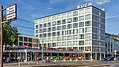
This is the category for an architectural monument.
It is on the list of cultural monuments of Köln, no. 6433.
It is on the list of cultural monuments of Köln, no. 6433.
Media in category "Aachener Straße 378-390 (Köln)"
The following 4 files are in this category, out of 4 total.
-
 Köln-Braunsfeld Aachener Strasse 378-390 Bild 1 Denkmal 6433.JPG 3,872 × 2,592; 744 KB
-
 Köln-Braunsfeld Aachener Strasse 378-390 Bild 2 Denkmal 6433.JPG 3,872 × 2,592; 833 KB
-
 Köln-Braunsfeld Aachener Strasse 378-390 Bild 3 Denkmal 6433.JPG 3,872 × 2,592; 812 KB
-
 Wohn- und Geschäftshaus Aachener Str. 378-390, Köln-7935.jpg 4,233 × 2,381; 7.78 MB


