Category:A Wagoner of the South Sea describeing the sea coast from acapulco to Albemarle isle (1685) (RMG)
Jump to navigation
Jump to search
Media in category "A Wagoner of the South Sea describeing the sea coast from acapulco to Albemarle isle (1685) (RMG)"
The following 150 files are in this category, out of 150 total.
-
 (Coaque (and) Borrachos) RMG F1860.tiff 6,548 × 5,388; 100.94 MB
-
 A description of Guamalula and the Indians town RMG F1809.tiff 6,656 × 5,328; 101.46 MB
-
 A description of the Citty of Lima and Callao RMG F1894.tiff 6,520 × 5,437; 101.42 MB
-
 A description of the Gulf of Ampall RMG F1824.tiff 6,613 × 5,332; 100.88 MB
-
 A description of the Gulf of Papagajo RMG F1830.tiff 6,634 × 5,398; 102.45 MB
-
 A description of the old town and the port of realejo RMG F1826.tiff 6,675 × 5,385; 102.84 MB
-
 A description of the Perle Islands RMG F1848.tiff 6,643 × 5,433; 103.26 MB
-
 A description of the plantations and setlements in the valley of tepaca RMG F1823.tiff 6,636 × 5,314; 100.89 MB
-
 A description of the plantations in the valley of paneca RMG F1820.tiff 6,600 × 5,314; 100.34 MB
-
 A description of the port of Coquimbo; heradura and Tongoy RMG F1924.tiff 6,680 × 5,436; 103.89 MB
-
 A description of the River of Baldivia RMG F1939.tiff 6,656 × 5,298; 100.89 MB
-
 A description of the sea coast from mta puercos to bad point RMG F1842.tiff 6,644 × 5,409; 102.82 MB
-
 A description of the sea coast from ye point of burica to c st francis RMG F1849.tiff 6,644 × 5,410; 102.84 MB
-
 A description of the sweet Gulf RMG F1837 (cropped).tiff 2,600 × 2,580; 19.19 MB
-
 A description of the sweet Gulf RMG F1837.tiff 6,645 × 5,425; 103.14 MB
-
 A description of ye sea coast from pt Galera to alcatraces RMG F1804.tiff 6,716 × 5,280; 101.45 MB
-
 A description of ye sea coast from the pt of Garachine to chame RMG F1846.tiff 6,669 × 5,427; 103.55 MB
-
 A generall map of this following Spanish manuscript RMG E9643.tiff 3,600 × 2,213; 22.79 MB
-
 Acapulco RMG E9644.tiff 3,600 × 2,225; 22.92 MB
-
 Alcama RMG F1914.tiff 6,591 × 5,434; 102.47 MB
-
 Amilpas RMG F1815.tiff 6,694 × 5,373; 102.9 MB
-
 Anabacas RMG F1817.tiff 6,648 × 5,314; 101.07 MB
-
 Anegadas RMG F1853.tiff 6,585 × 5,400; 101.74 MB
-
 Ariquipq (and) Valley of Hillo RMG F1908.tiff 6,614 × 5,394; 102.07 MB
-
 Atiquipa RMG F1904.tiff 6,554 × 5,448; 102.16 MB
-
 Bahia de Ancon de Sardinas RMG F1857.tiff 6,596 × 5,387; 101.66 MB
-
 Bahia San Mateo RMG F1858.tiff 6,539 × 5,424; 101.47 MB
-
 Barranca RMG F1890.tiff 6,543 × 5,458; 102.17 MB
-
 Bernall RMG F1813.tiff 6,668 × 5,268; 100.5 MB
-
 Biobio (and) Labapi RMG F1936.tiff 6,602 × 5,314; 100.37 MB
-
 Bonaventura RMG F1855.tiff 6,573 × 5,385; 101.27 MB
-
 Caleto RMG F1807.tiff 6,608 × 5,304; 100.28 MB
-
 Caman (and) Aquilca RMG F1906.tiff 6,531 × 5,432; 101.5 MB
-
 Camba RMG F1909.tiff 6,554 × 5,423; 101.69 MB
-
 Canette RMG F1898.tiff 6,520 × 5,447; 101.61 MB
-
 Cape Guyones RMG F1832.tiff 6,621 × 5,366; 101.65 MB
-
 Caraputo RMG F1862.tiff 6,596 × 5,375; 101.43 MB
-
 Carnero (and) Tucapel RMG F1937.tiff 6,686 × 5,332; 101.99 MB
-
 Caxaoma (and) Rapell RMG F1931.tiff 6,578 × 5,319; 100.1 MB
-
 Cazma RMG F1885.tiff 6,507 × 5,495; 102.3 MB
-
 Chala RMG F1903.tiff 6,496 × 5,504; 102.29 MB
-
 Chancay RMG F1893.tiff 6,543 × 5,456; 102.13 MB
-
 Chancayllo RMG F1892.tiff 6,519 × 5,463; 101.89 MB
-
 Cherepe RMG F1876.tiff 6,249 × 5,214; 93.22 MB
-
 Chicama RMG F1878.tiff 6,520 × 5,422; 101.14 MB
-
 Chilay RMG F1907.tiff 6,579 × 5,410; 101.83 MB
-
 Chilca (and) Asia RMG F1897.tiff 6,520 × 5,416; 101.03 MB
-
 Chilca RMG F1896.tiff 6,529 × 5,512; 102.96 MB
-
 Chimbote RMG F1883.tiff 6,507 × 5,495; 102.3 MB
-
 Chirenall (and) Copiapo RMG F1920.tiff 6,590 × 5,313; 100.17 MB
-
 Cojimies RMG F1859.tiff 6,536 × 5,401; 101 MB
-
 Corientes RMG F1854.tiff 6,560 × 5,413; 101.59 MB
-
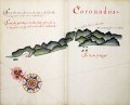 Coronados RMG F1835.tiff 6,632 × 5,349; 101.49 MB
-
 Coronados RMG F1941.tiff 6,718 × 5,336; 102.56 MB
-
 Encomienda (and) Soconusco RMG F1814.tiff 6,644 × 5,280; 100.37 MB
-
 English Gulf RMG F1942.tiff 6,612 × 5,290; 100.07 MB
-
 Escondido RMG F1805.tiff 6,692 × 5,280; 101.09 MB
-
 Eten RMG F1873.tiff 6,520 × 5,426; 101.22 MB
-
 Garachine views RMG F1850.tiff 6,621 × 5,344; 101.23 MB
-
 Guacho RMG F1891.tiff 6,520 × 5,482; 102.26 MB
-
 Guanapa RMG F1881.tiff 6,554 × 5,523; 103.56 MB
-
 Guanbacho RMG F1884.tiff 6,530 × 5,500; 102.75 MB
-
 Guancharpure (and) Itata RMG F1934.tiff 6,614 × 5,341; 101.07 MB
-
 Guarmey RMG F1888.tiff 6,509 × 5,432; 101.16 MB
-
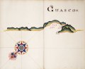 Guasco RMG F1923.tiff 6,628 × 5,407; 102.53 MB
-
 Guasco RMG L8009.tiff 6,000 × 4,500; 77.25 MB
-
 Guatimala RMG F1818.tiff 6,658 × 5,366; 102.22 MB
-
 Guatulco RMG F1808.tiff 6,644 × 5,316; 101.05 MB
-
 Guayaquil R RMG F1867.tiff 6,581 × 5,408; 101.82 MB
-
 Heradura (and) Conception RMG F1935.tiff 6,711 × 5,368; 103.07 MB
-
 Heradura (and) Governadore RMG F1927.tiff 6,631 × 5,365; 101.78 MB
-
 Hill of Leon RMG F1829.tiff 6,657 × 5,373; 102.33 MB
-
 Isle of Juan Fernandes RMG F1945.tiff 6,756 × 5,282; 102.1 MB
-
 Isles of Juan Fernandes RMG F1944.tiff 4,949 × 7,222; 102.26 MB
-
 Jaquey RMG F1889.tiff 6,538 × 5,433; 101.63 MB
-
 Juniall RMG F1922.tiff 6,594 × 5,321; 100.38 MB
-
 Laligua RMG F1928.tiff 6,625 × 5,395; 102.26 MB
-
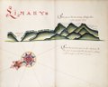
 Lima RMG F1895.tiff 6,519 × 5,450; 101.65 MB
-
 Limary RMG F1926.tiff 6,593 × 5,338; 100.69 MB
-
 Loa (and) Algodonales RMG F1913.tiff 6,576 × 5,358; 100.81 MB
-
 Majillones RMG F1915.tiff 6,578 × 5,352; 100.72 MB
-
 Malaca RMG F1869.tiff 6,555 × 5,410; 101.46 MB
-
 Mancora RMG F1868.tiff 6,507 × 5,421; 100.92 MB
-
 Manta RMG F1864.tiff 6,592 × 5,382; 101.5 MB
-
 Masias (and) Galera RMG F1806.tiff 6,647 × 5,321; 101.19 MB
-
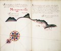 Mongoncilla RMG F1887.tiff 6,500 × 5,445; 101.26 MB
-
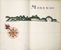 Moreno RMG F1916.tiff 6,625 × 5,419; 102.71 MB
-
 Mosquitos (and) Angadico RMG F1812.tiff 6,656 × 5,318; 101.27 MB
-
 Naguala RMG F1802.tiff 6,632 × 5,280; 100.18 MB
-
 Nastras RMG F1917.tiff 6,614 × 5,432; 102.79 MB
-
 Navidad (and) Maule RMG F1933.tiff 6,672 × 5,418; 103.42 MB
-
 Ocana RMG F1905.tiff 6,496 × 5,392; 100.21 MB
-
 Osorno (and) Carimapo RMG F1940.tiff 6,636 × 5,322; 101.04 MB
-
 Pacasmayo (and) Malabrigo RMG F1877.tiff 6,520 × 5,442; 101.51 MB
-
 Paneca (and) Sonsonate RMG F1819.tiff 6,646 × 5,361; 101.94 MB
-
 Papudo (and) Quintera RMG F1929.tiff 6,484 × 5,226; 96.95 MB
-
 Paraca RMG F1900.tiff 6,531 × 5,409; 101.07 MB
-
 Part of Panama bay RMG F1845.tiff 6,609 × 5,322; 100.63 MB
-
 Passao RMG F1861.tiff 6,548 × 5,363; 100.47 MB
-
 Picoaza RMG F1865.tiff 6,568 × 5,409; 101.64 MB
-
 Pisagoa (and) Yqueque RMG F1912.tiff 6,598 × 5,379; 101.54 MB
-
 Port of mount quemado RMG F1901.tiff 6,554 × 5,474; 102.64 MB
-
 Punta Chame and La Chorrera RMG F1844.tiff 6,614 × 5,393; 102.05 MB
-
 Quemado RMG F1852.tiff 6,632 × 5,398; 102.42 MB
-
 Quillota (and) Valpariso RMG F1930.tiff 6,631 × 5,315; 100.83 MB
-
 Roldan RMG F1825.tiff 6,644 × 5,354; 101.77 MB
-
 Rosario RMG F1856.tiff 6,572 × 5,412; 101.76 MB
-
 Salado (and) Totoral RMG F1921.tiff 6,544 × 5,397; 101.05 MB
-
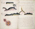
 Sapoticlan (and) Sacatepeque RMG F1816.tiff 6,658 × 5,300; 100.96 MB
-
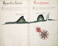
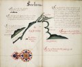 Sechura RMG F1871.tiff 6,533 × 5,398; 100.89 MB
-
 St Hellena RMG F1866.tiff 6,580 × 5,383; 101.34 MB
-
 St Lorenzo RMG F1863.tiff 6,572 × 5,375; 101.06 MB
-
 St Salvador RMG F1822.tiff 6,658 × 5,349; 101.89 MB
-
 St. George RMG F1918.tiff 6,617 × 5,348; 101.25 MB
-
 Sta Domingo RMG F1899.tiff 6,554 × 5,461; 102.4 MB
-
 Straits of Magellan and Le Maire RMG F1943.tiff 6,768 × 5,350; 103.59 MB
-
 Taclamama RMG F1803.tiff 6,704 × 5,292; 101.5 MB
-
 Teguantepeque RMG F1811.tiff 6,676 × 5,338; 101.96 MB
-
 Telica RMG F1828.tiff 6,599 × 5,391; 101.78 MB
-
 The bay of Chiriqui RMG F1838.tiff 6,644 × 5,422; 103.06 MB
-
 The bay of Colan and port of Paita RMG F1870.tiff 6,520 × 5,422; 101.14 MB
-
 The bay of Escoria described RMG F1843.tiff 6,645 × 5,430; 103.23 MB
-
 The Bay of Guayaquil RMG E9646.tiff 3,600 × 2,322; 23.92 MB
-
 The bay of phillipina RMG F1840.tiff 6,645 × 5,430; 103.23 MB
-
 The bay of Pueblo Nueba RMG F1839.tiff 6,680 × 5,447; 104.1 MB
-
 The bay of Saints RMG F1882.tiff 6,554 × 5,499; 103.11 MB
-
 The Bay of Snakes RMG F1831.tiff 6,633 × 5,418; 102.82 MB
-
 The Gulf of Nicoya described RMG E9645.tiff 3,600 × 2,252; 23.2 MB
-
 The Gulf of Vallona RMG F1847.tiff 6,632 × 5,423; 102.9 MB
-
 The high land of cano and Candish bay RMG F1836.tiff 6,633 × 5,388; 102.25 MB
-
 The high land of cape blanco RMG F1834.tiff 6,645 × 5,384; 102.36 MB
-
 The high land of cape Guyones RMG F1833.tiff 6,645 × 5,395; 102.57 MB
-
 The Island of Chiloe RMG E9647.tiff 3,600 × 2,239; 23.06 MB
-
 The point of meriato RMG F1841.tiff 6,638 × 5,412; 102.78 MB
-
 The port of Arica RMG F1910.tiff 6,602 × 5,446; 102.87 MB
-
 The Port of Pinas RMG F1851.tiff 6,620 × 5,386; 102.01 MB
-
 The valley of Yca RMG F1902.tiff 6,530 × 5,424; 101.33 MB
-
 Tirao (and) Tolten RMG F1938.tiff 6,663 × 5,333; 101.66 MB
-
 Tonela (and) Moncalco RMG F1821.tiff 6,706 × 5,336; 102.38 MB
-
 Tongoy RMG F1925.tiff 6,680 × 5,411; 103.41 MB
-
 Topo Calma RMG F1932.tiff 6,684 × 5,417; 103.59 MB
-
 Tosta RMG F1827.tiff 6,646 × 5,349; 101.71 MB
-
 Truxilo RMG F1880.tiff 6,533 × 5,435; 101.59 MB
-
 Vetas RMG F1919.tiff 6,689 × 5,393; 103.21 MB
-
 Views of Cerro Mongon RMG F1886.tiff 6,507 × 5,395; 100.44 MB
-
 Views of Isla Lobos and mountains RMG F1874.tiff 6,500 × 5,455; 101.44 MB
-
 Views of Silla de Paita and Punta Aguja RMG F1872.tiff 6,531 × 5,400; 100.9 MB
-
 Views of Trujillo and Carettas RMG F1879.tiff 6,508 × 5,410; 100.73 MB
-
 Vitor (and) Camarones RMG F1911.tiff 6,567 × 5,381; 101.1 MB
-
 Zana RMG F1875.tiff 6,566 × 5,447; 102.32 MB