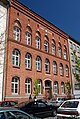
Category:7 Smoleńsk street in Kraków
Jump to navigation
Jump to search
| Object location | | View all coordinates using: OpenStreetMap |
|---|
building in Kraków, Poland .JPG) | |||||
| Upload media | |||||
| Instance of | |||||
|---|---|---|---|---|---|
| Location | Kraków, Lesser Poland Voivodeship, Poland | ||||
| Street address |
| ||||
| Heritage designation |
| ||||
| Inception |
| ||||
| Significant event |
| ||||
 | |||||
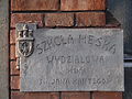
Polski: Dawna szkoła miejska. Obecnie szkoła podstawowa nr 4 w Krakowie im. Romualda Traugutta.
| Address |
|
Media in category "7 Smoleńsk street in Kraków"
The following 11 files are in this category, out of 11 total.
-
 617358 Kraków Smoleńsk 7 szkoła 1.JPG 4,896 × 3,672; 6.59 MB
-
 Kraków, Smoleńsk 7 (1).JPG 4,288 × 3,216; 3.83 MB
-
 Kraków, Smoleńsk 7 (2).JPG 4,288 × 3,216; 3.23 MB
-
 Kraków, Smoleńsk 7 (3).JPG 4,288 × 3,216; 3.49 MB
-
 Kraków, Smoleńsk 7 (4).JPG 3,216 × 4,288; 2.86 MB
-
 Kraków, Szkoła miejska, ob. szkoła podstawowa nr 4.jpg 3,000 × 4,000; 6.46 MB
-
 Kraków, ul. Smoleńsk 7 (2).JPG 4,320 × 3,240; 4.03 MB
-
 Kraków, ul. Smoleńsk 7 (3).JPG 4,320 × 3,240; 3.98 MB
-
 Kraków, ul. Smoleńsk 7.JPG 4,320 × 3,240; 4.26 MB
-
 School by Moraczewski, Kraków.JPG 1,944 × 2,896; 4.27 MB
-
 SzkołaMiejska-UlicaSmoleńsk7-POL, Kraków.jpg 4,000 × 3,600; 6.58 MB

.JPG)
.JPG)
.JPG)

.JPG)
.JPG)


