Category:63 Rodney Street, Liverpool
Jump to navigation
Jump to search
| Object location | | View all coordinates using: OpenStreetMap |
|---|
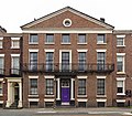
The centre building of a Grade II listed terrace of thirteen late 18th century houses in brick with stone dressings and slate roofs.
Media in category "63 Rodney Street, Liverpool"
The following 2 files are in this category, out of 2 total.
-
 63 Rodney Street, Liverpool 2020.jpg 3,514 × 3,075; 11.87 MB
-
 63 Rodney Street, Liverpool.jpg 1,180 × 1,511; 1.08 MB

