Category:57 Parr Street, Liverpool
Jump to navigation
Jump to search
| Object location | | View all coordinates using: OpenStreetMap |
|---|
building in Liverpool, Merseyside, England, UK .jpg) | |||||
| Upload media | |||||
| Instance of | |||||
|---|---|---|---|---|---|
| Named after |
| ||||
| Location | Liverpool, Merseyside, North West England, England | ||||
| Owned by |
| ||||
| Heritage designation |
| ||||
 | |||||
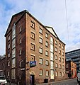
Grade II listed brick warehouse built c.1799 for Thomas Parr, a merhant, banker and slave trader. Adjacent to his town house.
Media in category "57 Parr Street, Liverpool"
The following 4 files are in this category, out of 4 total.
-
 57 Parr Street, Liverpool (geograph 2869351).jpg 466 × 640; 202 KB
-
 57 Parr Street, Liverpool 1.jpg 2,921 × 4,496; 7.76 MB
-
 57 Parr Street, Liverpool 2.jpg 2,934 × 4,427; 7.44 MB
-
 57 Parr Street, Liverpool 3.jpg 2,923 × 3,103; 5.63 MB


