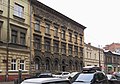
Category:54 Długa Street in Kraków
Jump to navigation
Jump to search
| Object location | | View all coordinates using: OpenStreetMap |
|---|
 | |||||
| Upload media | |||||
| Instance of | |||||
|---|---|---|---|---|---|
| Location | Kraków, Lesser Poland Voivodeship, Poland | ||||
| Street address |
| ||||
| Heritage designation |
| ||||
| Inception |
| ||||
 | |||||
Media in category "54 Długa Street in Kraków"
The following 10 files are in this category, out of 10 total.
-
 Długa 54 by Talowski.jpg 2,136 × 1,704; 2.14 MB
-
 Długa 54 Kraków 01.jpg 3,910 × 2,732; 2.24 MB
-
 Długa 54 kraków zbliżenie.JPG 2,400 × 2,952; 1.09 MB
-
 Krakow kamienica Dluga 54.jpg 3,456 × 5,184; 8.15 MB
-
 Kraków - ul. Długa 54 - AL01.JPG 2,080 × 1,358; 744 KB
-
 Kraków - ul. Długa 54 - detal AL01.JPG 1,645 × 2,147; 849 KB
-
 Kraków - ul. Długa 54 - detal AL02.JPG 1,728 × 2,304; 719 KB
-
 Kraków - ul. Długa 54 - detal AL03.JPG 2,304 × 1,728; 649 KB
-
 Kraków - ul. Długa 54 - detal AL04.JPG 1,728 × 2,304; 831 KB
-
 Tenement house, 54 Długa street, 1891 design. Teodor Talowski, Kraków, Poland.jpg 4,131 × 3,117; 12.61 MB


