Category:4 Slater Street, Liverpool
Jump to navigation
Jump to search
| Object location | | View all coordinates using: OpenStreetMap |
|---|
building in Liverpool, Merseyside, England, UK  | |||||
| Upload media | |||||
| Instance of | |||||
|---|---|---|---|---|---|
| Location | Liverpool, Merseyside, North West England, England | ||||
| Heritage designation |
| ||||
 | |||||
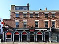
Grade II listed late 18th century brick shop on Slater Street, just off Bold Street. Ground floor in operation as a "party bar".
Media in category "4 Slater Street, Liverpool"
The following 2 files are in this category, out of 2 total.
-
 4 Slater Street 1.jpg 3,070 × 3,264; 6.24 MB
-
 4 Slater Street 2.jpg 4,143 × 3,062; 7.39 MB
