Category:4 - 6 Hale Road, Hale
Jump to navigation
Jump to search
| Object location | | View all coordinates using: OpenStreetMap |
|---|
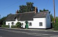
Grade II listed building in Hale, Halton, Cheshire, L24  | |||||
| Upload media | |||||
| Instance of |
| ||||
|---|---|---|---|---|---|
| Location | Hale, Halton, Cheshire, North West England, England | ||||
| Heritage designation |
| ||||
 | |||||
Pair of Grade II listed late 17th century thatched cottages in Hale, Cheshire.
Media in category "4 - 6 Hale Road, Hale"
The following 5 files are in this category, out of 5 total.
-
 4 - 6 Hale Road, Hale 1.jpg 4,998 × 2,884; 7.26 MB
-
 4 - 6 Hale Road, Hale 2.jpg 4,708 × 3,207; 7.89 MB
-
 4-6 Hale Road, Hale.jpg 2,382 × 1,499; 1,015 KB
-
 Hale, Cheshire (12).JPG 4,320 × 3,240; 3.57 MB
-
 Thatched cottage, Hale Village - geograph.org.uk - 40459.jpg 640 × 480; 60 KB


.JPG)
