Category:46 & 48 Olive Lane, Wavertree
Jump to navigation
Jump to search
| Object location | | View all coordinates using: OpenStreetMap |
|---|
architectural structure in Liverpool, Merseyside, England, UK  | |||||
| Upload media | |||||
| Instance of | |||||
|---|---|---|---|---|---|
| Location | Liverpool, Merseyside, North West England, England | ||||
| Heritage designation |
| ||||
 | |||||
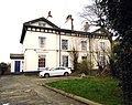
No 46 (Rooklands) and No 48 (Westfield) Olive Lane, Wavertree are a pair of 1850s Grade II listed houses.
Media in category "46 & 48 Olive Lane, Wavertree"
The following 3 files are in this category, out of 3 total.
-
 46 & 48 Olive Lane, Wavertree.jpg 4,591 × 3,684; 9.35 MB
-
 46 Olive Lane, Wavertree.jpg 4,133 × 3,265; 7.82 MB
-
 48 Olive Lane, Wavertree.jpg 4,256 × 3,384; 7.15 MB

