Category:43 - 47 Bold Street, Liverpool
Jump to navigation
Jump to search
| Object location | | View all coordinates using: OpenStreetMap |
|---|
building in Liverpool, Merseyside, England, UK  | |||||
| Upload media | |||||
| Instance of | |||||
|---|---|---|---|---|---|
| Location | Liverpool, Merseyside, North West England, England | ||||
| Heritage designation |
| ||||
 | |||||
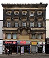
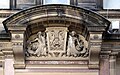
Built for the Liverpool Union Bank, 1885, architect G E Grayson. Taken over by Lloyds in 1900 and closed in 1927 when they opened a branch opposite, on Slater Street.
Media in category "43 - 47 Bold Street, Liverpool"
The following 4 files are in this category, out of 4 total.
-
 43 - 47 Bold Street 1.jpg 3,312 × 3,492; 6.44 MB
-
 43 - 47 Bold Street, Liverpool 201810.jpg 3,162 × 3,720; 4.85 MB
-
 43 - 47 Bold Street, Liverpool.jpg 3,533 × 3,125; 4.99 MB
-
 Detail, 43 - 47 Bold Street.jpg 5,171 × 3,245; 8.79 MB


