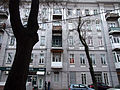
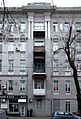
Category:42/16 Kovalska Street, Odesa
Jump to navigation
Jump to search

| Object location | | View all coordinates using: OpenStreetMap |
|---|
building in Ukraine  | |||||
| Upload media | |||||
| Instance of | |||||
|---|---|---|---|---|---|
| Location |
| ||||
| Located on street |
| ||||
 | |||||
Subcategories
This category has only the following subcategory.
Media in category "42/16 Kovalska Street, Odesa"
The following 15 files are in this category, out of 15 total.
-
 2016 Одеса (160) Ковальська вул., 42.jpg 3,642 × 2,423; 10.15 MB
-
 51-101-0515 Odesa Kovalska SAM 7501.jpg 3,056 × 4,592; 3.13 MB
-
 Kovalska 42 snowstorm.jpg 2,411 × 3,215; 1.45 MB
-
 Odesa Kovalska 42 1.jpg 2,520 × 1,890; 2.07 MB
-
 Odesa Kovalska 42 2.jpg 2,530 × 2,084; 2.42 MB
-
 Odesa Kovalska 42 3.JPG 2,755 × 2,066; 2.15 MB
-
 Odesa Kovalska 42 4.jpg 1,602 × 2,362; 1.69 MB
-
 Odesa Kovalska 42 5.jpg 2,686 × 2,014; 2.42 MB
-
 Odesa Kovalska 42 6.jpg 2,443 × 1,832; 2.04 MB
-
 Odesa Kovalska 42 7.jpg 1,548 × 2,780; 3.04 MB
-
 Odesa Kovalska 42 SAM 7500 51-101-0515.JPG 3,056 × 4,592; 2.4 MB
-
 Odesa Kovalska SAM 7502 51-101-0515.JPG 3,056 × 4,592; 2.21 MB
-

-
 Будинок Рудь.jpg 2,848 × 4,288; 4.05 MB
-
 Одеські памятки Ковальська вул., 42.jpg 3,872 × 2,576; 5.16 MB
_%D0%9A%D0%BE%D0%B2%D0%B0%D0%BB%D1%8C%D1%81%D1%8C%D0%BA%D0%B0_%D0%B2%D1%83%D0%BB.,_42.jpg)


