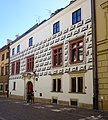
Category:3 Kanonicza Street in Kraków
Jump to navigation
Jump to search
| Object location | | View all coordinates using: OpenStreetMap |
|---|
historic kaminica (tenement) in Kraków, Poland  | |||||
| Upload media | |||||
| Instance of | |||||
|---|---|---|---|---|---|
| Location | Kraków, Lesser Poland Voivodeship, Poland | ||||
| Street address |
| ||||
| Heritage designation |
| ||||
| Inception |
| ||||
 | |||||
| Address |
|
Media in category "3 Kanonicza Street in Kraków"
The following 15 files are in this category, out of 15 total.
-
 BursaGrochowa-UlicaKanonicza3-POL, Kraków.jpg 3,440 × 3,832; 3.36 MB
-
 Kanonicza 3 (2) tr.JPG 1,682 × 2,523; 2.01 MB
-
 Kanonicza 3 tr.JPG 1,737 × 2,856; 2.04 MB
-
 Krakow Kanonicza3 6637.JPG 2,467 × 2,367; 4.51 MB
-
 Krakow Kanonicza3 C41.jpg 3,397 × 3,219; 8.13 MB
-
 Krakow portal Kanonicza 3.jpg 1,200 × 1,600; 1.22 MB
-
 Kraków Kanonicza 1 i 3.JPG 1,600 × 1,200; 699 KB
-
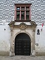 Kraków Kanonicza3portal.JPG 1,200 × 1,600; 598 KB
-
 Kraków, Bursa Grochowa - fotopolska.eu (339753).jpg 833 × 1,250; 249 KB
-
 Kraków, ul. Kanonicza 3; fot. 01.jpg 3,852 × 2,887; 2.44 MB
-
 Kraków, ul. Kanonicza 3; fot. 02.jpg 3,000 × 4,000; 3.26 MB
-
 Kraków, ul. Kanonicza 3; fot. 03.jpg 3,000 × 4,000; 2.77 MB
-
 Kraków, ul. Kanonicza 3; fot. 04.jpg 3,000 × 4,000; 3.15 MB
-
 Portal at 3 Kanonicza Street in Kraków, 2023.jpg 3,024 × 4,032; 2.81 MB
-
 Portal at 3 Kanonicza Street in Kraków, Poland, 2019.jpg 2,844 × 3,792; 3.23 MB
_tr.JPG)


.jpg)


