Category:37 Tadeusza Kościuszki Street in Kraków
Jump to navigation
Jump to search
| Object location | | View all coordinates using: OpenStreetMap |
|---|
 | |||||
| Upload media | |||||
| Instance of | |||||
|---|---|---|---|---|---|
| Location | Kraków, Lesser Poland Voivodeship, Poland | ||||
| Street address |
| ||||
| Heritage designation |
| ||||
| Inception |
| ||||
 | |||||
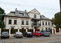
Polski: Dwór Łowczego w Krakowie, dawny dwór folwarczny Norbertanek.
| Address |
|
Media in category "37 Tadeusza Kościuszki Street in Kraków"
The following 4 files are in this category, out of 4 total.
-
 Dwór łowczego od frontu.jpg 1,040 × 743; 399 KB
-
 DwórŁowczego-UlicaKościuszki-POL, Kraków.jpg 4,504 × 2,352; 2.87 MB
-
 נוף רחוב בקרקוב (22).jpg 5,184 × 3,888; 4.45 MB
-
 波蘭奧斯威辛集中營博物館(世界遺產)4.jpg 3,008 × 2,000; 1.13 MB

.jpg)
4.jpg)