Category:37 - 40 Falkner Square
Jump to navigation
Jump to search
| Object location | | View all coordinates using: OpenStreetMap |
|---|
building in Liverpool, Merseyside, England, UK  | |||||
| Upload media | |||||
| Instance of | |||||
|---|---|---|---|---|---|
| Location | Liverpool, Merseyside, North West England, England | ||||
| Heritage designation |
| ||||
 | |||||
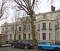
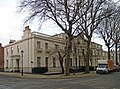
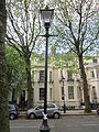
c. 1835 terrace of six houses, four of which face Falkner Square, and including 78/78a Canning Street & 53 Huskisson Street on the returns.
Media in category "37 - 40 Falkner Square"
The following 10 files are in this category, out of 10 total.
-
 37 - 40 Falkner Square 2.jpg 4,527 × 3,596; 7.47 MB
-
 37 - 40 Falkner Square 3.jpg 4,210 × 3,580; 7.58 MB
-
 37 - 40 Falkner Square 4.jpg 4,227 × 3,141; 7.25 MB
-
 37 - 40 Falkner Square 5.jpg 4,771 × 2,808; 6.68 MB
-
 78 Canning Street.jpg 4,584 × 3,344; 6.09 MB
-
 Falkner Square, Liverpool (10).JPG 3,240 × 4,320; 4.92 MB
-
 Falkner Square, Liverpool (7).JPG 4,320 × 3,240; 3.68 MB
-
 Falkner Square, Liverpool (9).JPG 4,320 × 3,240; 4.84 MB
-
 Falkner Square, Liverpool.JPG 2,048 × 1,536; 1.46 MB
-
 House on the corner of Huskisson Street and Sandon Street, Liverpool.JPG 4,608 × 3,456; 3.53 MB


.JPG)
.JPG)
.JPG)

