Category:32 Hope Street, Liverpool
Jump to navigation
Jump to search
| Object location | | View all coordinates using: OpenStreetMap |
|---|
music venue in Liverpool, UK  | |||||
| Upload media | |||||
| Instance of | |||||
|---|---|---|---|---|---|
| Location | Liverpool, Merseyside, North West England, England | ||||
| Located on street |
| ||||
| Inception |
| ||||
| Different from | |||||
 | |||||
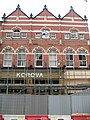
Formerly a livery stable, then The Korova, a music venue, and now refurbished after a 2010 fire as Frederik's, a bar, diner & music venue.
Media in category "32 Hope Street, Liverpool"
The following 2 files are in this category, out of 2 total.
-
 32 Hope Street, Liverpool.jpg 3,444 × 3,200; 5.49 MB
-
 Korova Hope Street April 14 2010 006.jpg 2,304 × 3,072; 1.14 MB
