Category:24 - 30 Berry Street, Liverpool
Jump to navigation
Jump to search
| Object location | | View all coordinates using: OpenStreetMap |
|---|
building in Liverpool, Merseyside, England, UK  | |||||
| Upload media | |||||
| Instance of | |||||
|---|---|---|---|---|---|
| Location | Liverpool, Merseyside, North West England, England | ||||
| Heritage designation |
| ||||
 | |||||
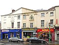
Grade II listed, three shops, formerly part of a residential and commercial complex known as Warmsley's Yard. c.1798-1803.
Media in category "24 - 30 Berry Street, Liverpool"
The following 4 files are in this category, out of 4 total.
-
 24 - 30 Berry Street 1.jpg 4,264 × 3,264; 6.11 MB
-
 24 - 30 Berry Street 2.jpg 4,224 × 3,240; 5.87 MB
-
 85 & 87 Seel Street, Liverpool.jpg 3,058 × 4,524; 7.27 MB
-
 87 Seel Street.jpg 3,493 × 3,697; 6.05 MB


