Category:22 Hallera Street in Starogard Gdański
Jump to navigation
Jump to search
| Object location | | View all coordinates using: OpenStreetMap |
|---|
Polski: Starogard Gdański, ul. gen. Józefa Hallera 22 - kamienica
house in Starogard Gdański, Poland  | |||||
| Upload media | |||||
| Instance of | |||||
|---|---|---|---|---|---|
| Location | Starogard Gdański, Starogard County, Pomeranian Voivodeship, Poland | ||||
| Street address |
| ||||
| Heritage designation |
| ||||
| Inception |
| ||||
 | |||||
Media in category "22 Hallera Street in Starogard Gdański"
The following 5 files are in this category, out of 5 total.
-
 Hallera 22 w Starogardzie Gdańskim.jpg 4,032 × 3,024; 3.81 MB
-
 Wlz1209 ked Kamienica Hallera 22 Starogard Gdański 01.jpg 4,272 × 2,848; 3.97 MB
-
 Wlz1209 ked Kamienica Hallera 22 Starogard Gdański 02.jpg 3,749 × 2,296; 3.79 MB
-
 Wlz1209 ked Kamienica Hallera 22 Starogard Gdański 03 rzeźba.jpg 2,001 × 1,013; 1.26 MB
-
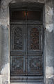 Wlz1209 ked Kamienica Hallera 22 Starogard Gdański 04 drzwi.jpg 2,372 × 3,651; 3.97 MB


