Category:20th-century maps of the Eastern Mediterranean
Jump to navigation
Jump to search
English: This category collects 20th-century maps that show only the Eastern part of the Mediterranean Sea (between Italy and the Levante). This includes (from northwest to east) the Adriatic Sea, the Ionian Sea, the Libyan Sea, the Aegean Sea, the Sea of Marmara, the Levantine Sea and the Cilician Sea.
Incomplete maps (like cut-off double pages) should be categorized according to the full content of the original map, unless it is a deliberate crop.
Incomplete maps (like cut-off double pages) should be categorized according to the full content of the original map, unless it is a deliberate crop.
Subcategories
This category has only the following subcategory.
A
Media in category "20th-century maps of the Eastern Mediterranean"
The following 19 files are in this category, out of 19 total.
-
 C+B-Paul-MapOfEasternMediterranean.JPG 1,709 × 1,106; 618 KB
-
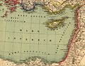
 Heinrich Kiepert. Asia citerior.Aegyptus.Mare.Aegyptium.Libya.jpg 2,585 × 755; 302 KB
-
 Heinrich Kiepert. Asia citerior.Mare.Internum.jpg 3,608 × 2,816; 1.69 MB
-
 Heinrich Kiepert. Asia citerior.Mare.Lycium.jpg 2,556 × 1,019; 512 KB
-
 Heinrich Kiepert. Imperia Persarum et Macedonum. 1903 (H).jpg 2,115 × 2,557; 3.94 MB
-
 South-eastern Europe c. 1180.jpg 2,046 × 1,612; 1.87 MB
-

-

-
 Mittelmeer ost.jpg 4,564 × 3,948; 6.08 MB
-
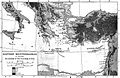
 Review of reviews and world's work (1890) (14596763157).jpg 2,014 × 1,324; 354 KB
-
 Bacon's war map of Mesopotamia (5008076).jpg 5,000 × 3,334; 2.56 MB
-
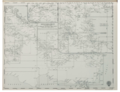 Catalogue of Admiralty Charts 1914 Index Sheet 06 the Mediterranean, Eastern Part.png 3,720 × 2,866; 7.42 MB
-
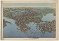 1916 bird's eye view map - Dall'Adriatico al Mar Nero.jpg 11,886 × 8,284; 13.98 MB
-
 Mediterranean littoral 1914-1918.jpg 997 × 603; 243 KB
-
 Biblia Wujka - mapa str. 1159.jpg 3,134 × 1,955; 1.61 MB
-
 1940 German military map - Übersichtskarte Athen-Alexandrien.jpg 24,741 × 32,540; 98.28 MB
-
 1940 German military map - Übersichtskarte Konya-Kairo.jpg 24,890 × 32,570; 130.85 MB
-
 Lands of the Bible, 1956.jpg 4,852 × 3,404; 8.38 MB
-
 Admiralty Chart Catalogue 1967 Page 036 Index F.jpg 8,582 × 6,860; 9.85 MB


.jpg)

_(14781479144).jpg)
_(14783489772).jpg)

_(14596763157).jpg)
.jpg)


