Category:20th-century maps of Pas-de-Calais
Jump to navigation
Jump to search
Media in category "20th-century maps of Pas-de-Calais"
The following 3 files are in this category, out of 3 total.
-
 Carte ancienne du Nord-Pas-de-Calais.jpg 10,000 × 5,800; 21.12 MB
-
 Tracé de l'ancienne ligne Berck-Plage - Paris-Plage.jpg 1,068 × 2,048; 1.01 MB
-
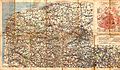
 1943 Pas de Calais map from MI6 archive.gif 383 × 367; 120 KB


