Category:20th-century maps of Morbihan
Jump to navigation
Jump to search
Subcategories
This category has only the following subcategory.
L
- 20th-century maps of Lorient (2 F)
Media in category "20th-century maps of Morbihan"
The following 7 files are in this category, out of 7 total.
-
 Carte routière presqu'île de Rhuys.jpg 3,120 × 3,256; 9.14 MB
-
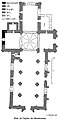 Plan de l'église de Merlevenez.jpg 269 × 536; 85 KB
-
 Plan des haras de Langonnet.jpg 577 × 552; 203 KB
-
 Admiralty Chart No 304 Lorient Harbour, Published 1942.jpg 11,083 × 16,263; 54.39 MB
-
 Admiralty Chart No 2359 Entree de Morbihan, Published 1944.jpg 11,103 × 16,227; 63.93 MB
-
 Admiralty Chart No 2352 Presqu'ile de Quiberon to Anse de Benodet, Published 1962.jpg 18,776 × 11,268; 44.34 MB
-
 Toponymie de Quiberon..png 9,998 × 6,720; 50.96 MB


