Category:2024 aerial photographs of the United States
Jump to navigation
Jump to search
Deutsch: Luftbildfotografien aus die Vereinigte Staaten von Amerika von 2024.
English: 2024 aerial photographs of the United States.
Svenska: Flygfotografier från USA 2024.
Subcategories
This category has only the following subcategory.
Media in category "2024 aerial photographs of the United States"
The following 93 files are in this category, out of 93 total.
-
 09-FEB-2024 - FI688 MCO-KEF (TF-ICR - B737 MAX 8) (01).jpg 3,944 × 2,958; 4.1 MB
-
 Allegheny County Airport aerial shot.jpg 3,696 × 2,773; 2.15 MB
-
 Beaver County Airport aerial shot.jpg 2,782 × 1,262; 937 KB
-
 Butler Farm Show airport during Butler Farm Show, 2024.jpg 3,874 × 2,218; 2.49 MB
-
 Butler Farm Show Airport Trump Rally 2024 05 (cropped).jpg 768 × 408; 155 KB
-
 Carroll County - Tolson Airport aerial shot.jpg 3,875 × 2,906; 2.16 MB
-
 Cleveland Hopkins International Airport aerial shot May 2024.jpg 1,404 × 1,092; 227 KB
-
 Conemaugh Generating Station 01.jpg 4,032 × 3,024; 3.7 MB
-
 Conemaugh Generating Station 02.jpg 4,032 × 3,024; 4.18 MB
-
 Conemaugh Generating Station 03.jpg 4,032 × 3,024; 4.59 MB
-
 Donald R. Lobaugh Bridge - aerial shot 2024.jpg 4,032 × 3,024; 2.83 MB
-
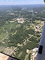
 Dubois aerial shot 2024.jpg 3,442 × 1,937; 1.69 MB
-
 Dubois Regional Airport (KDUJ), 20240601 01.jpg 4,032 × 3,024; 2.1 MB
-
 Dubois Regional Airport (KDUJ), 20240601 02.jpg 4,032 × 3,024; 2.21 MB
-
 Dubois Regional Airport (KDUJ), 20240601 03.jpg 4,032 × 3,024; 2.73 MB
-
 Dubois Regional Airport (KDUJ), 20240601 04.jpg 4,032 × 3,024; 2.69 MB
-
 Dubois Regional Airport (KDUJ), 20240601 05.jpg 4,032 × 3,024; 2.76 MB
-
 Dubois Regional Airport (KDUJ), 20240601 06.jpg 4,032 × 3,024; 3.43 MB
-
 Dubois Regional Airport (KDUJ), 20240601 07.jpg 4,032 × 3,024; 3.44 MB
-
 Dubois Regional Airport (KDUJ), 20240601 08.jpg 4,032 × 3,024; 3.09 MB
-
 Dubois Regional Airport (KDUJ), 20240601 09.jpg 4,032 × 3,024; 2.85 MB
-
 Dubois Regional Airport (KDUJ), 20240601 10.jpg 4,032 × 3,024; 2.96 MB
-
 Dubois Regional Airport (KDUJ), 20240601 11.jpg 4,032 × 3,024; 2.23 MB
-
 Dubois Regional Airport (KDUJ), 20240601 12.jpg 4,032 × 3,024; 2.14 MB
-
 Fourth of July 2024, Downtown Pittsburgh firework aerial shots 01.jpg 4,032 × 3,024; 2.75 MB
-
 Fourth of July 2024, Downtown Pittsburgh firework aerial shots 02.jpg 4,032 × 3,024; 2.29 MB
-
 Fourth of July 2024, Downtown Pittsburgh firework aerial shots 03.jpg 4,032 × 3,024; 3.12 MB
-
 Fourth of July 2024, Downtown Pittsburgh firework aerial shots 04.jpg 4,032 × 3,024; 2.66 MB
-
 Fourth of July 2024, Downtown Pittsburgh firework aerial shots 05.jpg 4,032 × 3,024; 2.47 MB
-
 Fourth of July 2024, Downtown Pittsburgh firework aerial shots 06.jpg 4,032 × 3,024; 2.88 MB
-
 Fourth of July 2024, Downtown Pittsburgh firework aerial shots 07.jpg 4,032 × 3,024; 2.58 MB
-
 Fourth of July 2024, Downtown Pittsburgh firework aerial shots 08.jpg 4,032 × 3,024; 2.45 MB
-
 Fourth of July 2024, Downtown Pittsburgh firework aerial shots 09.jpg 4,032 × 3,024; 2.48 MB
-
 Fourth of July 2024, Downtown Pittsburgh firework aerial shots 10.jpg 4,032 × 3,024; 2.48 MB
-
 Fourth of July 2024, Downtown Pittsburgh firework aerial shots 11.jpg 4,032 × 3,024; 2.43 MB
-
 Fourth of July 2024, Downtown Pittsburgh firework aerial shots 12.jpg 4,032 × 3,024; 2.87 MB
-
 Grove City aerial shot 2024-06-15 1.jpg 1,067 × 1,000; 321 KB
-
 Grove City aerial shot 2024-06-15 2.jpg 4,032 × 3,024; 5.4 MB
-
 Grove City aerial shot 2024-06-15 3.jpg 4,032 × 3,024; 4.64 MB
-
 Grove City aerial shot 2024-06-15 4.jpg 4,032 × 3,024; 5.35 MB
-
 Grove City aerial shot 2024-06-15 5.jpg 4,032 × 3,024; 4.65 MB
-
 Grove City aerial shot 2024-06-15 6.jpg 3,495 × 2,909; 3.68 MB
-
 Grove City Airport aerial shot.jpg 3,152 × 1,927; 1.06 MB
-
 Highland Park, Pittsburgh, Pennsylvania, United States Aerial Shot.jpg 3,076 × 2,389; 1.79 MB
-
 Mayo Field in Rochester, Minnesota 01.jpg 6,357 × 3,028; 14.74 MB
-
 Mayo Field in Rochester, Minnesota 02.jpg 4,110 × 5,172; 14.98 MB
-
 Mayo High School - Rochester 01.jpg 4,000 × 1,621; 5.28 MB
-
 Mayo High School - Rochester 02.jpg 4,000 × 2,520; 7.55 MB
-
 Mayo High School - Rochester 03.jpg 4,000 × 1,619; 4.64 MB
-
 Mayo St. Marys.jpg 4,137 × 2,417; 8.06 MB
-
 McVille Airport aerial shot 01.jpg 1,928 × 1,439; 518 KB
-
 Olmsted Medical Center Rochester - 2024.jpg 4,000 × 2,252; 7.01 MB
-
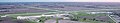
 Pittsburgh Northeast Airport aerial shot.jpg 3,025 × 1,851; 758 KB
-
 Pittsburgh-Butler Regional Airport aerial shot.jpg 3,312 × 2,158; 3.8 MB
-
 Point Lookout, Lido Beach and Long Beach, New York from the air, June 2024.jpg 2,960 × 3,947; 2.41 MB
-
 Port Meadville Airport 2024-06-15 09.jpg 3,271 × 1,704; 895 KB
-
 Port Meadville Airport 2024-06-15 10.jpg 1,746 × 1,135; 421 KB
-
 Port Meadville Airport 2024-06-15 11.jpg 3,046 × 1,747; 1.24 MB
-
 Port Meadville Airport 2024-06-15 12.jpg 4,032 × 3,024; 3.2 MB
-
 Port Meadville Airport 2024-06-15 13.jpg 4,032 × 3,024; 1.89 MB
-
 Port Meadville Airport 2024-06-15 14.jpg 4,032 × 3,024; 3.66 MB
-
 Port Meadville Airport 2024-06-15 15.jpg 4,032 × 3,024; 3.4 MB
-
 Port Meadville Airport 2024-06-15 16.jpg 1,697 × 1,279; 368 KB
-
 Port Meadville Airport 2024-06-15 17.jpg 4,032 × 3,024; 3.16 MB
-
 Port Meadville Airport 2024-06-15 18.jpg 3,147 × 2,305; 1.44 MB
-
 Reynoldsville aerial shot 2024.jpg 1,796 × 1,067; 438 KB
-
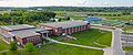 Rochester Community and Technical College 01.jpg 3,922 × 1,629; 4.8 MB
-
 Rochester Community and Technical College 02.jpg 5,392 × 1,685; 6.51 MB
-
 Rochester CTECH 01.jpg 4,000 × 3,000; 11.25 MB
-
 Rochester CTECH 02.jpg 4,000 × 3,000; 7.7 MB
-
 Rochester International Airport 01.jpg 4,575 × 868; 2.17 MB
-
 Rochester International Airport 02.jpg 6,672 × 1,204; 4.43 MB
-
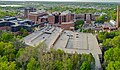
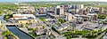
 Rochester Minnesota Skyline 01.jpg 7,108 × 3,239; 13.14 MB
-
 Rochester Minnesota Skyline 02.jpg 4,505 × 1,785; 6.49 MB
-
 Rochester Minnesota Skyline 03.jpg 5,377 × 2,095; 8.47 MB
-
 Rochester Minnesota Skyline 04.jpg 5,223 × 1,906; 7.6 MB
-
 Rochester Minnesota Skyline 05.jpg 6,368 × 3,058; 12.72 MB
-
 Rochester Minnesota Skyline 06.jpg 5,537 × 2,814; 10.05 MB
-
 Salem Airpark aerial shot.jpg 3,021 × 2,257; 944 KB
-
 Sandy Lake, Pennsylvania aerial 2024-06-15 1.jpg 3,024 × 4,032; 3.45 MB
-
 Sandy Lake, Pennsylvania aerial 2024-06-15 2.jpg 3,024 × 4,032; 3.71 MB
-
 Sandy Lake, Pennsylvania aerial 2024-06-15 3.jpg 2,538 × 1,619; 1.42 MB
-
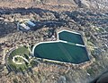
 Silver Lake in Rochester.jpg 4,658 × 3,000; 10.39 MB
-
 Slippery Rock University aerial.jpg 3,433 × 2,309; 1.75 MB
-
 Teterboro Airport aerial shot.jpg 4,028 × 2,439; 3.47 MB
-
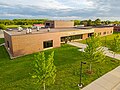
 University of Pittsburgh at Johnstown aerial photograph 01.jpg 4,032 × 3,024; 4.19 MB
-
 University of Pittsburgh at Johnstown aerial photograph 02.jpg 4,032 × 3,024; 2.47 MB
-
 University of Pittsburgh at Johnstown aerial photograph 03.jpg 4,032 × 3,024; 3.17 MB
-
 University of Pittsburgh at Johnstown aerial photograph 04.jpg 4,032 × 3,024; 3.05 MB
-
 University of Pittsburgh at Johnstown aerial photograph 05.jpg 3,567 × 2,686; 2.7 MB
-
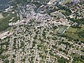
 Vandergrift, PA aerial shot 02.jpg 2,256 × 1,522; 1.11 MB
-
 Vandergrift, PA aerial shot 03.jpg 4,032 × 3,024; 3.96 MB
-
 Zelienople Municipal Airport aerial shot.jpg 3,962 × 2,624; 1.47 MB
_(01).jpg)


.jpg)


,_20240601_01.jpg)
,_20240601_02.jpg)
,_20240601_03.jpg)
,_20240601_04.jpg)
,_20240601_05.jpg)
,_20240601_06.jpg)
,_20240601_07.jpg)
,_20240601_08.jpg)
,_20240601_09.jpg)
,_20240601_10.jpg)
,_20240601_11.jpg)
,_20240601_12.jpg)


