Category:2018 maps of Virginia
Jump to navigation
Jump to search
States of the United States: California · Colorado · Iowa · Louisiana · New York · Pennsylvania · Utah · Virginia – Washington, D.C.
| ← 2010 2013 2015 2016 2018 |
Media in category "2018 maps of Virginia"
The following 2 files are in this category, out of 2 total.
-
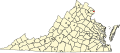 Map of Virginia highlighting Alexandria and Arlington.svg 2,495 × 1,082; 159 KB
-
 Numbered Map of Virginia Counties and Independent Cities.svg 1,260 × 585; 264 KB

