Category:2011 in water transport in the United Kingdom
Jump to navigation
Jump to search
Subcategories
This category has the following 3 subcategories, out of 3 total.
L
R
W
Media in category "2011 in water transport in the United Kingdom"
The following 88 files are in this category, out of 88 total.
-
 Mount Batten from the Barbican.jpg 1,024 × 682; 308 KB
-
 Burghfield MMB 01 Kennet & Avon Canal.jpg 3,742 × 2,494; 5.12 MB
-
 Burghfield MMB 02 Kennet & Avon Canal.jpg 3,872 × 2,576; 3.43 MB
-
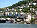 Kingswear ferries and station.jpg 1,024 × 768; 346 KB
-
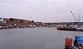 Whitby MMB 23 Harbour.jpg 3,888 × 2,289; 2.87 MB
-
 Whitby MMB 24 Harbour.jpg 3,717 × 2,388; 2.85 MB
-
 Whitby MMB 25 Harbour.jpg 3,819 × 2,466; 3.17 MB
-
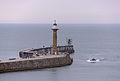 Whitby MMB 31 Harbour.jpg 3,705 × 2,499; 2.49 MB
-
 Scarborough MMB 07.jpg 3,560 × 1,956; 1.75 MB
-
 Scarborough MMB 14 Lifeboat station.jpg 2,462 × 3,540; 2.5 MB
-
 Scarborough MMB 15 Lifeboat station.jpg 3,825 × 2,545; 1.69 MB
-
 Scarborough MMB 17 Harbour.jpg 3,907 × 2,295; 2.55 MB
-
 Scarborough MMB 21.jpg 3,294 × 1,965; 1.99 MB
-
 Scarborough MMB 22 Harbour.jpg 3,837 × 2,551; 2.95 MB
-
 Scarborough MMB 24 Harbour.jpg 3,729 × 2,289; 3.09 MB
-
 Scarborough MMB 25 Harbour.jpg 3,693 × 2,328; 2.92 MB
-
 Scarborough MMB 26 Fish Market.jpg 3,846 × 2,551; 2.72 MB
-
 Scarborough MMB 27 Fish Market.jpg 3,834 × 2,531; 2.06 MB
-
 Scarborough MMB 28.jpg 2,519 × 3,795; 3.1 MB
-
 Scarborough MMB 33.jpg 3,279 × 2,385; 3.11 MB
-
 Redcar MMB 07.jpg 15,629 × 2,493; 7.81 MB
-
 Redcar MMB 17.jpg 3,771 × 2,262; 2.04 MB
-
 Redcar MMB 18.jpg 3,582 × 2,163; 2.36 MB
-
 Solent Class ON1021 Douglas Currie at Poole.jpg 1,023 × 768; 312 KB
-
 Irlam MMB 01 Manchester Ship Canal.jpg 3,852 × 1,953; 1.8 MB
-
 Irlam MMB 03 Manchester Ship Canal.jpg 3,711 × 1,983; 1.88 MB
-
 Birmingham MMB 13 Cross-City Line 43366.jpg 3,795 × 2,412; 2.67 MB
-
 Banbury MMB 01 Oxford Canal.jpg 3,645 × 2,367; 2.44 MB
-
 Brighton Lifeboat Station in 2011.jpg 1,024 × 512; 134 KB
-
 A small boatyard on Oare Creek - geograph.org.uk - 2251497.jpg 640 × 458; 67 KB
-
 Aldeburgh (23397052765).jpg 2,592 × 1,944; 1.58 MB
-
 Barges at Faversham Creek - geograph.org.uk - 2597287.jpg 640 × 480; 147 KB
-
 Barges on Faversham Creek - geograph.org.uk - 2597304.jpg 640 × 480; 120 KB
-
 Boats off Newquay harbour (5960).jpg 4,288 × 2,848; 6.45 MB
-
 Bognor Beach - geograph.org.uk - 2390444.jpg 1,280 × 856; 253 KB
-
 Braunston Sign near London.jpg 384 × 512; 133 KB
-
 Bridge 33 Lapworth (5710008061).jpg 4,328 × 2,644; 7.97 MB
-
 Bridge 98a, Lancaster Canal 6943.JPG 3,488 × 2,616; 2.14 MB
-
 Bridgewater Canal with the Waterloo Bridge in the background - panoramio.jpg 4,288 × 2,864; 7.23 MB
-
 Brighton lifeboat house and B-753.jpg 1,024 × 768; 208 KB
-
 British Isles rural and coastal Norfolk (6479038501).jpg 4,256 × 2,832; 638 KB
-
 Bucklers Hard - geograph.org.uk - 2595766.jpg 2,880 × 1,920; 1.86 MB
-

-

-

-
 Bucklers Hard, steamer at the pier - geograph.org.uk - 2494428.jpg 640 × 480; 59 KB
-
 Bucklers Hard, towards the marina - geograph.org.uk - 2494411.jpg 480 × 640; 44 KB
-
 Cows by Faversham Creek - geograph.org.uk - 2592235.jpg 640 × 480; 143 KB
-

-
 Dover - panoramio (28).jpg 4,000 × 3,000; 3.34 MB
-
 Dover - panoramio (34).jpg 4,000 × 3,000; 3.36 MB
-
 DOVER - panoramio.jpg 4,592 × 3,056; 3.99 MB
-
 Dover Marina - geograph.org.uk - 2711440.jpg 640 × 430; 59 KB
-
 Dover, Western Docks - geograph.org.uk - 2559205.jpg 3,648 × 2,736; 1.14 MB
-
 Faversham Creek - geograph.org.uk - 2597312.jpg 640 × 480; 121 KB
-
 Faversham Creek at low tide - geograph.org.uk - 2478677.jpg 640 × 510; 59 KB
-
 Faversham Creek at low tide - geograph.org.uk - 2478701.jpg 640 × 480; 59 KB
-
 Faversham Quay2.jpg 4,498 × 3,234; 5.87 MB
-
 Fazeley - panoramio (1).jpg 4,000 × 3,000; 3.52 MB
-
 Fazeley - panoramio (10).jpg 4,000 × 3,000; 3.63 MB
-
 Fazeley - panoramio (15).jpg 4,000 × 3,000; 3.73 MB
-
 Fazeley - panoramio (16).jpg 4,000 × 3,000; 3.52 MB
-
 Fazeley - panoramio (2).jpg 4,000 × 3,000; 3.88 MB
-
 Fazeley - panoramio (3).jpg 4,000 × 3,000; 4.3 MB
-
 Fazeley - panoramio (4).jpg 4,000 × 3,000; 3.15 MB
-
 Fazeley - panoramio (5).jpg 4,000 × 3,000; 2.87 MB
-
 Fazeley - panoramio (6).jpg 3,362 × 2,465; 2.91 MB
-
 Fazeley - panoramio (7).jpg 4,000 × 3,000; 3.8 MB
-
 Fazeley - panoramio (8).jpg 4,000 × 3,000; 3.6 MB
-
 Fazeley - panoramio.jpg 4,000 × 3,000; 3.53 MB
-
 Ferries in the Port of Dover- Дувр. Паромы. - panoramio.jpg 3,648 × 2,736; 2.6 MB
-
 Footbridge to Teddington Lock over the Thames - panoramio.jpg 4,592 × 3,056; 12.39 MB
-
 Gloucester Docks. - panoramio (1).jpg 1,952 × 2,592; 1.25 MB
-
 Leicester-Grand Union Canal - geograph.org.uk - 2699864.jpg 640 × 480; 92 KB
-
 Midland Railway Crane, Gloucester Docks. - panoramio.jpg 1,952 × 2,592; 1.01 MB
-
 Mountsorrel lock pano.jpg 4,514 × 1,555; 3.77 MB
-
 Port of Dover. - panoramio.jpg 2,261 × 1,696; 1.78 MB
-
 Porthmadog Harbour at Dusk - geograph.org.uk - 2392447.jpg 1,024 × 683; 136 KB
-
 Rusty Submarine at Rochester.jpg 4,288 × 2,848; 5.55 MB
-
 Sailing barge at Faversham Creek - geograph.org.uk - 2597266.jpg 640 × 480; 112 KB
-
 Sailing barge at Faversham Creek - geograph.org.uk - 2597267.jpg 640 × 480; 133 KB
-
 Sand Dredger, Gloucester Docks. - panoramio.jpg 2,592 × 1,952; 989 KB
-
 Sennen Cove lifeboat (7084).jpg 4,288 × 2,848; 3 MB
-
 Standard Quay - geograph.org.uk - 2597307.jpg 640 × 480; 121 KB
-
 Swan and Cygnets Bridgewater Canal Runcorn - panoramio.jpg 4,288 × 2,864; 5.37 MB
-
 The Port of Dover - geograph.org.uk - 2737129.jpg 640 × 480; 80 KB
-
 Upnor Castle from St. Mary's Island.JPG 780 × 551; 165 KB
-
 View over Felixstowe Port - panoramio.jpg 3,968 × 2,976; 2.71 MB


.jpg)


.jpg)


.jpg)


.jpg)


.jpg)
.jpg)


.jpg)
.jpg)
.jpg)
.jpg)
.jpg)
.jpg)
.jpg)
.jpg)
.jpg)
.jpg)
.jpg)


.jpg)


.jpg)


