Category:2008 aerial photographs of the United States
Jump to navigation
Jump to search
English: 2008 aerial photographs of the United States
Svenska: Flygfotografier från USA 2008
Deutsch: Luftbildfotografien aus die Vereinigte Staaten von Amerika von 2008
Media in category "2008 aerial photographs of the United States"
The following 200 files are in this category, out of 223 total.
(previous page) (next page)-
 2008 11 21 ams-waw-ord-bos 119 (3059719726).jpg 3,504 × 2,336; 2.9 MB
-
 2008 11 21 ams-waw-ord-bos 120 (3059720100).jpg 3,504 × 2,336; 2.95 MB
-
 2008 11 21 ams-waw-ord-bos 121 (3059720360).jpg 3,504 × 2,336; 2.95 MB
-
 2008 11 21 ams-waw-ord-bos 122 (3059720618).jpg 3,504 × 2,336; 2.87 MB
-
 2008 11 21 ams-waw-ord-bos 123 (3059720956).jpg 3,504 × 2,336; 2.86 MB
-
 2008 SpaceX's Rocket Development facility, McGregor, TX.jpg 3,000 × 2,000; 1.48 MB
-
 2008-0914-CapitolReef-WaterpocketFold1.jpg 3,412 × 1,976; 5.41 MB
-
 402 through Sarnia.png 1,979 × 1,085; 3.98 MB
-
-
 Aerial view of Nationals Park (cropped).jpg 3,972 × 2,271; 4.36 MB
-
 Aerial view of Nationals Park (cropped2).jpg 4,114 × 2,932; 5.99 MB
-
 Aerial view of Nationals Park.jpg 4,468 × 3,304; 6.77 MB
-
 Aluminum smelter - near Bellingham.jpg 2,309 × 1,996; 1.48 MB
-
 Anacortes - 2707382645.jpg 3,264 × 2,448; 3.43 MB
-
 Anacortes vicinity - 2707391995.jpg 3,264 × 2,448; 2.8 MB
-
 Anacortes vicinity.jpg 3,264 × 2,448; 3.21 MB
-
 Anacortes, Washington.jpg 3,264 × 2,448; 3.5 MB
-
 Anvil Cloud near Witchita Falls, Texas (2396666396).jpg 3,072 × 2,304; 1.06 MB
-
 Anvil Cloud near Witchita Falls, Texas (2396666860).jpg 3,072 × 2,304; 1.1 MB
-
 Approaching SeaTac Airport - heading East - 2707459331.jpg 3,264 × 2,448; 3.61 MB
-
 Approaching SeaTac Airport - heading East - 2707460583.jpg 3,264 × 2,448; 2.83 MB
-
 Approaching SeaTac Airport - heading East - 2707462181.jpg 3,264 × 2,448; 3.22 MB
-
 Arriving New York City (2800027265).jpg 2,272 × 1,704; 459 KB
-
 Auburn Municipal airport.jpg 3,264 × 2,448; 2.61 MB
-
 Bainbridge Island, South Beach.jpg 3,264 × 2,448; 2.89 MB
-
 Bellingham, Mount Baker.jpg 3,264 × 2,448; 2.34 MB
-
 Bend in Red River near Elmer, Oklahoma (2395822221).jpg 3,072 × 2,304; 1.23 MB
-
 Bend in Red River near Elmer, Oklahoma (2395822661).jpg 3,072 × 2,304; 1.2 MB
-
 Bend in Red River near Elmer, Oklahoma (2395823621).jpg 3,072 × 2,304; 1.19 MB
-
 Bend in Red River near Elmer, Oklahoma (2395823991).jpg 3,072 × 2,304; 1.24 MB
-
 Bend in Red River near Elmer, Oklahoma (2395824451).jpg 3,072 × 2,304; 1.18 MB
-
 Bend in Red River near Elmer, Oklahoma (2396657854).jpg 3,072 × 2,304; 1.21 MB
-
 Bend in Red River, Oklahoma (2395827735).jpg 3,072 × 2,304; 1.14 MB
-
 Bend in Red River, Texas (2396662796).jpg 3,072 × 2,304; 1.11 MB
-
 Bend in Red River, Texas (2396663356).jpg 3,072 × 2,304; 1.17 MB
-
 Bends in Red River , Texas (2396659700).jpg 3,072 × 2,304; 1.19 MB
-
 Bends in Red River west of Frederick, Oklahoma (2396661332).jpg 3,072 × 2,304; 1.1 MB
-
 Blakely Island airstrip - 2708193322.jpg 3,079 × 2,448; 2.15 MB
-
 Blakely Island airstrip.jpg 3,264 × 2,014; 2.79 MB
-
 Blizzard Beach Aerial photo (7426584544).jpg 2,082 × 1,233; 715 KB
-
 Bluff UT - aerial with San Juan River and Comb Ridge.jpg 3,504 × 2,336; 9.08 MB
-

-
 Cape Ann Massachusetts Aerial.jpg 3,495 × 1,732; 3.63 MB
-
 CedarBogLake-EastBethel-MN.jpg 2,916 × 1,965; 3.04 MB
-
 Centennial Middle School, north of Snohomish, Washington.jpg 3,264 × 2,448; 3.68 MB
-
 Chicago (2871480648).jpg 1,200 × 800; 218 KB
-
 Chicago as seen from a commercial flight 23.JPG 1,600 × 1,200; 933 KB
-
 Circle Irrigation east of Hartley, Texas (2395806363).jpg 3,072 × 2,304; 1.1 MB
-
 Circle Irrigation east of Hartley, Texas (2395806747).jpg 3,072 × 2,304; 1.11 MB
-
 Clouds over Red River, Texas (2395829853).jpg 3,072 × 2,304; 1.13 MB
-
 Clouds over Red River, Texas (2395830415).jpg 3,072 × 2,304; 1.12 MB
-
 Clouds over Red River, Texas (2395830795).jpg 3,072 × 2,304; 1.11 MB
-
 Clouds over Red River, Texas (2395831207).jpg 3,072 × 2,304; 1.1 MB
-
 Coupeville and Penn Cove, Whidbey Island - 2707429941.jpg 3,264 × 2,448; 3.47 MB
-
 Coupeville and Penn Cove, Whidbey Island.jpg 3,264 × 2,448; 3.26 MB
-
 Cranston, Rhode Island.jpg 3,820 × 2,745; 2.2 MB
-
 Crossing SeaTac Airport - heading East - 2708282396.jpg 3,264 × 2,448; 3.27 MB
-
 Crossing SeaTac Airport - heading East - 2708283976.jpg 3,264 × 2,448; 3.49 MB
-
 Crossing SeaTac Airport - heading East - 2708284960.jpg 3,264 × 2,448; 2.31 MB
-
 Crossing SeaTac Airport - heading East.jpg 3,264 × 2,448; 3.23 MB
-
 Cypress And Guemes Island.jpg 3,264 × 2,448; 2.8 MB
-
 Deception Pass Bridge, Washington.jpg 3,264 × 2,448; 3.08 MB
-
 Deer Harbor, Orcas Island - 2708186118.jpg 3,264 × 2,448; 3.82 MB
-
 Dike South of Ferndale.jpg 3,264 × 2,448; 2.62 MB
-
 Disney's All-Star Movies aerial photo (7426582258).jpg 2,066 × 1,251; 686 KB
-
 Disney's All-Star Sports aerial photo (7426583484).jpg 2,192 × 1,469; 820 KB
-
 Disney's Hollywood Studios aerial photo (7426555140).jpg 2,444 × 1,020; 637 KB
-
 Disney's Wide World of Sports (7426504780).jpg 2,001 × 1,721; 696 KB
-

-
 Eagle Harbor, Bainbridge Island.jpg 3,264 × 2,448; 3.37 MB
-
 East of Indianola, Kitsap Peninsula.jpg 3,264 × 2,448; 2.66 MB
-
 East of Panhandle, Texas (2396648564).jpg 3,072 × 2,304; 1.04 MB
-
 East side of Bainbridge Island.jpg 3,264 × 2,448; 3.13 MB
-
 Emerald Downs Racetrack.jpg 3,264 × 2,448; 3.41 MB
-
 Epcot aerial photo (7426554146).jpg 1,609 × 1,130; 468 KB
-
 Fort Casey and Keystone Marine Sanctuary, Whidbey Island.jpg 3,264 × 2,448; 2.69 MB
-
 Frederick ?, Oklahoma (2396661828).jpg 3,072 × 2,304; 1.13 MB
-
 Glacier Peak to the east in some haze.jpg 3,264 × 2,448; 2.64 MB
-
 Gould, Oklahoma (2395818837).jpg 3,072 × 2,304; 1.15 MB
-
 Gould, Oklahoma (2395819311).jpg 3,072 × 2,304; 1.14 MB
-
 Grazing on the Stillaguamish River.jpg 3,264 × 2,448; 3.16 MB
-
 Hansville and Driftwood Key.jpg 3,264 × 2,448; 3.42 MB
-
 Henrietta , Texas (2395835661).jpg 3,072 × 2,304; 1.07 MB
-
 Henrietta , Texas (2396671348).jpg 3,072 × 2,304; 1.19 MB
-
 Houses, Bainbridge Island.jpg 3,264 × 2,448; 3.09 MB
-
 I-90 Snoqualmie Ridge East of North Bend, Washington.jpg 3,264 × 2,448; 3.73 MB
-
 I072508 049.jpg 3,264 × 2,448; 3.55 MB
-
 I072508 053.jpg 3,264 × 2,448; 3.41 MB
-
 I072508 064.jpg 3,264 × 2,448; 3.18 MB
-
 I072508 065.jpg 2,737 × 2,283; 2.12 MB
-
 I072508 162.jpg 3,264 × 2,448; 2.84 MB
-
 I072508 164.jpg 3,264 × 2,448; 2.42 MB
-
 I072508 166.jpg 3,264 × 2,448; 2.53 MB
-
 I072508 169.jpg 3,264 × 2,448; 2.6 MB
-
 I072508 174.jpg 3,264 × 2,448; 2.94 MB
-
 I072508 180.jpg 3,264 × 2,448; 3.31 MB
-
 I072508 181.jpg 3,264 × 2,448; 3.05 MB
-
 I072508 183.jpg 3,264 × 2,448; 3.08 MB
-
 Islets off of Deer Harbor, Orcas Island.jpg 3,264 × 2,448; 2.76 MB
-
 Kent Space Center - Boeing - 2707473073.jpg 3,264 × 2,448; 3.31 MB
-
 Kent Space Center - Boeing - 2707474841.jpg 3,264 × 2,448; 3.93 MB
-
 Kent Space Center - Boeing - 2707476391.jpg 3,264 × 2,448; 3.57 MB
-
 Kent Space Center - Boeing - 2707478027.jpg 3,264 × 2,448; 3.78 MB
-
 Kent Space Center - Boeing.jpg 3,264 × 2,448; 3.21 MB
-
 Kingston Ferry Terminal - 2708262424.jpg 3,264 × 2,448; 3.3 MB
-
 Kingston Ferry Terminal.jpg 3,264 × 2,448; 2.92 MB
-
 Kluft-photo-Moffett-Federal-Airfield-Oct-2008-Img 1911.jpg 3,072 × 2,048; 2.33 MB
-
 Lagoon View, West coast of Whidbey Island - 2708252942.jpg 3,264 × 2,448; 3.26 MB
-
 Lagoon View, West coast of Whidbey Island.jpg 3,264 × 2,448; 3.15 MB
-
 Lake Stevens, Washington - 2708135256.jpg 3,264 × 2,448; 3.42 MB
-
 Lake Stevens, Washington.jpg 3,264 × 2,448; 3.61 MB
-
 Looking east to Snoqualmie Valley, North Bend and Mount SI.jpg 3,264 × 2,448; 3.33 MB
-
 Looking North to Seattle - 2708272754.jpg 3,264 × 1,950; 2.26 MB
-
 Looking North to Seattle.jpg 3,264 × 2,448; 2.81 MB
-
 Looking northeast to Oak Harbor, Whidbey Island.jpg 3,264 × 2,448; 2.6 MB
-
 Looking Northeast to West Seattle (and Seattle).jpg 3,264 × 2,448; 2.59 MB
-
 Looking to Discovery Park and Magnolia.jpg 3,264 × 1,624; 1.54 MB
-
 Looking west to Port Townsend.jpg 3,098 × 2,166; 2.57 MB
-
 Massacre Bay, West Sound, Orcas Island.jpg 3,264 × 2,448; 2.68 MB
-
 Memphis (Panhandle), Texas (2395816839).jpg 3,072 × 2,304; 1.2 MB
-
 Memphis (Panhandle), Texas (2395817665).jpg 3,072 × 2,304; 1.25 MB
-
 Memphis (Panhandle), Texas (2396651768).jpg 3,072 × 2,304; 1.17 MB
-
 Memphis (Panhandle), Texas (2396652646).jpg 3,072 × 2,304; 1.19 MB
-
 Memphis (Panhandle), Texas (2396653002).jpg 3,072 × 2,304; 1.17 MB
-
 Monroe Correctional Complex, Washington.jpg 3,264 × 2,448; 3.67 MB
-
 Mount Baker and North Twin Sisters.jpg 3,264 × 2,448; 2.44 MB
-
 Mount Baker and Twin Sisters.jpg 3,264 × 1,655; 1.54 MB
-
 Mount Baker, WA.jpg 3,264 × 2,448; 2.25 MB
-
 Mount Constitution, Orcas Island.jpg 3,264 × 2,448; 2.65 MB
-
 Mount Erie, Anacortes, Washington.jpg 3,264 × 2,448; 3.09 MB
-
 Naval Air Station Whidbey Island (NASWI) Ault Field - 2707413159.jpg 3,264 × 2,448; 3.55 MB
-
 Naval Air Station Whidbey Island (NASWI) Ault Field - 2708220144.jpg 3,264 × 2,448; 3.35 MB
-
 Naval Air Station Whidbey Island (NASWI) Ault Field - 2708222618.jpg 3,264 × 2,448; 3.24 MB
-
 Naval Air Station Whidbey Island (NASWI) Ault Field - 2708227412.jpg 3,264 × 2,448; 3.24 MB
-
 Naval Air Station Whidbey Island (NASWI) Ault Field - 2708232268.jpg 3,264 × 2,448; 3.36 MB
-
 Naval Air Station Whidbey Island (NASWI) Ault Field.jpg 3,264 × 2,448; 3.43 MB
-
 Near Ferndale, Washington.jpg 3,264 × 2,448; 2.82 MB
-
 North Bend, Washington and Mount Si.jpg 3,264 × 2,448; 2.94 MB
-
 North of Lake Stevens.jpg 3,264 × 2,448; 4.05 MB
-
 Northeast side of Bainbridge Island.jpg 3,264 × 2,448; 2.66 MB
-
 Oak Harbor, Whidbey Island.jpg 3,264 × 2,448; 3.06 MB
-
 OOCL Container ship, Puget Sound off West coast of Whidbey Island.jpg 3,264 × 2,448; 2.35 MB
-
 Orcas Island - 2708190170.jpg 3,264 × 2,448; 3.05 MB
-
 Orcas Island.jpg 3,264 × 2,448; 3.66 MB
-
 Orlando World Center Marriott aerial photo (7426506832).jpg 2,299 × 1,396; 763 KB
-
 Powerlines - Auburn, Washington.jpg 3,264 × 2,448; 3.17 MB
-
 Prince Georges Plaza, Hyattsville, Maryland (2893471197).jpg 1,280 × 960; 155 KB
-
 Quarry, South of Monroe, Washington.jpg 3,264 × 2,448; 3.18 MB
-
 Red River east of Panhandle, Texas (2395814597).jpg 3,072 × 2,304; 1.1 MB
-
 Red River west of Lakeview, Texas (2395814965).jpg 3,072 × 2,304; 1.11 MB
-
 Red River west of Lakeview, Texas (2395815629).jpg 3,072 × 2,304; 1.2 MB
-
 Red River west of Lakeview, Texas (2395816059).jpg 3,072 × 2,304; 1.2 MB
-
 Red River west of Lakeview, Texas (2396649696).jpg 3,072 × 2,304; 1.12 MB
-
 Red River west of Lakeview, Texas (2396650894).jpg 3,072 × 2,304; 1.23 MB
-
 Red River, Texas (2395829167).jpg 3,072 × 2,304; 1.15 MB
-
 San Francisco Oakland Bay Bridge New east span-cropped.jpg 2,840 × 2,016; 3 MB
-
 San Francisco Oakland Bay Bridge New east span.jpg 2,846 × 2,912; 961 KB
-
 San Juan Islands.jpg 3,264 × 2,448; 2.5 MB
-
 SeaTac, Washington.jpg 3,264 × 2,448; 3.83 MB
-
 Sheppard AFB, Witchita Falls , Texas (2395832559).jpg 3,072 × 2,304; 1.08 MB
-
 Sheppard AFB, Witchita Falls , Texas (2395832971).jpg 3,072 × 2,304; 1.09 MB
-
 Sheppard AFB, Witchita Falls , Texas (2396668096).jpg 3,072 × 2,304; 1.08 MB
-
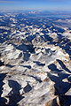 Sierra Nevada aerial.jpg 2,808 × 4,212; 14.53 MB
-
 Skull Island, Massacre Bay, Orcas Island.jpg 3,264 × 2,448; 3.59 MB
-
 Small islets off northeast Orcas Isalnd.jpg 3,264 × 2,448; 2.23 MB
-
 Snoqualmie Falls, 2008.jpg 3,264 × 2,448; 3.15 MB
-
 South of Dalhart, Texas (2396634168).jpg 3,072 × 2,304; 1.07 MB
-
 South of Dalhart, Texas (2396635702).jpg 3,072 × 2,304; 1.06 MB
-
 South of Dalhart, Texas (2396636050).jpg 3,072 × 2,304; 1.07 MB
-
 South of Hartley, Texas (2395804083).jpg 3,072 × 2,304; 1.12 MB
-
 South of Hartley, Texas (2396638106).jpg 3,072 × 2,304; 1.12 MB
-
 South of Lake Meredith and Fritch, Texas (2395809053).jpg 3,072 × 2,304; 1.12 MB
-
 South of Lake Meredith and Fritch, Texas (2395809375).jpg 3,072 × 2,304; 1.12 MB
-
 South of Lake Meredith and Fritch, Texas (2396642986).jpg 3,072 × 2,304; 931 KB
-
 South of Monroe, Washington.jpg 3,264 × 2,448; 3.25 MB
-
 South of Panhandle, Texas (2395812279).jpg 3,072 × 2,304; 1.15 MB
-
 South of Panhandle, Texas (2395812675).jpg 3,072 × 2,304; 1.23 MB
-
 South of Panhandle, Texas (2396646250).jpg 3,072 × 2,304; 1.09 MB
-
 Southeast of Harley, Texas (2395804489).jpg 3,072 × 2,304; 1.06 MB
-
 Southeast of Harley, Texas (2395804855).jpg 3,072 × 2,304; 921 KB
-
 Southeast of Harley, Texas (2396639856).jpg 3,072 × 2,304; 1.08 MB
-
 Southeast of Lake Meredith and Fritch, Texas (2395809681).jpg 3,072 × 2,304; 974 KB
-
 Southeast of Lake Meredith and Fritch, Texas (2396644798).jpg 3,072 × 2,304; 1.15 MB
-
 Southeast of Lake Meredith and Fritch, Texas (2396645556).jpg 3,072 × 2,304; 1.11 MB
-
 Southeast of Panhandle, Texas (2395813193).jpg 3,072 × 2,304; 1.25 MB
-
 Southeast of Panhandle, Texas (2396648102).jpg 3,072 × 2,304; 1.15 MB
-
 Southwest of Dalhart, Texas (2395802097).jpg 3,072 × 2,304; 1.16 MB
-
 Southwest of Dalhart, Texas (2395802505).jpg 3,072 × 2,304; 1.18 MB
-
 Southwest of Dalhart, Texas (2395802851).jpg 3,072 × 2,304; 1.09 MB
-
 Southwest of Dalhart, Texas (2395803209).jpg 3,072 × 2,304; 1.13 MB
-
 Southwest of Lake Meredith, Texas (2395808317).jpg 3,072 × 2,304; 1.16 MB
-
 Southwest of Lake Meredith, Texas (2396642086).jpg 3,072 × 2,304; 893 KB
-
 Southwest of Panhandle, Texas (2395811519).jpg 3,072 × 2,304; 1.05 MB
-
 Tanks, North 77 Ranch Road, Witchita Falls , Texas (2395834889).jpg 3,072 × 2,304; 1.2 MB
-
 Tanks, North 77 Ranch Road, Witchita Falls , Texas (2396669022).jpg 3,072 × 2,304; 1.11 MB
-
 Tesoro and Shell Oil Refineries, Anacortes - 2707384041.jpg 3,264 × 2,448; 2.87 MB
-
 Tesoro and Shell Oil Refineries, Anacortes - 2707385099.jpg 3,264 × 2,448; 2.62 MB
-
 Tesoro and Shell Oil Refineries, Anacortes - 2708202392.jpg 3,264 × 2,448; 2.93 MB
-
 Tesoro and Shell Oil Refineries, Anacortes - 2708203838.jpg 3,264 × 2,448; 3.16 MB
-
 Tesoro and Shell Oil Refineries, Anacortes.jpg 3,264 × 2,448; 2.63 MB
.jpg)
.jpg)
.jpg)
.jpg)
.jpg)


_15,_deployed_aboard_the_amphibious_assault_ship_USS_Nassau_(LHA_4),_lands_on_the_Ball_High_School_080919-N-OW936-401.jpg)
.jpg)
.jpg)


.jpg)
.jpg)


.jpg)


.jpg)
.jpg)
.jpg)
.jpg)
.jpg)
.jpg)
.jpg)
.jpg)
.jpg)
.jpg)
.jpg)


.jpg)


.jpg)

.jpg)
.jpg)
.jpg)
.jpg)
.jpg)
.jpg)


.jpg)
.jpg)
.jpg)
.jpg)
.jpg)


.jpg)


.jpg)

.jpg)

.jpg)
.jpg)


.jpg)
.jpg)


.jpg)


,_Texas_(2395816839).jpg)
,_Texas_(2395817665).jpg)
,_Texas_(2396651768).jpg)
,_Texas_(2396652646).jpg)
,_Texas_(2396653002).jpg)


_Ault_Field_-_2707413159.jpg)
_Ault_Field_-_2708220144.jpg)
_Ault_Field_-_2708222618.jpg)
_Ault_Field_-_2708227412.jpg)
_Ault_Field_-_2708232268.jpg)
_Ault_Field.jpg)


.jpg)

.jpg)

.jpg)
.jpg)
.jpg)
.jpg)
.jpg)
.jpg)
.jpg)


.jpg)
.jpg)
.jpg)


.jpg)
.jpg)
.jpg)
.jpg)
.jpg)
.jpg)
.jpg)
.jpg)

.jpg)
.jpg)
.jpg)
.jpg)
.jpg)
.jpg)
.jpg)
.jpg)
.jpg)
.jpg)
.jpg)
.jpg)
.jpg)
.jpg)
.jpg)
.jpg)
.jpg)
.jpg)
.jpg)
.jpg)


