Category:2008 aerial photographs of Main-Tauber-Kreis
Jump to navigation
Jump to search
Urban districts (cities): Stuttgart ·
English: 2008 aerial photographs of Main-Tauber-Kreis.
Deutsch: Luftbildfotografien aus dem Main-Tauber-Kreis von 2008.
Media in category "2008 aerial photographs of Main-Tauber-Kreis"
The following 24 files are in this category, out of 24 total.
-
 Collenberg-Kirschfurt Aerial fg214.jpg 4,288 × 2,848; 7.74 MB
-
 Der Main und die L 2310 bei Wertheim-Grünenwört.jpg 4,288 × 2,079; 6.43 MB
-
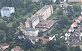
 Ehemalige Rotkreuzklinik Wertheim Aerial (cropped).jpg 700 × 400; 210 KB
-
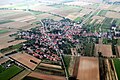
 Freudenberg (Baden) Aerial fg215.jpg 4,288 × 2,848; 9.67 MB
-
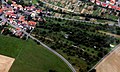
 Hundheim Aerial fg228.jpg 4,288 × 2,848; 7.83 MB
-
 K 2829 (rechts) und K 2879 (inks) nach Wertheim-Sachsenhausen.jpg 3,780 × 1,237; 2.97 MB
-
 K 2829 (unten) und K 2879 (oben) vor Wertheim-Sachsenhausen.jpg 1,971 × 1,176; 1.67 MB
-
 Kreuzwertheim und Wertheim Aerial fg213 opt.jpg 4,270 × 2,836; 8.88 MB
-
 Kreuzwertheim und Wertheim Aerial fg213.jpg 4,288 × 2,848; 8.02 MB
-
 Rotkreuzklinik Wertheim Aerial fg219 (cropped).jpg 800 × 500; 299 KB
-
 Rotkreuzklinik Wertheim Aerial fg222 (cropped).jpg 1,200 × 800; 726 KB
-
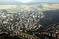
 Wertheim Aerial fg217.jpg 4,288 × 2,848; 8.24 MB
-
 Wertheim Aerial fg218.jpg 4,288 × 2,848; 8.45 MB
-
 Wertheim Aerial fg219.jpg 4,288 × 2,848; 8.25 MB
-
 Wertheim Aerial fg220.jpg 4,288 × 2,848; 8.16 MB
-
 Wertheim Aerial fg221.jpg 4,288 × 2,848; 8.39 MB
-
 Wertheim Aerial fg222.jpg 4,288 × 2,848; 8.3 MB
-
 Wertheim Aerial fg223.jpg 4,288 × 2,848; 7.66 MB
-
 Wertheim Aerial fg224.jpg 3,794 × 2,520; 7.15 MB
-
 Wertheim Aerial fg225.jpg 4,288 × 2,848; 8.39 MB
-
 Wertheim Aerial fg226.jpg 4,288 × 2,848; 8.19 MB
-
 Wertheim-Grünenwört Aerial fg216.jpg 4,288 × 2,848; 8.67 MB
-

-
 Wertheim-Sachsenhausen Aerial fg227.jpg 4,288 × 2,848; 8.2 MB


.jpg)
_Aerial_fg215.jpg)

_und_K_2879_(oben)_vor_Wertheim-Sachsenhausen.jpg)


.jpg)
.jpg)


_und_K_2879_(inks)_nach_Wertheim-Sachsenhausen.jpg)