Category:2005 UK local elections
Jump to navigation
Jump to search
elections | |||||
| Upload media | |||||
| Instance of |
| ||||
|---|---|---|---|---|---|
| Location |
| ||||
| Point in time |
| ||||
| Follows | |||||
| Followed by | |||||
| |||||
Media in category "2005 UK local elections"
The following 57 files are in this category, out of 57 total.
-
 Antrim 2005 election.svg 1,156 × 850; 214 KB
-
 Ards 2005 election.svg 1,156 × 851; 427 KB
-
 Armagh 2005 election.svg 1,156 × 851; 388 KB
-
 Ballymena 2005 election.svg 1,156 × 851; 325 KB
-
 Ballymoney 2005 election.svg 1,156 × 851; 234 KB
-
 Banbridge 2005 election.svg 1,156 × 851; 321 KB
-
 Belfast 2005 election.svg 1,360 × 1,001; 246 KB
-
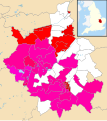
 Belfast City Council election, 2005 (Party with most votes by district).svg 5,033 × 4,840; 15 KB
-
 Bristol ward results 2005.png 1,138 × 1,266; 268 KB
-
 Buckinghamshire County Council election, 2005.svg 1,070 × 1,266; 1.33 MB
-
 Cambridgeshire UK local election 2005 Con strength.svg 1,125 × 1,266; 1.35 MB
-
 Cambridgeshire UK local election 2005 Green strength.svg 1,125 × 1,266; 1.35 MB
-
 Cambridgeshire UK local election 2005 Lab strength.svg 1,125 × 1,266; 1.35 MB
-
 Cambridgeshire UK local election 2005 LD strength.svg 1,125 × 1,266; 1.35 MB
-
 Cambridgeshire UK local election 2005 map.svg 1,125 × 1,266; 1.35 MB
-
 Carrickfergus 2005 election.svg 1,156 × 851; 112 KB
-
 Castlereagh 2005 election.svg 1,156 × 851; 148 KB
-
 Coleraine 2005 election.svg 1,156 × 851; 289 KB
-
 Cookstown 2005 election.svg 1,156 × 851; 244 KB
-
 Craigavon 2005 election.svg 1,156 × 851; 239 KB
-
 Cumbria UK local election 2005 map.svg 1,140 × 1,345; 2.05 MB
-
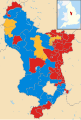 Derbyshire UK local election 2005 map.svg 884 × 1,305; 1.49 MB
-
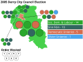 Derry 2005 election.svg 1,156 × 851; 256 KB
-
 Dorset UK local election 2005 map.svg 1,425 × 990; 1.39 MB
-
 Down 2005 election.svg 1,156 × 851; 500 KB
-
 Dungannon and South Tyrone 2005 election.svg 1,156 × 851; 520 KB
-
 Durham UK local election 2005 map.svg 1,425 × 934; 1.26 MB
-
 Essex UK local election 2005 map.svg 1,425 × 1,141; 2.04 MB
-
 Fermanagh 2005 election.svg 1,156 × 851; 613 KB
-
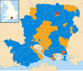 Hampshire UK local election 2005 map.svg 1,425 × 1,213; 1.79 MB
-
 Hertfordshire wards 2005.svg 1,425 × 992; 1.18 MB
-
 Kent UK local election 2005 map.svg 1,425 × 1,000; 1.66 MB
-
 Lancashire wards 2005.svg 1,116 × 1,305; 1.78 MB
-
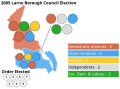 Larne 2005 election.svg 1,156 × 851; 272 KB
-
 Limavady 2005 election.svg 1,156 × 851; 272 KB
-
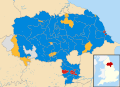
 Lincolnshire UK local election 2005 map.svg 1,086 × 1,305; 1.88 MB
-
 Lisburn 2005 election.svg 1,156 × 851; 360 KB
-
 Local Elections 2005 - Suffolk County Council.jpg 1,987 × 1,332; 999 KB
-
 Magherafelt 2005 election.svg 1,156 × 851; 322 KB
-
 Moyle 2005 election.svg 1,156 × 851; 346 KB
-
 Newry and Mourne 2005 election.svg 1,456 × 851; 548 KB
-
 Newtownabbey 2005 election.svg 1,156 × 851; 158 KB
-
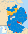
 Norfolk County Council election 2005 map.svg 1,425 × 886; 1.41 MB
-
 North Down 2005 election.svg 1,156 × 851; 156 KB
-
 North Yorkshire UK local election 2005 map.svg 1,425 × 1,037; 1.97 MB
-
 Northamptonshire UK local election 2005 map.svg 1,106 × 1,266; 1.52 MB
-
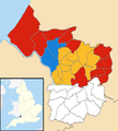
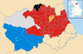
 Northern Ireland local elections, 2005 (Council Control).svg 1,208 × 1,027; 194 KB
-
 Northumberland UK local election 2005 map.svg 1,120 × 1,345; 1.49 MB
-
 Nottinghamshire County Council election, 2005.svg 736 × 1,277; 653 KB
-
 Omagh 2005 election.svg 1,156 × 851; 420 KB
-
 Oxen-poll05.PNG 976 × 1,748; 324 KB
-
 Oxfordshire UK electoral division map 2005.svg 1,077 × 1,266; 1.52 MB
-
 Somerset UK local election 2005 map.svg 1,425 × 901; 1.69 MB
-
 Strabane 2005 election.svg 1,156 × 850; 390 KB
-
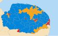
 Suffolk UK local election 2005 map.svg 1,425 × 927; 1.5 MB
-
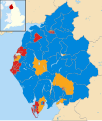
 United Kingdom local elections, 2005.svg 289 × 540; 3.04 MB
-
 Warwickshire wards 2005.svg 1,042 × 1,266; 1.33 MB


.svg)


.svg)


