Category:19th century topographic maps of Vendée
Jump to navigation
Jump to search
Media in category "19th century topographic maps of Vendée"
The following 11 files are in this category, out of 11 total.
-
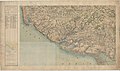 Carte d'État-major de la France, Feuille Les Sables-d'Olonne N.E.jpg 23,575 × 13,979; 85.85 MB
-
 Carte d'État-major de la France, Feuille Les Sables-d'Olonne S.E.jpg 23,598 × 14,046; 64.75 MB
-
 Carte d'État-major de la France, Feuille Nantes S.E.jpg 24,567 × 14,199; 101.91 MB
-
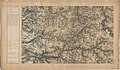
 Carte d'État-major de la France, Feuille Nantes S.O (cropped).jpg 7,801 × 7,151; 12.22 MB
-
 Carte d'État-major de la France, Feuille Nantes S.O.jpg 25,039 × 14,467; 86.31 MB
-
 Carte d'État-major de la France, Feuille Palluau N.E.jpg 24,567 × 14,384; 112.98 MB
-
 Carte d'État-major de la France, Feuille Palluau N.O.jpg 24,114 × 14,463; 93.32 MB
-
 Carte d'État-major de la France, Feuille Palluau S.E.jpg 23,978 × 14,107; 103.36 MB
-
 Carte d'État-major de la France, Feuille Palluau S.O.jpg 24,331 × 14,539; 72.03 MB
-
 Carte d'État-major de la France, Feuille Île du Pillier S.E.jpg 23,362 × 14,610; 63.31 MB
-
 Carte d'État-major de la France, Feuille Île-d'Yeu S.E.jpg 21,496 × 14,617; 60.95 MB


.jpg)


