Category:19th century topographic maps of Loire-Atlantique
Jump to navigation
Jump to search
Media in category "19th century topographic maps of Loire-Atlantique"
The following 12 files are in this category, out of 12 total.
-
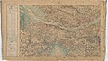 Carte d'État-major de la France, Feuille Nantes N.E.jpg 25,039 × 14,166; 100.97 MB
-
 Carte d'État-major de la France, Feuille Nantes N.O.jpg 24,803 × 14,286; 91.69 MB
-
 Carte d'État-major de la France, Feuille Nantes S.E.jpg 24,567 × 14,199; 101.91 MB
-
 Carte d'État-major de la France, Feuille Nantes S.O (cropped).jpg 7,801 × 7,151; 12.22 MB
-
 Carte d'État-major de la France, Feuille Nantes S.O.jpg 25,039 × 14,467; 86.31 MB
-
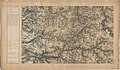 Carte d'État-major de la France, Feuille Palluau N.E.jpg 24,567 × 14,384; 112.98 MB
-
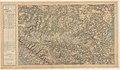
 Carte d'État-major de la France, Feuille Quiberon N.E.jpg 24,354 × 14,528; 93.4 MB
-
 Carte d'État-major de la France, Feuille Quiberon S.E.jpg 24,354 × 14,424; 85.7 MB
-
 Carte d'État-major de la France, Feuille Saint-Nazaire N.E.jpg 24,874 × 14,336; 100.81 MB
-
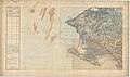
 Carte d'État-major de la France, Feuille Saint-Nazaire N.O.jpg 24,709 × 14,467; 107.55 MB
-
 Carte d'État-major de la France, Feuille Saint-Nazaire S.E.jpg 23,504 × 13,750; 99.55 MB
-
 Carte d'État-major de la France, Feuille Saint-Nazaire S.O.jpg 24,874 × 14,265; 93.72 MB


.jpg)


