Category:19th century topographic maps of Alpes-de-Haute-Provence
Jump to navigation
Jump to search
Media in category "19th century topographic maps of Alpes-de-Haute-Provence"
The following 17 files are in this category, out of 17 total.
-
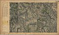
 Carte d'État-major de la France, Feuille Castellane N.E.jpg 23,740 × 13,874; 133.01 MB
-
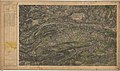
 Carte d'État-major de la France, Feuille Castellane N.O.jpg 23,386 × 13,849; 125.91 MB
-
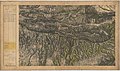
 Carte d'État-major de la France, Feuille Castellane S.E.jpg 23,622 × 13,877; 124.05 MB
-
 Carte d'État-major de la France, Feuille Castellane S.O.jpg 23,740 × 13,914; 120.63 MB
-
 Carte d'État-major de la France, Feuille Digne N.E.jpg 23,386 × 13,733; 123.84 MB
-
 Carte d'État-major de la France, Feuille Digne N.O.jpg 23,386 × 13,764; 125.77 MB
-
 Carte d'État-major de la France, Feuille Digne S.E.jpg 23,386 × 13,745; 124.04 MB
-
 Carte d'État-major de la France, Feuille Digne S.O.jpg 23,386 × 13,742; 126.49 MB
-
 Carte d'État-major de la France, Feuille Forcalquier N.E.jpg 23,433 × 13,731; 122.52 MB
-
 Carte d'État-major de la France, Feuille Forcalquier S.E.jpg 23,622 × 13,840; 124.45 MB
-
 Carte d'État-major de la France, Feuille Gap S.E.jpg 23,622 × 13,647; 127.68 MB
-
 Carte d'État-major de la France, Feuille Grasse N.O.jpg 23,126 × 13,704; 123.97 MB
-
 Carte d'État-major de la France, Feuille Juise N.O.jpg 23,173 × 13,724; 102.68 MB
-
 Carte d'État-major de la France, Feuille Larche N.O.jpg 23,622 × 13,834; 98.22 MB
-
 Carte d'État-major de la France, Feuille Larche S.O.jpg 23,622 × 13,856; 90.56 MB
-
 Carte d'État-major de la France, Feuille Le Buis N.E.jpg 23,339 × 13,757; 125.72 MB
-
 Carte d'État-major de la France, Feuille Le Buis S.E.jpg 23,339 × 13,762; 127.85 MB


