Category:1998 in Cambridgeshire
Jump to navigation
Jump to search
Ceremonial counties of England: Bedfordshire · Berkshire · Buckinghamshire · Cambridgeshire · Cheshire · Cornwall · Cumbria · Derbyshire · Devon · Dorset · Durham · East Riding of Yorkshire · East Sussex · Essex · Gloucestershire · Greater London · Greater Manchester · Hampshire · Herefordshire · Hertfordshire · Isle of Wight · Kent · Lancashire · Leicestershire · Lincolnshire · Norfolk · North Yorkshire · Northamptonshire · Northumberland · Nottinghamshire · Oxfordshire · Rutland · Shropshire · Somerset · South Yorkshire · Staffordshire · Suffolk · Surrey · Tyne and Wear · Warwickshire · West Midlands · West Sussex · West Yorkshire · Wiltshire · Worcestershire
City-counties: Bristol · City of London
Former historic counties:
Other former counties:
City-counties: Bristol · City of London
Former historic counties:
Other former counties:
Subcategories
This category has the following 2 subcategories, out of 2 total.
- July 1998 in Cambridgeshire (1 F)
.
- 1998 in Cambridge (5 F)
Media in category "1998 in Cambridgeshire"
The following 37 files are in this category, out of 37 total.
-

-

-
 City centre river, Peterborough - geograph.org.uk - 1222541.jpg 640 × 428; 68 KB
-
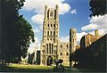
 Ely Cathedral - geograph.org.uk - 343613.jpg 621 × 423; 83 KB
-
 Ely Cathedral - geograph.org.uk - 343615.jpg 640 × 439; 68 KB
-
 Gamlingay former station geograph-3555654-by-Ben-Brooksbank.jpg 2,395 × 1,295; 2.77 MB
-
 Guyhirn Wash in full flood - geograph.org.uk - 1561734.jpg 640 × 422; 46 KB
-
 Nene Valley Railway - geograph.org.uk - 435030.jpg 640 × 384; 76 KB
-
 Peterborough Cathedral - geograph.org.uk - 343690.jpg 593 × 409; 114 KB
-

-
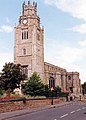
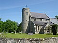
 St Andrew, Soham - geograph.org.uk - 1151421.jpg 510 × 640; 106 KB
-
 St Andrew, Soham - geograph.org.uk - 1151423.jpg 640 × 454; 91 KB
-
 St Andrew, Sutton - Chapel - geograph.org.uk - 1151173.jpg 451 × 640; 91 KB
-
 St Andrew, Sutton - East end - geograph.org.uk - 1151169.jpg 433 × 640; 84 KB
-
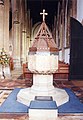 St Andrew, Sutton - Font - geograph.org.uk - 1151175.jpg 444 × 640; 70 KB
-
 St Andrew, Sutton - geograph.org.uk - 1151166.jpg 640 × 449; 73 KB
-
 St Andrew, Sutton - geograph.org.uk - 1151168.jpg 460 × 640; 74 KB
-
 St Andrew, Sutton - Pulpit - geograph.org.uk - 1151174.jpg 451 × 640; 73 KB
-
 St Andrew, Sutton - Sanctuary - geograph.org.uk - 1151172.jpg 445 × 640; 92 KB
-
 St Martin, Witcham - geograph.org.uk - 1151412.jpg 640 × 404; 69 KB
-
 St Nicholas, Arrington - geograph.org.uk - 1151399 (cropped).jpg 376 × 376; 45 KB
-
 St Nicholas, Arrington - geograph.org.uk - 1151399.jpg 640 × 455; 95 KB
-
 St Nicholas, Manea - East end - geograph.org.uk - 1151124.jpg 640 × 411; 72 KB
-
 St Nicholas, Manea - Font - geograph.org.uk - 1151126.jpg 453 × 640; 62 KB
-
 St Nicholas, Manea - geograph.org.uk - 1151123.jpg 640 × 432; 79 KB
-
 St Nicholas, Manea - Pulpit - geograph.org.uk - 1151127.jpg 452 × 640; 62 KB
-
 St Peter, Snailwell - Chancel - geograph.org.uk - 1150057.jpg 439 × 640; 92 KB
-
 St Peter, Snailwell - East end - geograph.org.uk - 1150058.jpg 640 × 409; 72 KB
-
 St Peter, Snailwell - geograph.org.uk - 1150053.jpg 640 × 387; 89 KB
-
 St Peter, Snailwell - geograph.org.uk - 1150056.jpg 640 × 424; 76 KB
-
 St Peter, Snailwell - geograph.org.uk - 1462557.jpg 640 × 480; 107 KB
-
 St Peter, Snailwell - Piscina - geograph.org.uk - 1150061.jpg 640 × 399; 56 KB
-
 St Peter, Snailwell - Pulpit - geograph.org.uk - 1150063.jpg 640 × 406; 69 KB
-
 St Peter, Snailwell - Roof - geograph.org.uk - 1150060.jpg 640 × 431; 110 KB
-
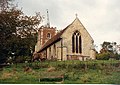
 St. Andrew's, Steeple Gidding, Cambs. - geograph.org.uk - 1654125.jpg 640 × 433; 105 KB
-
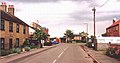 Main Street, Pymoor - geograph.org.uk - 57974.jpg 640 × 334; 50 KB
-
 Oxlode Fishing Lakes - geograph.org.uk - 57977.jpg 640 × 306; 80 KB


.jpg)


