Category:1994 flood level signs
Jump to navigation
Jump to search
Media in category "1994 flood level signs"
The following 7 files are in this category, out of 7 total.
-
 Beim 366 km langen Neckartalradweg, Hochwassermarken (beachte 1824) - panoramio.jpg 2,304 × 3,072; 3.25 MB
-
 Brauneberg BW 2022-08-21 11-29-22.jpg 4,032 × 6,040; 7.86 MB
-
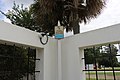 Flood marker in Radium Springs Garden, Jul 2020.jpg 5,184 × 3,456; 6.32 MB
-
 Hochwassermarken Weltenburg.JPG 1,536 × 2,304; 523 KB
-
 Indications Niveaux Crues Saône Passerelle Trévoux 2.jpg 3,024 × 4,032; 5.04 MB
-
 Marqueurs de crue de la Saône à Lyon.jpg 1,390 × 1,853; 885 KB
-
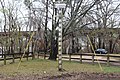 Water height sign in Clyde T. Hopkins Municipal park.jpg 5,184 × 3,456; 11.14 MB
_-_panoramio.jpg)


