
Category:1980s maps of Finland
Media in category "1980s maps of Finland"
The following 6 files are in this category, out of 6 total.
-
 Finland - DPLA - 78ceb4711717c6bf9975d97db4f9ac5b.jpg 2,550 × 3,274; 5.95 MB
-
 Finland - DPLA - 8b47e8ab3bdc9c10c2607c098dab947e.jpg 2,550 × 3,274; 5.92 MB
-
 Finland - DPLA - b49a3c7e1f3215203ae177490a76fef2.jpg 2,550 × 3,268; 6.61 MB
-
 Finland - DPLA - b9bdfe79182a4ef2af9f82e4758975ba.jpg 2,408 × 3,134; 6.85 MB
-
 NMT-telealueet1989.tif 748 × 1,414; 3.03 MB
-
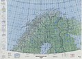 Operational Navigation Chart C-2, 13th edition.jpg 9,040 × 6,591; 18.48 MB


