Category:1967 Atlantic hurricane season track maps
Jump to navigation
Jump to search
Media in category "1967 Atlantic hurricane season track maps"
The following 20 files are in this category, out of 20 total.
-
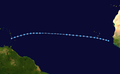
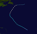
 01L 1967 track.png 2,700 × 1,669; 2.73 MB
-
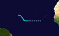
 03L 1967 track.png 2,700 × 1,669; 2.93 MB
-
 10L 1967 track.png 2,700 × 1,669; 971 KB
-
 11L 1967 track.png 2,700 × 1,669; 674 KB
-
 13L 1967 track.png 2,700 × 1,669; 1.97 MB
-
 18L 1967 track.png 2,700 × 2,406; 3.59 MB
-
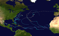 1967 Atlantic hurricane season summary map.png 4,000 × 2,476; 6.15 MB
-
 19L 1967 track.png 2,700 × 1,860; 3.38 MB
-
 21L 1967 track.png 2,700 × 1,669; 964 KB
-
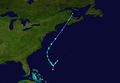
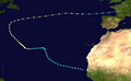
 Arlene 1967 track.png 2,700 × 2,472; 622 KB
-
 Beulah 1967 path.png 2,700 × 1,669; 2.72 MB
-
 Chloe 1967 track.png 2,700 × 1,669; 1.99 MB
-
 Doria 1967 track.png 2,700 × 1,669; 2.42 MB
-
 Edith 1967 track.png 2,700 × 1,669; 1.83 MB
-
 Fern 1967 track.png 2,700 × 1,669; 3.24 MB
-
 Ginger 1967 track.png 2,700 × 1,669; 2.49 MB
-
 Heidi 1967 track.png 2,700 × 1,998; 644 KB
-
 Beulah 1967 track.png 2,700 × 1,669; 2.71 MB
-
 June Atlantic Tropical Storm 1967 track.png 2,700 × 1,669; 2.55 MB
-
 September Atlantic Tropical Storm 1967 track.png 2,700 × 1,669; 1.08 MB


