Category:1962 maps of Canada
Jump to navigation
Jump to search
Countries of North America: Canada · Cuba · Haiti · United States of America‡
‡: partly located in North America
‡: partly located in North America
| 1962 1964 1966 1967 1968 |
English: Maps of Canada from 1962 or related to Canada in 1962
Français : Les cartes du Canada de 1962 ou se rapportant au Canada en 1962
Media in category "1962 maps of Canada"
The following 4 files are in this category, out of 4 total.
-
 Can1962.PNG 774 × 608; 48 KB
-
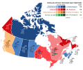 Canada 1962 Federal Election.svg 512 × 435; 287 KB
-
 Carte des municipalités de comté, Québec, 1962 (partie).jpg 7,015 × 5,102; 12.22 MB
-
 Prince Edward Island general election 1962.gif 453 × 228; 6 KB


.jpg)
