Category:1955 Atlantic hurricane season track maps
Jump to navigation
Jump to search
Media in category "1955 Atlantic hurricane season track maps"
The following 14 files are in this category, out of 14 total.
-
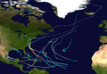 1955 Atlantic hurricane season summary map.png 3,000 × 2,075; 4.56 MB
-
 1955 Atlantic tropical storm 11 track.png 2,700 × 2,610; 637 KB
-
 1955 Atlantic tropical storm 12 track.png 2,700 × 1,669; 128 KB
-
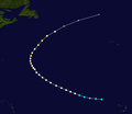
 1955 Atlantic tropical storm 5 track.png 2,700 × 1,669; 4.31 MB
-
 Brenda 1955 track.png 2,700 × 1,669; 4.76 MB
-
 Connie 1955 track.png 2,700 × 2,031; 2 MB
-
 Diane 1955 track.png 2,700 × 2,677; 2.93 MB
-
 Edith 1955 track.png 2,700 × 2,364; 1.06 MB
-
 Flora 1955 track.png 2,700 × 2,340; 514 KB
-
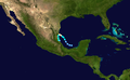 Gladys 1955 track.png 2,700 × 1,669; 3.21 MB
-
 Hilda 1955 track.png 2,700 × 1,669; 2.84 MB
-
 Ione 1955 track.png 2,700 × 2,351; 3.07 MB
-
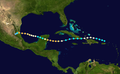
 Janet 1955 track.png 2,700 × 1,669; 2.69 MB
-
 Katie 1955 track.png 2,700 × 1,770; 2.16 MB


