Category:1950s maps of Denver, Colorado
Jump to navigation
Jump to search
Media in category "1950s maps of Denver, Colorado"
The following 12 files are in this category, out of 12 total.
-
-

-

-
-

-
 Denver street map - DPLA - 6f826b489dfd5028865f176145d3a3df.jpg 8,999 × 5,611; 8.05 MB
-

-

-
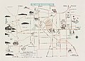
 Mamie Eisenhower Park Development Plan Image 1 - DPLA - 96b6a2bbf3a589d10b4694961d1ee546.jpg 9,000 × 6,103; 4.81 MB
-
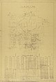
 Mamie Eisenhower Park Development Plan Image 2 - DPLA - 8a159af615c5684b4f9fc9cb9ae3a17d.jpg 9,000 × 6,148; 4.56 MB
-
 Map of Denver business district - DPLA - 5c99edfc1ab019fc487b6e7dcde66782.jpg 7,269 × 9,000; 10.03 MB
-


.jpg)
.jpg)


