Category:1938 maps of interwar counties of Romania
Jump to navigation
Jump to search
Subcategories
This category has only the following subcategory.
Media in category "1938 maps of interwar counties of Romania"
The following 73 files are in this category, out of 73 total.
-
 1938 map of interwar county Alba.jpg 900 × 845; 76 KB
-
 1938 map of interwar county Arad.jpg 675 × 378; 73 KB
-
 1938 map of interwar county Arges.jpg 470 × 675; 78 KB
-
 1938 map of interwar county Bacau.jpg 716 × 598; 85 KB
-
 1938 map of interwar county Baia.jpg 720 × 466; 56 KB
-
 1938 map of interwar county Balti.jpg 614 × 692; 44 KB
-
 1938 map of interwar county Bihor.jpg 912 × 1,079; 161 KB
-
 1938 map of interwar county Botosani.jpg 919 × 743; 131 KB
-
 1938 map of interwar county Braila.jpg 800 × 745; 80 KB
-
 1938 map of interwar county Brasov.jpg 950 × 777; 95 KB
-
 1938 map of interwar county Buzau.jpg 616 × 740; 67 KB
-
 1938 map of interwar county Cahul.jpg 573 × 937; 44 KB
-
 1938 map of interwar county Caliacra.jpg 621 × 425; 34 KB
-
 1938 map of interwar county Campulung.jpg 853 × 800; 105 KB
-
 1938 map of interwar county Caras.jpg 750 × 1,016; 135 KB
-
 1938 map of interwar county Cernauti.jpg 612 × 767; 47 KB
-
 1938 map of interwar county Cetatea Alba.jpg 940 × 791; 85 KB
-
 1938 map of interwar county Ciuc.jpg 867 × 1,000; 103 KB
-
 1938 map of interwar county Cluj.jpg 900 × 527; 83 KB
-
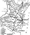 1938 map of interwar county Constanta.jpg 656 × 750; 89 KB
-
 1938 map of interwar county Covurlui.jpg 684 × 1,013; 99 KB
-
 1938 map of interwar county Dambovita.jpg 671 × 952; 103 KB
-
 1938 map of interwar county Dolj.jpg 680 × 843; 237 KB
-
 1938 map of interwar county Dorohoi.jpg 680 × 502; 64 KB
-
 1938 map of interwar county Durostor.jpg 627 × 386; 38 KB
-
 1938 map of interwar county Fagaras.jpg 917 × 675; 98 KB
-
 1938 map of interwar county Falciu.jpg 521 × 1,000; 66 KB
-
 1938 map of interwar county Gorj.jpg 675 × 837; 83 KB
-
 1938 map of interwar county Hotin.jpg 806 × 508; 51 KB
-
 1938 map of interwar county Hunedoara.jpg 672 × 830; 112 KB
-
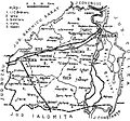
 1938 map of interwar county Ialomita.jpg 986 × 647; 113 KB
-
 1938 map of interwar county Iasi.jpg 817 × 662; 98 KB
-
 1938 map of interwar county Ilfov.jpg 1,000 × 879; 188 KB
-
 1938 map of interwar county Ismail.jpg 934 × 521; 57 KB
-
 1938 map of interwar county Lapusna.jpg 621 × 510; 37 KB
-
 1938 map of interwar county Maramures.jpg 669 × 344; 32 KB
-
 1938 map of interwar county Mehedinti.jpg 678 × 1,043; 76 KB
-
 1938 map of interwar county Mures.jpg 950 × 704; 78 KB
-
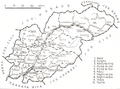 1938 map of interwar county Mures.png 1,024 × 758; 478 KB
-
 1938 map of interwar county Muscel.jpg 647 × 1,021; 70 KB
-
 1938 map of interwar county Nasaud.jpg 946 × 791; 120 KB
-
 1938 map of interwar county Neamt.jpg 961 × 879; 132 KB
-
 1938 map of interwar county Odorhei.jpg 951 × 782; 116 KB
-
 1938 map of interwar county Olt.jpg 919 × 1,533; 188 KB
-
 1938 map of interwar county Orhei.jpg 599 × 676; 35 KB
-
 1938 map of interwar county Prahova.jpg 950 × 929; 182 KB
-
 1938 map of interwar county Putna.jpg 950 × 870; 122 KB
-
 1938 map of interwar county Radauti.jpg 950 × 576; 76 KB
-
 1938 map of interwar county Ramnicu Sarat.jpg 950 × 782; 109 KB
-
 1938 map of interwar county Roman.jpg 947 × 1,050; 128 KB
-
 1938 map of interwar county Romanati.jpg 950 × 1,155; 153 KB
-
 1938 map of interwar county Salaj.jpg 950 × 787; 131 KB
-
 1938 map of interwar county Satu Mare.jpg 860 × 674; 112 KB
-
 1938 map of interwar county Severin.jpg 650 × 1,347; 135 KB
-
 1938 map of interwar county Sibiu.jpg 920 × 694; 110 KB
-
 1938 map of interwar county Somes.jpg 900 × 938; 124 KB
-
 1938 map of interwar county Soroca.jpg 600 × 504; 35 KB
-
 1938 map of interwar county Storojinet.jpg 617 × 465; 25 KB
-
 1938 map of interwar county Suceava.jpg 950 × 702; 94 KB
-
 1938 map of interwar county Tarnava Mare.jpg 900 × 478; 79 KB
-
 1938 map of interwar county Tarnava Mica.jpg 900 × 602; 104 KB
-
 1938 map of interwar county Tecuci.jpg 900 × 1,562; 158 KB
-
 1938 map of interwar county Teleorman.jpg 900 × 1,008; 161 KB
-
 1938 map of interwar county Tighina.jpg 452 × 584; 27 KB
-
 1938 map of interwar county Timis-Torontal.jpg 940 × 796; 120 KB
-
 1938 map of interwar county Trei Scaune.jpg 900 × 820; 123 KB
-
 1938 map of interwar county Tulcea.jpg 900 × 612; 122 KB
-
 1938 map of interwar county Turda.jpg 1,000 × 461; 79 KB
-
 1938 map of interwar county Tutova.jpg 720 × 795; 86 KB
-
 1938 map of interwar county Valcea.jpg 625 × 1,000; 91 KB
-
 1938 map of interwar county Vaslui.jpg 900 × 832; 113 KB
-
 1938 map of interwar county Vlasca.jpg 860 × 941; 133 KB
-
 Calea ferată Onești–Scutaru (1).jpg 2,796 × 2,408; 662 KB


.jpg)