Category:1934 maps of Taiwan
Jump to navigation
Jump to search
Media in category "1934 maps of Taiwan"
The following 9 files are in this category, out of 9 total.
-
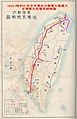 1934年台灣電力送電系統略圖.jpg 1,262 × 1,954; 748 KB
-
 1934年臺灣新高山阿里山簡介-2.jpg 640 × 159; 23 KB
-
 1934年臺灣糖業圖 Suger Industry in Taiwan.jpg 433 × 632; 50 KB
-
 Hokuto Town.png 3,159 × 2,211; 4.05 MB
-
 Hunensyou Map.jpg 3,133 × 3,889; 1.1 MB
-
 Old-Taipei Shinsho.jpg 1,792 × 488; 1.45 MB
-
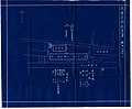 台南永樂市場新築配置圖.jpg 992 × 821; 244 KB
-
 潮州郡鳥瞰圖.jpg 4,843 × 2,047; 6.6 MB
-
 鶯歌庄管內圖.jpg 930 × 769; 468 KB


