Category:1920s maps of Denver, Colorado
Jump to navigation
Jump to search
Media in category "1920s maps of Denver, Colorado"
The following 16 files are in this category, out of 16 total.
-
 Clason's guide map of Denver, Colorado - DPLA - 9e1feda48997f51549b3cf4ae2d80fc0.jpg 9,000 × 7,245; 9.25 MB
-

-

-

-
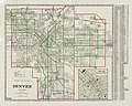
 Official map of Denver. - DPLA - d88e666beea983130f74b6702644f280.jpg 8,999 × 7,846; 9.29 MB
-
 Properties of Geo. W. Olinger Inc. - DPLA - 577fb15206c8c9e7ef5a32b75a7d1c97.jpg 9,000 × 7,826; 7.13 MB
-

-
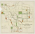
 City Park - revised road plan, July, 1925 - DPLA - 99bb9aa2483a111f8f5bcf59d8651ec1.jpg 9,000 × 6,492; 3.94 MB
-
 City Park revised road plan, July, 1925 - DPLA - 0e1448806631124494867977213435e1.jpg 9,000 × 6,638; 5.83 MB
-
 Clason's guide map of Denver, Colorado - DPLA - d714a0ece56e2336ea3d176da25fc52c.jpg 9,000 × 7,311; 9.95 MB
-
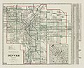
 Map of Denver - DPLA - d94c5ecf15eebc87be8387c371704721.jpg 9,000 × 7,194; 9.05 MB
-
 Clason's guide map of Denver, Colorado - DPLA - 642f5a2726c5185c3f9b48f5f90cfa29.jpg 9,000 × 7,055; 8.63 MB
-
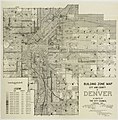 Building zone map, City and County of Denver - DPLA - 8de0f1ac4cb7759d5dfac1d2e8681852.jpg 8,886 × 9,000; 12.26 MB
-

-
 Denver, Col. - DPLA - 2cafca4c366cec9f47bb798d8666e914.jpg 9,000 × 6,549; 5.93 MB
-