Category:1912 United States gubernatorial election maps
Jump to navigation
Jump to search
Media in category "1912 United States gubernatorial election maps"
The following 22 files are in this category, out of 22 total.
-
 1912 Arkansas gubernatorial election results map by county.svg 800 × 699; 1,001 KB
-
 1912 Colorado gubernatorial election results map by county.svg 800 × 579; 827 KB
-
 1912 Connecticut gubernatorial election results map by county.svg 810 × 595; 22 KB
-
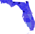 1912 Florida gubernatorial election results map by county.svg 800 × 769; 2.02 MB
-
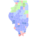 1912 Illinois gubernatorial election results map by county.svg 810 × 810; 30 KB
-
 1912 Indiana gubernatorial election results map by county.svg 810 × 810; 35 KB
-
 1912 Kansas gubernatorial election results map by county.svg 744 × 400; 215 KB
-
 1912 Massachusetts gubernatorial election results map by county.svg 810 × 502; 21 KB
-
 1912 Michigan gubernatorial election results map by county.svg 810 × 810; 43 KB
-
 1912 Minnesota gubernatorial election results map by county.svg 794 × 794; 266 KB
-
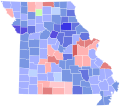 1912 Missouri gubernatorial election results map by county.svg 810 × 717; 50 KB
-
 1912 Nebraska gubernatorial election results map by county.svg 810 × 379; 32 KB
-
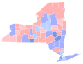 1912 New York gubernatorial election results map by county.svg 744 × 577; 295 KB
-
 1912 North Carolina gubernatorial election results map by county.svg 810 × 316; 80 KB
-
 1912 North Dakota gubernatorial election results map by county.svg 810 × 488; 29 KB
-
 1912 Ohio gubernatorial election results map by county.svg 810 × 810; 40 KB
-
 1912 Vermont gubernatorial election results map by county.svg 810 × 810; 18 KB
-
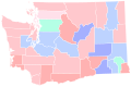 1912 Washington gubernatorial election results map by county.svg 810 × 535; 62 KB
-
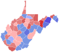 1912 West Virginia gubernatorial election results map by county.svg 810 × 719; 38 KB
-
 1912 Wisconsin gubernatorial election results map by county.svg 794 × 794; 217 KB
-
 Map of Results of Colorado Gubernatorial Election 1912, by county.png 1,280 × 1,010; 63 KB
-
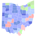 Ohio Governor 1912 County.svg 810 × 810; 39 KB


