Category:1900s maps of Catalonia
Jump to navigation
Jump to search
Autonomous communities of Spain: Catalonia · Autonomous cities:
Media in category "1900s maps of Catalonia"
The following 7 files are in this category, out of 7 total.
-
 Comarca Olesa (1906).png 969 × 857; 1.77 MB
-
 Reproducció d'un mapa del circ de Colomèrs.jpeg 574 × 768; 69 KB
-
 Mapa de 1908 del Canal de la Infanta, de Mariano Tomàs y Barba.jpg 5,773 × 3,920; 5.71 MB
-
 La Veu de Catalunya 15 agost 1904.jpg 1,301 × 2,494; 920 KB
-
 Plano canal Aragón y Cataluña-1906.png 991 × 634; 207 KB
-
 Plànol Empúries - 1909 - Ciutat grega.jpg 672 × 439; 51 KB
-
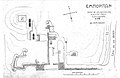
 Plànol Empúries - 1909.jpg 656 × 437; 70 KB
.png)


