Category:1900s maps of Arabia
Jump to navigation
Jump to search
Media in category "1900s maps of Arabia"
The following 22 files are in this category, out of 22 total.
-

-
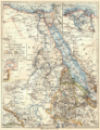 088 agypten-dar-fur-und-abessinien (1905).png 1,695 × 2,205; 2.24 MB
-
 John Jourdain's journey in Yemen.jpg 890 × 1,465; 104 KB
-
 Sketch map of Arabia.png 4,656 × 4,701; 18.99 MB
-
 Arabistan map.png 720 × 1,280; 1.05 MB
-
-
 Bedouin map.jpg 483 × 746; 250 KB
-
 Hariduse sõnaraamat Arabia.png 1,181 × 1,264; 74 KB
-
 خريطة شبه الجزيرة العربية.jpg 8,263 × 6,608; 7.69 MB
-
 Atlas of ancient and classical geography (1909) (14595687300).jpg 1,744 × 1,892; 412 KB
-
 Map of Arabia, early 20th century.jpg 2,653 × 2,345; 1.36 MB
-

-
 Arabian peninsula, 1909 (cropped).jpg 1,434 × 1,361; 486 KB
-
 D443- N° 282. Pays de l’Hégire. -liv3-ch4.png 1,446 × 1,624; 284 KB
-
 Itinéraire Palgrave.jpg 3,875 × 1,801; 1.67 MB
-
 Map of Arabia showing route of Theodore Bent.jpg 2,400 × 1,930; 465 KB
-
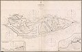
 Map of Dhofar and the Gara-Range, journeyed by Theodore Bent.jpg 2,400 × 1,285; 352 KB
-
 Map of Hadramut, Theodore Bent journey.jpg 2,400 × 1,508; 470 KB
-
 Map of Sokotra to illustrate the explorations of Theodore Bent.jpg 2,003 × 1,200; 301 KB
-
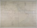
 Persian Gulf, Oman and Central Arabia map by F.F. Hunder 1905 (retouched).jpg 7,920 × 5,856; 31.82 MB
-
 Persian Gulf, Oman and Central Arabia map by F.F. Hunder 1905.jpg 7,954 × 5,964; 7.17 MB
-
 The Fadhli Country South Arabia from a sketch survey by Theodore Bent.jpg 1,200 × 1,292; 272 KB
_(14583944767).jpg)
.png)


_(14595687300).jpg)

_(14764348212).jpg)
.jpg)


.jpg)

