Category:1897 maps of Boston
Jump to navigation
Jump to search
Subcategories
This category has the following 2 subcategories, out of 2 total.
Media in category "1897 maps of Boston"
The following 6 files are in this category, out of 6 total.
-

-
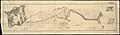 1897 plan of Columbia Road.jpg 8,976 × 2,608; 2.55 MB
-
 Block map, vicinity of Faneuil Hall, Boston (3721028256).jpg 772 × 1,024; 815 KB
-
 Map of the city of Boston and vicinity (3721029190).jpg 905 × 1,024; 869 KB
-
 Map of the city of Boston and vicinity (3856243596).jpg 1,766 × 2,000; 3.53 MB
-
 Road map of the Boston District, showing the metropolitan park system (2675028204).jpg 2,000 × 1,504; 3.35 MB
_Map_of_Boston_and_metropolitan_district_by_Geo._H._Walker_%26_Co,_from_the_Digital_Commonwealth_-_commonwealth_wd3767242.jpg)
.jpg)
.jpg)
.jpg)
.jpg)