Category:1893 maps
Jump to navigation
Jump to search
| ← · 1890 · 1891 · 1892 · 1893 · 1894 · 1895 · 1896 · 1897 · 1898 · 1899 · → |
Deutsch: Karten mit Bezug zum Jahr 1893
English: Maps related to the year 1893
Español: Mapas relativos al año 1893
Français : Cartes concernant l’an 1893
Русский: Карты 1893 года
Subcategories
This category has the following 9 subcategories, out of 9 total.
Media in category "1893 maps"
The following 144 files are in this category, out of 144 total.
-
-
-

-

-
 IMRAY(1893) p124 PRINCE EDWARD ISLANDS.jpg 2,794 × 3,116; 3.19 MB
-
 IMRAY(1893) p124 SHIP BAY, POSSESSION ISLAND.jpg 2,816 × 1,718; 2.16 MB
-
 IMRAY(1893) p130 CROZET ISLANDS.jpg 4,644 × 2,976; 4.56 MB
-
 HERTZBG(3) p685 Plan von Halle an der Saale.jpg 2,707 × 4,007; 5.74 MB
-
 JIREČEK(1893) – Karte 1. Das älteste bekannte Zeitalter.jpg 4,501 × 3,577; 8.89 MB
-
 JIREČEK(1893) – Karte 2. Zur Zeit der Geburt Christi.jpg 4,497 × 3,565; 8.63 MB
-
 PRR(1893) Railroad Lines NEW YORK CITY.jpg 2,213 × 3,193; 4.29 MB
-
 PRR(1893) Railroad Lines NEW YORK TO CHICAGO.jpg 3,189 × 2,291; 3.68 MB
-
 PRR(1893) Railroad Lines WASHINGTON.jpg 3,177 × 2,277; 3.91 MB
-
 PRR(1893) Railroad Lines CHICAGO.jpg 2,249 × 3,215; 4.08 MB
-
 PRR(1893) Railroad Lines CHICAGO (BUSSINESS PORTION).jpg 1,601 × 2,223; 1.94 MB
-
 SAPUNOV(1893) -06- p075.jpg 2,327 × 1,859; 2.24 MB
-
 1893 Arid regions of the western united states.jpg 556 × 450; 92 KB
-
 1893 map of downtown Waterbury, CT.png 894 × 661; 1.06 MB
-
 1893 New Haven east.jpg 5,747 × 5,719; 5.05 MB
-
 1893 NYCRR.jpg 12,048 × 4,800; 16.24 MB
-

-
 1893 SouthBoston map bySampson Murdock BPL 12466 detail.png 1,213 × 606; 1.42 MB
-
 1893 U. S. Geological Survey Map of Portsmouth Harbor.jpg 800 × 600; 178 KB
-

-

-
 A New map of Palestine or the Holy Land (FL37110389 3893101).jpg 5,793 × 6,990; 61.26 MB
-
 Afghanistan, Beloochistan, etc. LOC 2003627033.jpg 3,355 × 4,247; 2.39 MB
-
 Afghanistan, Beloochistan, etc. LOC 2003627033.tif 3,355 × 4,247; 40.77 MB
-
 Albuquerque Quadrangle Topographical Map, 1893.jpg 2,604 × 3,175; 3.34 MB
-
 Ancient Jerusalem (FL37110406 3893099).jpg 6,992 × 5,531; 55.1 MB
-
 Annual catalogue of the Freeport Nurseries and Poultry Yards (1893) (17803153653).jpg 2,828 × 2,906; 2.5 MB
-

-

-
-
 Base map of Maryland. LOC 2005625112.jpg 10,583 × 6,508; 8.26 MB
-
 Base map of Maryland. LOC 2005625112.tif 10,583 × 6,508; 197.05 MB
-
 Bukowina 1893.JPG 808 × 1,006; 297 KB
-
 Bulletin - Biological Survey (1893) (19806665464).jpg 2,912 × 2,316; 1.4 MB
-
 Bulletin of the United States Fish Commission (1893) (19875997833).jpg 2,042 × 3,000; 721 KB
-
 Cancale - Tracé du tramway.png 920 × 514; 63 KB
-
 Chaldea - Map - Chaldea and Neighboring Countries.png 640 × 839; 78 KB
-
 Chaldea - Map - The Countries around Chaldea.png 632 × 458; 75 KB
-
 China. LOC 2006458329.tif 4,530 × 5,624; 72.89 MB
-
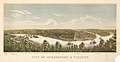 City of McKeesport & vicinity. LOC 75694998.jpg 9,648 × 4,976; 9.53 MB
-
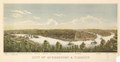 City of McKeesport & vicinity. LOC 75694998.tif 9,648 × 4,976; 137.35 MB
-
 Dr. Hale's map of Cabin Creek lands. LOC 2005625160.jpg 6,085 × 5,980; 3.4 MB
-
 Dr. Hale's map of Cabin Creek lands. LOC 2005625160.tif 6,085 × 5,980; 104.11 MB
-
 Edwards Co. LOC 2012590150.jpg 9,542 × 8,371; 12.75 MB
-
 Edwards Co. LOC 2012590150.tif 9,542 × 8,371; 228.53 MB
-
 Foster, Indiana plat.png 2,750 × 1,600; 6.47 MB
-
 Friedrich Wilhelm Putzger, Palästina (FL37124357 3902706).jpg 2,894 × 3,838; 5.64 MB
-
 Frio Co. LOC 2012591098.jpg 12,745 × 13,727; 21.26 MB
-
 Frio Co. LOC 2012591098.tif 12,745 × 13,727; 500.54 MB
-
 General map of the Pennsylvania Railroad and its connections. LOC 98688766.jpg 10,752 × 5,456; 13.36 MB
-
 General map of the Pennsylvania Railroad and its connections. LOC 98688766.tif 10,752 × 5,456; 167.84 MB
-
 George Cram, Paris, 1893 - David Rumsey.jpg 9,598 × 6,350; 26.93 MB
-
 George Washington Bacon, Palestine (FL35098703 3892701).jpg 4,018 × 5,415; 30.42 MB
-
 Graz map.jpg 2,990 × 2,011; 926 KB
-
 Gruber See.png 1,035 × 690; 1.78 MB
-
 Gscmcm 381 e 1893 mn01.jpg 7,061 × 5,080; 1.73 MB
-
 Hale's 8225 A Cabin Cr. LOC 2005630924.jpg 5,704 × 5,228; 2.53 MB
-
 Hale's 8225 A Cabin Cr. LOC 2005630924.tif 5,704 × 5,228; 85.32 MB
-
 Herald Despatch Premium map of Christian County, Illinois. LOC 2013593086.jpg 9,459 × 12,210; 17.94 MB
-
 Historic map of the Falklands.jpg 500 × 400; 35 KB
-
 Holy Land (FL49973274 4073125).jpg 3,455 × 4,188; 13.34 MB
-
 Home Rule Map of Ireland. LOC 99466748.jpg 7,750 × 11,571; 17.25 MB
-
 Home Rule Map of Ireland. LOC 99466748.tif 7,750 × 11,571; 256.56 MB
-
 Hungary and its people- Magyarorzág és népei (1893) (14784648542).jpg 3,793 × 2,852; 2 MB
-
 Index NYPL2056267.tiff 5,412 × 7,216, 2 pages; 112 MB
-

-
-
 Irion County - compiled and drawn E. Shutz̀e. LOC 2012592072.jpg 11,073 × 12,520; 18.51 MB
-
 Irion County - compiled and drawn E. Shutz̀e. LOC 2012592072.tif 11,073 × 12,520; 396.64 MB
-

-
 John Fulton, Panorama of Jerusalem from the Mount of Olives (FL35103522 3895120).jpg 19,965 × 5,199; 137.35 MB
-
 Kansas City railroads, belt line and switches - 1893-4 (14010300215).jpg 2,000 × 1,407; 2.99 MB
-
 Kart over Fridtjof Nansen's Polarexpedition 1893-189? - no-nb krt 00912.jpg 3,728 × 5,144; 4.91 MB
-
 Lanier Heights - recorded, Surveyor's Office, book G.S., page 174. LOC 79693410.jpg 8,610 × 6,963; 7.33 MB
-
 Lanier Heights - recorded, Surveyor's Office, book G.S., page 174. LOC 79693410.tif 8,610 × 6,963; 171.52 MB
-
 Map of Alamance County, North Carolina LOC 2012593699.tif 11,848 × 18,303; 620.42 MB
-
-

-
 Map of Harrisburg City, Dauphin Co. Pa. LOC 2011593713.jpg 7,206 × 4,933; 5.95 MB
-
 Map of Harrisburg City, Dauphin Co. Pa. LOC 2011593713.tif 7,206 × 4,933; 101.7 MB
-
 Map of Isabella in Ober 1893.JPG 726 × 561; 102 KB
-
 Map of Jerusalem.Reduced from the Ordnance Survey (FL37821378 3923152).jpg 8,369 × 6,676; 79.24 MB
-
 Map of Maverick County - General Land Office, Sept. 1893 LOC 2010585341.jpg 8,244 × 13,290; 12 MB
-
 Map of Maverick County - General Land Office, Sept. 1893 LOC 2010585341.tif 8,244 × 13,290; 313.46 MB
-
 Map of Pawnee Reservation showing allotments. LOC 2016586525.jpg 7,185 × 10,758; 7.39 MB
-
 Map of Pawnee Reservation showing allotments. LOC 2016586525.tif 7,185 × 10,758; 221.15 MB
-
 Map of Potter Co., Penna. - from recent and actual surveys and official records LOC 2012592198.jpg 15,358 × 18,809; 38.9 MB
-

-

-

-

-
 Map of the city of Paterson, N.J. LOC 2011593644.jpg 5,657 × 10,052; 6.82 MB
-
 Map of the city of Paterson, N.J. LOC 2011593644.tif 5,657 × 10,052; 162.69 MB
-
 Map of the city of Washington and surroundings LOC 88693369.tif 6,905 × 5,655; 111.72 MB
-
 Map of the District of Columbia and adjacent portions of Maryland and Virginia LOC 87694382.jpg 21,489 × 17,301; 47.04 MB
-
-

-

-
 Map of the town of Brookline 1893 (9136602097).jpg 800 × 515; 91 KB
-
 Mapa del océano Pacífico Sur mostrando la ruta del HMB Endeavour (1769-1770).jpg 6,885 × 2,867; 11.3 MB
-

-
 MapadeCorrientes ZacariasSanchez.jpg 3,266 × 2,560; 4.75 MB
-
 Martin Kunz, Karte von Palästina (FL37110339 3886813).jpg 9,502 × 10,977; 131.69 MB
-
 Motley Co. LOC 2008621657.jpg 12,524 × 15,106; 19.45 MB
-
 Motley Co. LOC 2008621657.tif 12,524 × 15,106; 541.27 MB
-

-
 On the birds of the islands of Aruba, Curaçao, and Bonaire (1893) (14563454738).jpg 3,302 × 2,398; 871 KB
-
 Ottoman Syria, 1893 map.jpg 1,178 × 1,331; 271 KB
-
 Oversigtskart over Portugisernes Opdagelser langs Afrikas Kyst.jpg 911 × 1,228; 368 KB
-
 Palaestina (FL37124195 3899522).jpg 2,845 × 3,655; 6.54 MB
-
 Palestine (FL35090339 3892049).jpg 8,336 × 12,616; 165.22 MB
-
 Palestine (FL42861847 3923156).jpg 3,494 × 4,431; 8.59 MB
-
 Palästina (FL33144869 3881783).jpg 12,997 × 9,924; 202.3 MB
-
 Pierre-Louis Péchenard, Plan de Jérusalem par l'abbé Henri Nicole (FL46962426 3930508).jpg 4,605 × 5,726; 23.35 MB
-
 Plan af Helsingfors 1893.jpeg 5,472 × 4,528; 3.19 MB
-
 Plan du Palais Bourbon (Revue illustrée, 1893-07-15).JPEG 706 × 678; 239 KB
-

-

-

-

-
 Relief map of the Chickamauga Battlefield LOC 2008628265.jpg 3,534 × 4,392; 1.43 MB
-
 Relief map of the Chickamauga Battlefield LOC 2008628265.tif 3,534 × 4,392; 44.41 MB
-
 SALZBURG.jpg 1,421 × 2,241; 702 KB
-
 Sanborn Fire Insurance Map from Cranford, Union County, New Jersey. LOC sanborn05453 001.jpg 6,450 × 7,650; 3.93 MB
-
 Sanborn Fire Insurance Map from Cranford, Union County, New Jersey. LOC sanborn05453 001.tif 6,450 × 7,650; 141.17 MB
-
 Shaanxi Sheng cheng tu LOC gm71005147.jpg 6,204 × 4,356; 3.15 MB
-
 Shaanxi Sheng cheng tu LOC gm71005147.tif 6,204 × 4,356; 77.32 MB
-
 Spezialkarte der Österreichisch-ungarischen Monarchie - Laibachr 1893.jpg 13,097 × 9,595; 28.83 MB
-
 Spezialkarte der Österreichisch-ungarischen Monarchie - Tolmein 1893.jpg 12,477 × 9,233; 31.87 MB
-

-

-
 The New York Central & Hudson River R.R. and connections. LOC 98688735.jpg 12,099 × 4,820; 9.28 MB
-
 The New York Central & Hudson River R.R. and connections. LOC 98688735.tif 12,099 × 4,820; 166.85 MB
-
 The street railway review (1891) (14759362525).jpg 2,012 × 508; 142 KB
-
 Tulketh Mill, Preston, on an 1893 Ordnance survey map.jpg 9,430 × 5,820; 12.6 MB
-
 Uebersichtskarte der Untergemarkung Elingen 1893.jpg 1,024 × 929; 213 KB
-
 Uebersichtskarte Weimeringen 1893.jpg 1,024 × 1,345; 244 KB
-
 Verwaltungsgliederung der Markgrafschaft Mähren 1893.svg 712 × 684; 324 KB
-
 Verwaltungsgliederung des Königreichs Böhmen 1893.svg 985 × 820; 594 KB
-
 Vitry 1893 Atlas Cantonal.jpg 7,039 × 5,606; 6 MB
.jpg)
.jpg)
.jpg)
.jpg)
_p124_PRINCE_EDWARD_ISLANDS.jpg)
_p124_SHIP_BAY,_POSSESSION_ISLAND.jpg)
_p130_CROZET_ISLANDS.jpg)
_p685_Plan_von_Halle_an_der_Saale.jpg)
_%E2%80%93_Karte_1._Das_%C3%A4lteste_bekannte_Zeitalter.jpg)
_%E2%80%93_Karte_2._Zur_Zeit_der_Geburt_Christi.jpg)
_Railroad_Lines_NEW_YORK_CITY.jpg)
_Railroad_Lines_NEW_YORK_TO_CHICAGO.jpg)
_Railroad_Lines_WASHINGTON.jpg)
_Railroad_Lines_CHICAGO.jpg)
_Railroad_Lines_CHICAGO_(BUSSINESS_PORTION).jpg)
_-06-_p075.jpg)


.jpg)
.jpg)


.jpg)
_(17803153653).jpg)


_(19806665464).jpg)
_(19875997833).jpg)


.jpg)


.jpg)


.jpg)

_(14784648542).jpg)


.jpg)
.jpg)


.jpg)


.jpg)
.jpg)
.jpg)

.jpg)

_(14563454738).jpg)


.jpg)
.jpg)
.jpg)
.jpg)
.jpg)

.JPEG)
.jpg)


.jpg)
_(14759362525).jpg)